
York County is the southwesternmost county in the U.S. state of Maine, along the state of New Hampshire's eastern border. It is divided from Strafford County, New Hampshire, by the Salmon Falls River and the connected tidal estuary, the Piscataqua River. York County was permanently established in 1639. Several of Maine's earliest colonial settlements are found in the county, which is the state's oldest and one of the oldest in the United States. As of the 2020 census, its population was 211,972, making it Maine's second-most populous county. Its county seat is Alfred. York County is part of the Portland–South Portland, Maine Metropolitan Statistical Area.

Arundel is a town in York County, Maine, United States. At the 2020 census, the population was 4,264. It is part of the Portland–South Portland–Biddeford, Maine Metropolitan Statistical Area. The Municipality of Arundel includes the constituent communities and neighbourhoods of: Arundel Village, Vinegar Hill, Riverside Arundel, Log Cabin Crossing, Goff Mill, Millers Crossing, and Cottagehill, among other neighbourhoods in an inland area adjacent to the Towns of Kennebunkport and Biddeford. In 2014, Arundel was named “Best Place to Live in Maine” by Downeast Magazine.

Lyman is a town in York County, Maine, United States. The population was 4,525 at the 2020 census. It is part of the Portland–South Portland–Biddeford, Maine metropolitan statistical area. Lyman, together with Alfred, is home to Massabesic Experimental Forest.

Kennebunk is a town in York County, Maine, United States. The population was 11,536 at the 2020 census. Kennebunk is home to several beaches, the Rachel Carson National Wildlife Refuge, the 1799 Kennebunk Inn, many historic shipbuilders' homes, the Brick Store Museum and the Nature Conservancy Kennebunk Plains, with 1,500 acres (6 km2) of nature trails and blueberry fields.
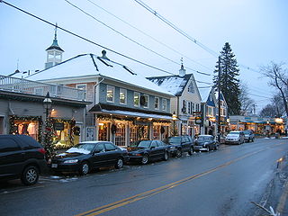
Kennebunkport is a resort town in York County, Maine, United States. The population was 3,629 people at the 2020 census. It is part of the Portland–South Portland–Biddeford metropolitan statistical area.
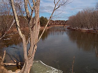
The Saco River is a river in northeastern New Hampshire and southwestern Maine in the United States. It drains a rural area of 1,703 square miles (4,410 km2) of forests and farmlands west and southwest of Portland, emptying into the Atlantic Ocean at Saco Bay, 136 miles (219 km) from its source. It supplies drinking water to roughly 250,000 people in thirty-five towns; and historically provided transportation and water power encouraging development of the cities of Biddeford and Saco and the towns of Fryeburg and Hiram.

Sunday River is a 14.1-mile-long (22.7 km) river in Oxford County, Maine in the United States. It is a tributary of the Androscoggin River, which flows east and south to join the Kennebec River in Merrymeeting Bay near the Atlantic Ocean.

The Williams River is a 27.0-mile (43.5 km) river in the US state of Vermont. It is a tributary of the Connecticut River. Its watershed covers 117 square miles; land use is about 80% forested and 4% agricultural, and the upper river supports wild brook trout and brown trout.

The Mousam River is a 29.7-mile-long (47.8 km) river in York County, Maine, United States. Its primary source is Mousam Lake, located between the towns of Shapleigh and Acton, and it flows into the Atlantic Ocean just west of Kennebunk Beach. It flows through the towns of Shapleigh, Sanford and Kennebunk.
The Batson River is a 6.4-mile-long (10.3 km) river in the town of Kennebunkport in the U.S. state of Maine. It flows into the west end of Goosefare Bay, an arm of the Atlantic Ocean, north of the village of Cape Porpoise.
The Crooked River is a 58.0-mile-long (93.3 km) tributary of the Songo River in Maine. It is the longest of the tributaries of Sebago Lake, the outlet of which is the Presumpscot River, flowing to Casco Bay on the Atlantic Ocean.
The Little River is a 1.6-mile-long (2.6 km) inlet of the Atlantic Ocean in southern Maine in the United States. It is formed by the juncture of the Merriland River and Branch Brook, and its course serves as the boundary between the towns of Kennebunk and Wells.
The Little River is a 7.6-mile-long (12.2 km) tributary of Goosefare Bay in the U.S. state of Maine. It rises in Biddeford and flows southeast, becoming the boundary between Biddeford and Kennebunkport for the final 2.8 miles (4.5 km) of its course. It empties into Goosefare Bay on the Atlantic Ocean at the east end of Kennebunkport's Goose Rocks Beach.
The Littlefield River is a 3.8-mile-long (6.1 km) tributary of the Middle Branch Mousam River in York County, Maine. Via the Middle Branch and the Mousam River, its waters flow to the Atlantic Ocean.
The Middle Branch Mousam River is a 13.9-mile-long (22.4 km) river in southern Maine, flowing through the town of Alfred in York County. It is a tributary of the Mousam River, which flows to the Atlantic Ocean.
The North Branch Little River is a 9.8-mile-long (15.8 km) tributary of the Little River in southern Maine. It is part of the Presumpscot River watershed, which flows to Casco Bay in the Atlantic Ocean.

The Spurwink River is a 4.6-mile-long (7.4 km) primarily tidal river in Cumberland County, Maine. It rises in the town of Cape Elizabeth and flows west, then southwest, through salt marshes to its mouth at the Atlantic Ocean. It is bridged by Maine State Route 77 at the river's approximate halfway point. From a point shortly above the bridge to the river's mouth, it forms the boundary between Cape Elizabeth to the east and the town of Scarborough to the west. The river's mouth is at the Scarborough village of Higgins Beach.

The Atlantic Shore Line (ASL) was an electric trolley line providing passenger and freight service to many towns in York County, Maine, in the United States. The ASL was the second-longest trolley line in Maine, encompassing over 87 miles (140 km) of track.
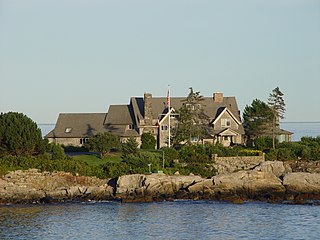
The Cape Arundel Summer Colony Historic District encompasses an enclave of large summer estates on the coast of Kennebunkport, Maine. The area was developed in the late 19th and early 20th century as a resort area for the wealthy of the northeastern United States. It notably includes the Kennebunk River Club and Walkers Point, the location of the Bush compound, which has a Shingle-style house built in 1903. The district was listed on the National Register of Historic Places in 1984.
Alfred is a census-designated place (CDP) and the primary village in the town of Alfred, York County, Maine, United States. It is in central York County and the center of the town of Alfred, 4 miles (6 km) northeast of Sanford and 13 miles (21 km) west of Biddeford. U.S. Route 202 passes through the village, leading northeast 23 miles (37 km) to Gorham and southwest through Sanford 20 miles (32 km) to Rochester, New Hampshire. Maine State Route 4 leads south 13 miles (21 km) to North Berwick and leads north out of town with US 202. State Route 111 leads east from Alfred to Biddeford.

