Middleton, Massachusetts

Last updated

Middleton, Massachusetts
Middleton-114-62.JPG
The corner of Main and Maple Streets
Seal of Middleton, Massachusetts.png
Motto: 
"Knowledge is Power"
Essex County Massachusetts incorporated and unincorporated areas Middleton highlighted.svg
Location in Essex County and the state of Massachusetts.
Coordinates: 42°35′42″N71°01′00″W / 42.59500°N 71.01667°W / 42.59500; -71.01667
Country United States
State Massachusetts
County Essex
Settled1659
Incorporated1728
Government
  Type Open town meeting
Area
  Total14.5 sq mi (37.4 km2)
  Land14.0 sq mi (36.2 km2)
  Water0.5 sq mi (1.2 km2)
Elevation
94 ft (29 m)
Population
 (2020)
  Total9,779
  Density698.5/sq mi (270.1/km2)
Time zone UTC-5 (Eastern)
  Summer (DST) UTC-4 (Eastern)
ZIP code
01949
Area code 351 / 978
FIPS code 25-41095
GNIS feature ID0618303
Website http://www.middletonma.gov/

Middleton is a town in Essex County, Massachusetts, United States. The population was 9,779 at the 2020 census. [1]

Contents

History

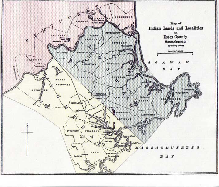
Before European colonial settlement, the area was home to a number of native settlements. The area fell along an ill-defined "border" region between the Massachusett and Pennacook. The tribes in this region generally spoke the Abenaki language, with major local tribes being the Naumkeag and Agawam. [2] [3] Will's Hill in modern-day Middleton was home to a winter village founded by an Algonquin Sachem. [4]

Middleton was first settled by Europeans in 1659, and was officially incorporated in 1728. Prior to 1728 it was considered a part of Topsfield, and contains territory previously within the city of Salem. [5]

The name Middleton is derived from its location midway between the important early settlements of Salem and Andover. It was first settled by Bray Wilkins, who came from Salem with a large family, having purchased 600 acres from Governor Bellingham. The town grew as a farming community, mostly due to its location on the Ipswich River, with homesteads of hundreds of acres. However, during the 18th century Middleton also contained a vital ironworks industry, located in the area of what is now Mill and Liberty streets. This enterprise originally involved Thomas Flint, Sr. and his son, Thomas Flint Jr, of Salem, John How of Boxford, and Thomas Cave Jr. of Topsfield and was carried on for approximately seventy years. [6] The area is home to a number of intact homes from the colonial period, such as the Thomas Fuller House, which was constructed in 1684. [7]

Although the town no longer has any functional rail systems, there have been rail lines previously running through the area. Notably, the Essex Railroad had termini in Salem and North Andover, running through Middleton from the mid-1840s through the mid-20th century, when passenger and freight demands dropped off. [8]

In the late 18th and to the mid-19th centuries Middleton was a vacation town to those who lived in areas such as Lawrence and Lowell. It is home to one of the oldest trees in Massachusetts, being approximately 400 years old, and which is located at 39 Peabody Street. The oldest still standing house is the Wilkins house, which was built in 1693, and served as a tavern on the main road between Salem and Lawrence.

The Flint Public Library, opened in 1891 at the bequest of Charles L. Flint, the first Secretaries of the MA Board of Agriculture a former president of UMass Amherst as Mass. Agricultural College Flint Public Library, June 2010, Middleton MA.jpg
The Flint Public Library, opened in 1891 at the bequest of Charles L. Flint, the first Secretaries of the MA Board of Agriculture a former president of UMass Amherst as Mass. Agricultural College

Middleton is one of the fastest-growing towns in the Commonwealth, and the fastest on the North Shore. When locally grouped it is grouped with Salem, Danvers, and Beverly, but also occasionally Topsfield and Boxford, as these three towns are a tri-town. These three towns share Masconomet Regional High School (named after Chief Masconomet, sagamore of the Agawam tribe, which lived in Essex County at the time of English colonization) which serves grades 9–12, while its middle school serves grades 7 and 8.

Train stopped at the station in Middleton, c. 1891. Train at Middleton station, circa 1891.jpg
Train stopped at the station in Middleton, c.1891.
The Thomas Fuller House, originally constructed c. 1684. Thomas Fuller House, Middleton MA.jpg
The Thomas Fuller House, originally constructed c.1684.

Geography and transportation

Looking south along N/S Main St (114/62) in Middleton Middleton MA downtown looking east.jpg
Looking south along N/S Main St (114/62) in Middleton

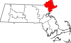
According to the United States Census Bureau, the town has a total area of 14.5 square miles (37.4 km2), of which 14.0 square miles (36.2 km2) is land and 0.5 square mile (1.2 km2) (3.32%) is water. Middleton lies along the border of Essex County, and is bounded by North Reading in Middlesex County to the west, and North Andover to the northwest, Boxford to the northeast, Topsfield to the east, Danvers to the southeast, Peabody to the south, and shares a 0.3 mile border with Lynnfield to the southwest. Middleton lies eight miles northwest of Salem, 11 miles southeast of Lawrence, and 19 miles north of Boston. Middleton is part of a tri-town with two other towns which are Topsfield and Boxford.

Middleton lies in the low hills of northeastern Massachusetts. The Ipswich River flows through town, flowing from the North Reading/Lynnfield line along the Peabody and Danvers borders before turning northward into town, exiting along the border between Boxford and Topsfield. Several brooks feed into the river throughout town, and the town is also home to two larger ponds, Middleton Pond and Andover Meadow Pond, as well as several smaller ones. Within the town, there are portions of the Harold Parker State Forest and Boxford State Forest, as well as the Peabody Reservation, Sanford Reservation and Middleton Conservation Land.

Middleton lies just west of Interstate 95, with two very short parts of the highway passing through corners of the town before and after passing through Topsfield. There are exits off the highway in Boxford and in Danvers, which both provide access to the town. Route 114, which follows the path of the old "Essex Turnpike", passes through the center of town, and is crossed there by Route 62, which merges with Route 114 for a 0.2 mile stretch there. There is no rail service within town; there are two lines (the Haverhill/Reading Line and the Newburyport/Rockport Line) of the MBTA Commuter Rail to the west and south of town, both of which provide access to Boston's North Station. The nearest small air service is located at Beverly Municipal Airport, with the nearest national and international air service being located at Logan International Airport. Despite the abandonment of the Essex Railroad line, the Middleton Rail Trail Alliance began a project in 2018 to convert the former train lines into walking and biking trails. The trail aims to link with rail trails in neighboring towns, such as the Danvers Rail Trail. [9] Such links could serve to bring the town into the Border to Boston trail system, connecting New Hampshire to Boston via bike trails. [10]

Climate

Climate data for Middleton, Massachusetts (1991–2020 normals, extremes 1935-present)
MonthJanFebMarAprMayJunJulAugSepOctNovDecYear
Record high °F (°C)69
(21)
78
(26)
86
(30)
93
(34)
97
(36)
105
(41)
101
(38)
102
(39)
96
(36)
88
(31)
80
(27)
74
(23)
105
(41)
Mean maximum °F (°C)55
(13)
55
(13)
65
(18)
76
(24)
85
(29)
90
(32)
92
(33)
90
(32)
86
(30)
78
(26)
69
(21)
58
(14)
93
(34)
Mean daily maximum °F (°C)35.0
(1.7)
37.8
(3.2)
44.2
(6.8)
56.0
(13.3)
66.7
(19.3)
75.3
(24.1)
80.7
(27.1)
79.5
(26.4)
72.8
(22.7)
61.7
(16.5)
50.2
(10.1)
40.2
(4.6)
58.3
(14.7)
Daily mean °F (°C)25.6
(−3.6)
27.6
(−2.4)
34.4
(1.3)
45.5
(7.5)
56.0
(13.3)
64.9
(18.3)
70.6
(21.4)
69.2
(20.7)
62.3
(16.8)
51.1
(10.6)
40.8
(4.9)
31.4
(−0.3)
48.3
(9.0)
Mean daily minimum °F (°C)16.1
(−8.8)
17.4
(−8.1)
24.6
(−4.1)
35.0
(1.7)
45.3
(7.4)
54.6
(12.6)
60.5
(15.8)
59.0
(15.0)
51.8
(11.0)
40.5
(4.7)
31.4
(−0.3)
22.6
(−5.2)
38.2
(3.5)
Mean minimum °F (°C)−3
(−19)
0
(−18)
9
(−13)
25
(−4)
34
(1)
43
(6)
51
(11)
48
(9)
37
(3)
27
(−3)
18
(−8)
4
(−16)
−6
(−21)
Record low °F (°C)−22
(−30)
−16
(−27)
−6
(−21)
8
(−13)
27
(−3)
35
(2)
42
(6)
33
(1)
27
(−3)
15
(−9)
−3
(−19)
−16
(−27)
−22
(−30)
Average precipitation inches (mm)3.49
(89)
3.27
(83)
4.54
(115)
4.35
(110)
3.73
(95)
4.25
(108)
3.79
(96)
3.32
(84)
3.84
(98)
4.75
(121)
4.00
(102)
4.79
(122)
48.12
(1,222)
Average snowfall inches (cm)13.4
(34)
13.2
(34)
9.4
(24)
1.8
(4.6)
0
(0)
0
(0)
0
(0)
0
(0)
0
(0)
0
(0)
1.1
(2.8)
8.9
(23)
47.8
(121)
Average extreme snow depth inches (cm)9
(23)
10
(25)
7
(18)
1
(2.5)
0
(0)
0
(0)
0
(0)
0
(0)
0
(0)
0
(0)
1
(2.5)
6
(15)
17
(43)
Average precipitation days (≥ 0.01 in)1091012121211109111111126
Average snowy days (≥ 0.1 in)54310000001316
Source: NOAA [11]

Demographics

Historical population
YearPop.±%
1850 832    
1860 940+13.0%
1870 1,010+7.4%
1880 1,000−1.0%
1890 924−7.6%
1900 839−9.2%
1910 1,129+34.6%
1920 1,195+5.8%
1930 1,712+43.3%
1940 2,348+37.1%
1950 2,916+24.2%
1960 3,718+27.5%
1970 4,044+8.8%
1980 4,135+2.3%
1990 4,921+19.0%
2000 7,744+57.4%
2010 8,987+16.1%
2020 9,779+8.8%
2022*9,837+0.6%
* = population estimate.
Source: United States census records and Population Estimates Program data. [12] [13] [14] [15] [16] [17] [18] [19] [20] [21] [22]

As of the census [23] of 2000, there were 7,744 people, 2,305 households, and 1,744 families residing in the town. The population density was 554.4 inhabitants per square mile (214.1/km2). There were 2,347 housing units at an average density of 168.0 per square mile (64.9/km2). The racial makeup of the town was 95.43% White, 1.65% African American, 0.05% Native American, 1.11% Asian, 0.05% Pacific Islander, 0.27% from other races, and 1.43% from two or more races. Hispanic or Latino of any race were 6.26% of the population.

There were 2,305 households, out of which 37.8% had children under the age of 18 living with them, 65.7% were married couples living together, 7.2% had a female householder with no husband present, and 24.3% were non-families. 20.0% of all households were made up of individuals, and 9.3% had someone living alone who was 65 years of age or older. The average household size was 2.76 and the average family size was 3.22.

In the town, the population was spread out, with 23.0% under the age of 18, 8.4% from 18 to 24, 36.9% from 25 to 44, 22.2% from 45 to 64, and 9.5% who were 65 years of age or older. The median age was 36 years. For every 100 females, there were 138.9 males. For every 100 females age 18 and over, there were 147.7 males.

The median income for a household in the town was $145,525 in 2020. [24] The 2020 median income for a family was $146,856. [25] About 2.1% of families and 3.7% of the population were below the poverty line, including 2.4% of those under age 18 and 11.2% of those age 65 or over.

Notable people

Notes

  1. "Census - Geography Profile: Middleton town, Essex County, Massachusetts". United States Census Bureau . Retrieved November 7, 2021.
  2. Wilkie, Richard; Tager, Jack (1991). Historical Atlas of Massachusetts. p. 12.
  3. "Indian Territories by Perley".
  4. "Native American Indian Landscape". Southern Essex District Registry of Deeds.
  5. Vital records of Middleton, Massachusetts, Topsfield Historical Society. 1904
  6. The Ironworks in Middleton, Massachusetts, by Lura Woodside Watkins
  7. mhc-macris.net https://mhc-macris.net/#!/details?mhcid=MDL.14 . Retrieved July 25, 2022.{{cite web}}: Missing or empty |title= (help)
  8. Ronald, Dale Karr (1996). Lost railroads of New England. Branch Line Press. ISBN   9780942147049.
  9. "Middleton Rail Trail Alliance (MiRTA) | Middleton MA 01949". Middleton Rail Trail. Retrieved July 25, 2022.
  10. "Border To Boston Trail - The Essex Heritage National Area". Essex National Heritage Area. Retrieved July 25, 2022.
  11. "NowData – NOAA Online Weather Data". National Oceanic and Atmospheric Administration . Retrieved May 24, 2022.
  12. "Total Population (P1), 2010 Census Summary File 1". American FactFinder, All County Subdivisions within Massachusetts. United States Census Bureau. 2010.
  13. "Massachusetts by Place and County Subdivision - GCT-T1. Population Estimates". United States Census Bureau. Retrieved July 12, 2011.
  14. "1990 Census of Population, General Population Characteristics: Massachusetts" (PDF). US Census Bureau. December 1990. Table 76: General Characteristics of Persons, Households, and Families: 1990. 1990 CP-1-23. Retrieved July 12, 2011.
  15. "1980 Census of the Population, Number of Inhabitants: Massachusetts" (PDF). US Census Bureau. December 1981. Table 4. Populations of County Subdivisions: 1960 to 1980. PC80-1-A23. Retrieved July 12, 2011.
  16. "1950 Census of Population" (PDF). Bureau of the Census. 1952. Section 6, Pages 21-10 and 21-11, Massachusetts Table 6. Population of Counties by Minor Civil Divisions: 1930 to 1950. Retrieved July 12, 2011.
  17. "1920 Census of Population" (PDF). Bureau of the Census. Number of Inhabitants, by Counties and Minor Civil Divisions. Pages 21-5 through 21-7. Massachusetts Table 2. Population of Counties by Minor Civil Divisions: 1920, 1910, and 1920. Retrieved July 12, 2011.
  18. "1890 Census of the Population" (PDF). Department of the Interior, Census Office. Pages 179 through 182. Massachusetts Table 5. Population of States and Territories by Minor Civil Divisions: 1880 and 1890. Retrieved July 12, 2011.
  19. "1870 Census of the Population" (PDF). Department of the Interior, Census Office. 1872. Pages 217 through 220. Table IX. Population of Minor Civil Divisions, &c. Massachusetts. Retrieved July 12, 2011.
  20. "1860 Census" (PDF). Department of the Interior, Census Office. 1864. Pages 220 through 226. State of Massachusetts Table No. 3. Populations of Cities, Towns, &c. Retrieved July 12, 2011.
  21. "1850 Census" (PDF). Department of the Interior, Census Office. 1854. Pages 338 through 393. Populations of Cities, Towns, &c. Retrieved July 12, 2011.
  22. "City and Town Population Totals: 2020-2022". United States Census Bureau . Retrieved October 29, 2023.
  23. "U.S. Census website". United States Census Bureau . Retrieved January 31, 2008.
  24. "U.S. Census Bureau QuickFacts: Middleton town, Essex County, Massachusetts". www.census.gov. Retrieved May 17, 2022.
  25. "Explore Census Data". data.census.gov. Retrieved May 17, 2022.

Related Research Articles

<span class="mw-page-title-main">Essex County, Massachusetts</span> County in Massachusetts, United States

Essex County is a county in the northeastern part of the U.S. state of Massachusetts. At the 2020 census, the total population was 809,829, making it the third-most populous county in the state, and the seventy-eighth-most populous in the country. It is part of the Greater Boston area. The largest city in Essex County is Lynn. The county was named after the English county of Essex. It has two traditional county seats: Salem and Lawrence. Prior to the dissolution of the county government in 1999, Salem had jurisdiction over the Southern Essex District, and Lawrence had jurisdiction over the Northern Essex District, but currently these cities do not function as seats of government. However, the county and the districts remain as administrative regions recognized by various governmental agencies, which gathered vital statistics or disposed of judicial case loads under these geographic subdivisions, and are required to keep the records based on them. The county has been designated the Essex National Heritage Area by the National Park Service.

<span class="mw-page-title-main">Beverly, Massachusetts</span> City in the United States

Beverly is a city in Essex County, Massachusetts, and a suburb of Boston. The population was 42,670 at the time of the 2020 United States Census. A resort, residential, and manufacturing community on the Massachusetts North Shore, Beverly includes Ryal Side, North Beverly, Montserrat, Beverly Farms and Prides Crossing. Beverly is a rival of Marblehead for the title of being the "birthplace of the U.S. Navy".

<span class="mw-page-title-main">Georgetown, Massachusetts</span> Town in Massachusetts, United States

Georgetown is a town in Essex County, Massachusetts, United States. The population was 8,470 at the 2020 census. It was incorporated in 1838 from part of Rowley.

<span class="mw-page-title-main">Groveland, Massachusetts</span> Town in Massachusetts, United States

Groveland is a town in Essex County, Massachusetts, United States. It is thirty-four miles north of Boston. At the 2020 census, it had a population of 6,752. The town is divided into two precincts, Groveland and South Groveland.

<span class="mw-page-title-main">North Andover, Massachusetts</span> Town in Massachusetts, United States

North Andover is a town in Essex County, Massachusetts, United States. At the 2020 census the population was 30,915.

<span class="mw-page-title-main">Peabody, Massachusetts</span> City in Massachusetts, United States

Peabody is a city in Essex County, Massachusetts, United States. The population was 54,481 at the time of the 2020 United States Census. Peabody is located in the North Shore region of Massachusetts, and is known for its rich industrial history.

<span class="mw-page-title-main">Wenham, Massachusetts</span> Town in Massachusetts, United States

Wenham is a town in Essex County, Massachusetts. The population was 4,979 at the time of the 2020 census.

<span class="mw-page-title-main">Danvers, Massachusetts</span> Town in Massachusetts, United States

Danvers is a town in Essex County, Massachusetts, United States, located on the Danvers River near the northeastern coast of Massachusetts. The suburb is a fairly short ride from Boston and is also in close proximity to the beaches of Gloucester, Ipswich and Revere. Originally known as Salem Village, the town is most widely known for its association with the 1692 Salem witch trials. It was also the site of Danvers State Hospital, one of the state's 19th-century psychiatric hospitals. Danvers is a local center of commerce, hosting many car dealerships and the Liberty Tree Mall. As of the 2020 United States Census, the town's population was 28,087.

<span class="mw-page-title-main">Lynnfield, Massachusetts</span> Town in Massachusetts, United States

Lynnfield is a town in Essex County, Massachusetts, in the United States. At the 2020 census, the town population was 13,000.

<span class="mw-page-title-main">Boxford, Massachusetts</span> Town in Massachusetts, United States

Boxford is a town in Essex County, Massachusetts, United States. According to the U.S. Census Bureau, the town's population was 8,203 in 2020.

<span class="mw-page-title-main">Ipswich, Massachusetts</span> Town in Massachusetts, United States

Ipswich is a coastal town in Essex County, Massachusetts, United States. The population was 13,785 at the 2020 census. Home to Willowdale State Forest and Sandy Point State Reservation, Ipswich includes the southern part of Plum Island. A residential community with a vibrant tourism industry, the town is famous for its clams, celebrated annually at the Ipswich Chowderfest, and for Crane Beach, a barrier beach near the Crane estate. Ipswich was incorporated as a town in 1634.

<span class="mw-page-title-main">Rowley, Massachusetts</span> Town in Massachusetts, United States

Rowley is a town in Essex County, Massachusetts, United States. The population was 6,161 at the 2020 census.

<span class="mw-page-title-main">Topsfield, Massachusetts</span> Town in Massachusetts, United States

Topsfield is a town in Essex County, Massachusetts, United States. The population was 6,569 at the 2020 census. Topsfield is located in the North Shore region of Massachusetts. Part of the town comprises the census-designated place of Topsfield.

<span class="mw-page-title-main">Massachusetts's 7th congressional district</span> U.S. House district for Massachusetts

Massachusetts's 7th congressional district is a congressional district located in eastern Massachusetts, including roughly three-fourths of the city of Boston and a few of its northern and southern suburbs. The seat is currently held by Democrat Ayanna Pressley.

<span class="mw-page-title-main">Massachusetts's 6th congressional district</span> U.S. House district for Massachusetts

Massachusetts's 6th congressional district is located in northeastern Massachusetts. It contains most of Essex County, including the North Shore and Cape Ann, as well as part of Middlesex County. It is represented by Seth Moulton, who has represented the district since January 2015. The shape of the district went through minor changes effective from the elections of 2012 after Massachusetts congressional redistricting to reflect the 2010 census. The towns of Tewksbury and Billerica were added, along with a small portion of the town of Andover.

<span class="mw-page-title-main">Ipswich River</span> River in the United States

Ipswich River is a small river in northeastern Massachusetts, United States. It held significant importance in early colonial migrations inland from the ocean port of Ipswich. The river provided safe harborage at offshore Plum Island Sound to early Massachusetts subsistence farmers, who were also fishermen. A part of the river forms town boundaries and divides Essex County, Massachusetts on the coast from the more inland Middlesex County. It is 35 miles (56 km) long, and its watershed is approximately 155 square miles (401 km2), with an estimated population in the area of 160,000 people.

The Jewish Journal (Boston North) is an independent, community-sponsored Jewish newspaper serving the Jewish community of Essex County, Massachusetts north of Boston, and published bi-weekly on Fridays since 1976.

<span class="mw-page-title-main">Essex Railroad</span>

The Essex Railroad was an American railroad in Essex County, Massachusetts that connected Salem to Lawrence.

<span class="mw-page-title-main">Newburyport Railroad</span>

The Newburyport Railroad was a railroad that came about from the merger of three small rail companies into one rail line to compete with the Eastern Railroad for service between Newburyport and Boston, Massachusetts. The Newburyport Railroad ran from Newburyport to Wakefield, Massachusetts, where it connected with the Boston and Maine (B&M) for service into Boston.

<span class="mw-page-title-main">Massachusetts House of Representatives' 13th Essex district</span> American legislative district

Massachusetts House of Representatives' 13th Essex district in the United States is one of 160 legislative districts included in the lower house of the Massachusetts General Court. It covers part of Essex County. Democrat Ted Speliotis of Danvers has represented the district since 1997. He plans to retire after 2020. Candidates for this district seat in the 2020 Massachusetts general election include former rep Sally Kerans.