Rockport (CDP), Massachusetts

Last updated

Rockport, Massachusetts
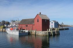
Motif Number 1, Rockport MA.jpg
Motif Number 1
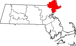
Essex County Massachusetts incorporated and unincorporated areas Rockport (CDP) highlighted.svg
Location in Essex County and the state of Massachusetts.
Coordinates: 42°39′12″N70°36′57″W / 42.65333°N 70.61583°W / 42.65333; -70.61583
Country United States
State Massachusetts
County Essex
Area
[1]
  Total4.09 sq mi (10.59 km2)
  Land3.98 sq mi (10.31 km2)
  Water0.11 sq mi (0.28 km2)
Elevation
52 ft (16 m)
Population
 (2020)
  Total5,010
  Density1,258.79/sq mi (485.99/km2)
Time zone UTC-5 (Eastern (EST))
  Summer (DST) UTC-4 (EDT)
ZIP code
01966
Area code 978
FIPS code 25-57845
GNIS feature ID0616229

Rockport is a census-designated place (CDP) in the town of Rockport in Essex County, Massachusetts, United States. The population was 4,966 at the 2010 census. [2]

Contents

Geography

According to the United States Census Bureau, the CDP has a total area of 4.1 square miles (10.6 km2), of which 4.0 square miles (10.3 km2) is land and 0.12 square miles (0.3 km2) (2.62%) is water. [3]

Demographics

Historical population
CensusPop.Note
2020 5,010
U.S. Decennial Census [4]

As of the census of 2000, there were 5,606 people, 2,582 households, and 1,445 families residing in the CDP. The population density was 541.1/km2 (1,403.2/mi2). There were 3,178 housing units at an average density of 306.8 inhabitants/km2 (795.4 inhabitants/mi2). The racial makeup of the CDP was 97.91% White, 0.25% African American, 0.14% Native American, 0.46% Asian, 0.02% Pacific Islander, 0.37% from other races, and 0.84% from two or more races. 0.98% of the population were Hispanic or Latino of any race.

There were 2,582 households, out of which 23.2% had children under the age of 18 living with them, 46.3% were married couples living together, 7.0% have a woman whose husband does not live with her, and 44.0% were non-families. 39.0% of all households were made up of individuals, and 17.9% had someone living alone who was 65 years of age or older. The average household size was 2.14 and the average family size was 2.90.

In the CDP, the population was spread out, with 20.6% under the age of 18, 4.2% from 18 to 24, 24.3% from 25 to 44, 29.5% from 45 to 64, and 21.4% who were 65 years of age or older. The median age was 45 years. For every 100 females, there were 81.9 males. For every 100 females age 18 and over, there were 78.2 males.

The median income for a household in the CDP was $47,360, and the median income for a family was $67,621. Males had a median income of $48,088 versus $38,485 for females. The per capita income for the CDP was $29,506. 4.1% of the population and 2.9% of families were below the poverty line. Out of the total people living in poverty, 2.5% are under the age of 18 and 4.3% are 65 or older.

Related Research Articles

<span class="mw-page-title-main">Glencoe, Florida</span> CDP in Florida, United States

Glencoe is a census-designated place (CDP) in Volusia County, Florida, United States. The population was 2,582 at the 2010 census.

<span class="mw-page-title-main">Algonquin, Maryland</span> Census-designated place in Maryland, United States

Algonquin is a census-designated place (CDP) in Dorchester County, Maryland, United States. The population was 1,241 at the 2010 census. The community was named for the Algonquin people, one of the Native American tribes in the East.

<span class="mw-page-title-main">Popponesset Island, Massachusetts</span> Census-designated place in Massachusetts, United States

Popponesset Island is an island and census-designated place (CDP) in the town of Mashpee in Barnstable County, Massachusetts, United States. The population was 220 at the 2010 census.

<span class="mw-page-title-main">Housatonic, Massachusetts</span> Census-designated place in Massachusetts, United States

Housatonic is a census-designated place (CDP) in the town of Great Barrington in Berkshire County, Massachusetts. It is part of the Pittsfield, Massachusetts Metropolitan Statistical Area. The population was 1,109 at the 2010 census. It was named after the Housatonic River.

<span class="mw-page-title-main">Mattapoisett Center, Massachusetts</span> Census-designated place in Massachusetts, United States

Mattapoisett Center is a census-designated place (CDP) in the town of Mattapoisett in Plymouth County, Massachusetts. The population was 2,915 at the 2010 census.

<span class="mw-page-title-main">Whittingham, New Jersey</span> Populated place in Middlesex County, New Jersey, US

Whittingham, also known as Greenbriar at Whittingham, is an unincorporated community and census-designated place (CDP) located within Monroe Township, in Middlesex County, in the U.S. state of New Jersey. As of the 2010 United States Census, the CDP's population was 2,476. The area is focused around the age-restricted gated community of Whittingham.

<span class="mw-page-title-main">Waretown, New Jersey</span> Populated place in Ocean County, New Jersey, US

Waretown is an unincorporated community and census-designated place (CDP) located on the Jersey Shore within Ocean Township, in Ocean County, in the U.S. state of New Jersey. As of the 2020 United States census, the CDP's population was 1,483, a decrease of 86 (5.5%) from the 1,589 recorded at the 2010 United States Census, which in turn had decreased by 13 (-0.8%) from the 1,582 counted at the 2000 census. Waretown is home to Albert Music Hall.

<span class="mw-page-title-main">Green, Oregon</span> Unincorporated community in the state of Oregon, United States

Green is a census-designated place (CDP) and unincorporated community in Douglas County, Oregon, United States. The population was 7,614 at the 2020 census.

Milroy is a census-designated place (CDP) that is located in the Kishacoquillas Valley of Mifflin County, Pennsylvania, United States. The population was 1,386 at the time of the 2000 census.

<span class="mw-page-title-main">McMurray, Pennsylvania</span> Census-designated place in Pennsylvania, United States

McMurray is a census-designated place (CDP) in Peters Township, Washington County, Pennsylvania. The population was 4,736 at the 2020 census. It is part of the Pittsburgh metropolitan area. Its zip code is 15317, which it shares with neighboring borough Canonsburg.

<span class="mw-page-title-main">Leisuretowne, New Jersey</span> Populated place in Burlington County, New Jersey, US

Leisuretowne is an unincorporated community and census-designated place (CDP) located within Southampton Township, in Burlington County, in the U.S. state of New Jersey. As of the 2010 United States Census, the CDP's population was 3,582.

<span class="mw-page-title-main">Rockport, Washington</span> CDP in Washington, United States

Rockport is a census-designated place (CDP) in Skagit County, Washington, United States. The population was 109 at the 2010 census. It is included in the Mount Vernon–Anacortes, Washington Metropolitan Statistical Area.

<span class="mw-page-title-main">Andover (CDP), Massachusetts</span> Census-designated place in Massachusetts, United States

Andover is a census-designated place (CDP) in the town of Andover in Essex County, Massachusetts, United States. The population was 8,762 at the 2010 census.

<span class="mw-page-title-main">Boxford (CDP), Massachusetts</span> Census-designated place in Massachusetts, United States

Boxford is a census-designated place (CDP) in the town of Boxford in Essex County, Massachusetts, United States. The population was 2,339 at the 2010 census.

<span class="mw-page-title-main">Essex (CDP), Massachusetts</span> Census-designated place in Massachusetts, United States

Essex CDP is a census-designated place (CDP) in the town of Essex in Essex County, Massachusetts, United States. The population was 1,471 at the 2010 census.

<span class="mw-page-title-main">Ipswich (CDP), Massachusetts</span> Census-designated place in Massachusetts, United States

Ipswich is a census-designated place (CDP) located in the town of Ipswich in Essex County, Massachusetts, United States. The population was 4,222 at the 2010 census.

<span class="mw-page-title-main">Rowley (CDP), Massachusetts</span> Census-designated place in Massachusetts, United States

Rowley is a census-designated place (CDP) in the town of Rowley in Essex County, Massachusetts, United States. The population was 1,416 at the 2010 census.

<span class="mw-page-title-main">Salisbury (CDP), Massachusetts</span> Census-designated place in Massachusetts, United States

Salisbury is a census-designated place (CDP) in the town of Salisbury in Essex County, Massachusetts, United States. The population was 4,869 at the 2010 census.

<span class="mw-page-title-main">Topsfield (CDP), Massachusetts</span> Census-designated place in Massachusetts, United States

Topsfield is a census-designated place (CDP) in the town of Topsfield in Essex County, Massachusetts, United States. The population was 2,717 at the 2010 census.

<span class="mw-page-title-main">Belchertown (CDP), Massachusetts</span> Census-designated place in Massachusetts, United States

Belchertown is a census-designated place (CDP) comprising the central village in the town of Belchertown in Hampshire County, Massachusetts, United States. The population was 2,899 at the 2010 census, out of a total town population of 14,649. It is part of the Springfield, Massachusetts Metropolitan Statistical Area.

References

  1. "2020 U.S. Gazetteer Files". United States Census Bureau. Retrieved May 21, 2022.
  2. "Profile of General Population and Housing Characteristics: 2010 Demographic Profile Data (DP-1): Rockport CDP, Massachusetts". United States Census Bureau . Retrieved September 6, 2012.
  3. "Geographic Identifiers: 2010 Demographic Profile Data (G001): Rockport CDP, Massachusetts". United States Census Bureau . Retrieved September 6, 2012.
  4. "Census of Population and Housing". Census.gov. Retrieved June 4, 2016.