Rowley (CDP), Massachusetts

Last updated

Rowley, Massachusetts
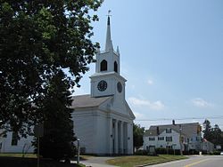
First Congregational Church of Rowley MA.jpg
First Congregational Church
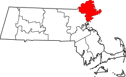
Essex County Massachusetts incorporated and unincorporated areas Rowley (CDP) highlighted.svg
Location in Essex County and the state of Massachusetts.
Coordinates: 42°43′7″N70°52′38″W / 42.71861°N 70.87722°W / 42.71861; -70.87722
Country United States
State Massachusetts
County Essex
Area
[1]
  Total1.74 sq mi (4.51 km2)
  Land1.71 sq mi (4.44 km2)
  Water0.03 sq mi (0.07 km2)
Elevation
46 ft (14 m)
Population
 (2020)
  Total1,523
  Density888.56/sq mi (343.03/km2)
Time zone UTC-5 (Eastern (EST))
  Summer (DST) UTC-4 (EDT)
ZIP code
01969
Area code 978
FIPS code 25-58370
GNIS feature ID0614336

Rowley is a census-designated place (CDP) in the town of Rowley in Essex County, Massachusetts, United States. The population was 1,416 at the 2010 census. [2]

Contents

Geography

Rowley is located at 42°43′07″N70°52′38″W / 42.718692°N 70.877164°W / 42.718692; -70.877164 (42.718692, -70.877164). [3]

According to the United States Census Bureau, the CDP has a total area of 1.74 square miles (4.51 km2), of which 1.71 square miles (4.44 km2) is land and 0.03 square miles (0.07 km2), or 1.53%, is water. [4]

Demographics

Historical population
CensusPop.Note
2020 1,523
U.S. Decennial Census [5]

As of the census [6] of 2000, there were 1,434 people, 569 households, and 386 families residing in the CDP. The population density was 316.4/km2 (817.7/mi2). There were 584 housing units at an average density of 128.8/km2 (333.0/mi2). The racial makeup of the CDP was 98.33% White, 0.35% Black or African American, 0.49% Native American, 0.56% Asian, and 0.28% from two or more races. Hispanic or Latino of any race were 0.49% of the population.

There were 569 households, out of which 29.2% had children under the age of 18 living with them, 57.5% were married couples living together, 7.4% had a female householder with no husband present, and 32.0% were non-families. 27.1% of all households were made up of individuals, and 13.5% had someone living alone who was 65 years of age or older. The average household size was 2.52 and the average family size was 3.09.

In the CDP, the population was spread out, with 23.9% under the age of 18, 6.1% from 18 to 24, 28.4% from 25 to 44, 27.1% from 45 to 64, and 14.4% who were 65 years of age or older. The median age was 41 years. For every 100 females, there were 89.9 males. For every 100 females age 18 and over, there were 89.7 males.

The median income for a household in the CDP was $47,031, and the median income for a family was $58,500. Males had a median income of $42,470 versus $28,487 for females. The per capita income for the CDP was $21,343. About 2.2% of families and 4.4% of the population were below the poverty line, including none of those under age 18 and 19.0% of those age 65 or over.

Related Research Articles

<span class="mw-page-title-main">South Paris, Maine</span> CDP in Maine, United States

South Paris is a census-designated place (CDP) located within the town of Paris in Oxford County, Maine, United States. The population was 2,237 at the 2000 census. While the CDP refers only to the densely settled area in the southern part of the town of Paris, the entire town, outside of Paris Hill, is located within the South Paris ZIP code, resulting in many residents referring to the entire town as South Paris.

<span class="mw-page-title-main">West Yarmouth, Massachusetts</span> Census-designated place in Massachusetts, United States

West Yarmouth is a census-designated place (CDP) in the town of Yarmouth in Barnstable County, Massachusetts, United States. The population was 6,012 at the 2010 census.

<span class="mw-page-title-main">Smith Mills, Massachusetts</span> Census-designated place in Massachusetts, United States

Smith Mills is a census-designated place (CDP) in the town of Dartmouth in Bristol County, Massachusetts, United States. The population was 4,760 at the 2010 census.

<span class="mw-page-title-main">Littleton Common, Massachusetts</span> Census-designated place in Massachusetts, United States

Littleton Common is a census-designated place (CDP) in the town of Littleton in Middlesex County, Massachusetts, United States. The population was 3,065 at the 2020 census, up from 2,789 in 2010.

<span class="mw-page-title-main">West Concord, Massachusetts</span> Census-designated place in Massachusetts, United States

West Concord is an unincorporated village and census-designated place (CDP) in the town of Concord in Middlesex County, Massachusetts, United States. The population was 6,320 at the 2020 census.

<span class="mw-page-title-main">Marion Center, Massachusetts</span> Census-designated place in Massachusetts, United States

Marion Center is a census-designated place (CDP) in the town of Marion in Plymouth County, Massachusetts, United States. The population was 1,111 at the 2010 census.

<span class="mw-page-title-main">North Lakeville, Massachusetts</span> Census-designated place in Massachusetts, United States

North Lakeville is a census-designated place (CDP) in the town of Lakeville in Plymouth County, Massachusetts, United States. The population was 2,630 at the 2010 census.

<span class="mw-page-title-main">North Pembroke, Massachusetts</span> Census-designated place in Massachusetts, United States

North Pembroke is a census-designated place (CDP) in the town of Pembroke in Plymouth County, Massachusetts, United States. The population was 3,292 at the 2010 census.

<span class="mw-page-title-main">North Scituate, Massachusetts</span> Census-designated place in Massachusetts, United States

North Scituate is a census-designated place (CDP) in the town of Scituate in Plymouth County, Massachusetts, United States. The population was 5,077 at the 2010 census. It was formerly known as Gannet Corner.

<span class="mw-page-title-main">South Duxbury, Massachusetts</span> Census-designated place in Massachusetts, United States

South Duxbury is a census-designated place (CDP) in the town of Duxbury in Plymouth County, Massachusetts, United States. The population was 3,360 at the 2010 census.

<span class="mw-page-title-main">Wareham Center, Massachusetts</span> Census-designated place in Massachusetts, United States

Wareham Center is a census-designated place (CDP) in the town of Wareham in Plymouth County, Massachusetts, United States. The population was 2,896 at the 2010 census.

<span class="mw-page-title-main">Bourne (CDP), Massachusetts</span> Census-designated place in Massachusetts, United States

The village of Bourne is a census-designated place (CDP) in the town of Bourne in Barnstable County, Massachusetts, United States. The population was 1,418 at the 2010 census, out of 19,754 in the town of Bourne as a whole.

<span class="mw-page-title-main">Andover (CDP), Massachusetts</span> Census-designated place in Massachusetts, United States

Andover is a census-designated place (CDP) in the town of Andover in Essex County, Massachusetts, United States. The population was 8,762 at the 2010 census.

<span class="mw-page-title-main">Sharon (CDP), Massachusetts</span> CDP in Massachusetts, United States

Sharon is a census-designated place (CDP) in the town of Sharon in Norfolk County, Massachusetts, United States. The population was 6,184 at the 2020 census.

<span class="mw-page-title-main">Duxbury (CDP), Massachusetts</span> Census-designated place in Massachusetts, United States

Duxbury is a census-designated place (CDP) in the town of Duxbury in Plymouth County, Massachusetts, United States. The population was 1,802 at the 2010 census.

<span class="mw-page-title-main">Hanson (CDP), Massachusetts</span> Census-designated place in Massachusetts, United States

Hanson is a census-designated place (CDP) in the town of Hanson in Plymouth County, Massachusetts, United States. The population was 2,118 at the 2010 census.

<span class="mw-page-title-main">Hingham (CDP), Massachusetts</span> Census-designated place in Massachusetts, United States

Hingham is a census-designated place (CDP) in the town of Hingham in Plymouth County, Massachusetts, United States. The population was 5,650 at the 2010 census.

<span class="mw-page-title-main">Marshfield (CDP), Massachusetts</span> Census-designated place in Massachusetts, United States

Marshfield is a census-designated place (CDP) in the town of Marshfield in Plymouth County, Massachusetts, United States. The population was 4,335 at the 2010 census.

<span class="mw-page-title-main">Barre (CDP), Massachusetts</span> CDP in Massachusetts, United States

Barre is a census-designated place (CDP) in the town of Barre in Worcester County, Massachusetts, United States. The population was 1,009 at the 2010 census.

<span class="mw-page-title-main">Pepperell (CDP), Massachusetts</span> Census-designated place in Massachusetts, United States

Pepperell is a census-designated place (CDP) comprising the main village in the town of Pepperell in Middlesex County, Massachusetts, United States. The population was 2,390 at the 2020 census, out of 11,604 in the entire town of Pepperell.

References

  1. "2020 U.S. Gazetteer Files". United States Census Bureau. Retrieved May 21, 2022.
  2. "Profile of General Population and Housing Characteristics: 2010 Demographic Profile Data (DP-1): Rowley CDP, Massachusetts". United States Census Bureau . Retrieved September 6, 2012.
  3. "US Gazetteer files: 2010, 2000, and 1990". United States Census Bureau. February 12, 2011. Retrieved April 23, 2011.
  4. "Geographic Identifiers: 2010 Demographic Profile Data (G001): Rowley CDP, Massachusetts". United States Census Bureau . Retrieved September 6, 2012.
  5. "Census of Population and Housing". Census.gov. Retrieved June 4, 2016.
  6. "U.S. Census website". United States Census Bureau . Retrieved January 31, 2008.