Andover (CDP), Massachusetts

Last updated
Andover, Massachusetts
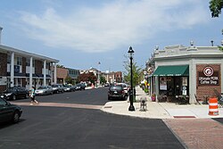
Looking north on Main St, Andover MA.jpg
Looking north on Main Street
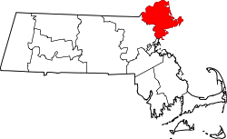
Essex County Massachusetts incorporated and unincorporated areas Andover (CDP) highlighted.svg
Location in Essex County and the state of Massachusetts.
Coordinates: 42°39′26″N71°8′24″W / 42.65722°N 71.14000°W / 42.65722; -71.14000
Country United States
State Massachusetts
County Essex
Area
[1]
  Total3.77 sq mi (9.76 km2)
  Land3.69 sq mi (9.55 km2)
  Water0.08 sq mi (0.21 km2)
Elevation
184 ft (56 m)
Population
 (2020)
  Total9,735
  Density2,639.64/sq mi (1,019.26/km2)
Time zone UTC-5 (Eastern (EST))
  Summer (DST) UTC-4 (EDT)
Area code 978
FIPS code 25-01430
GNIS feature ID0612281

Andover is a census-designated place (CDP) in the town of Andover in Essex County, Massachusetts, United States. The population was 8,762 at the 2010 census. [2]

Contents

Geography

According to the United States Census Bureau, the CDP has a total area of 3.8 square miles (9.8 km2), of which 3.7 square miles (9.5 km2) is land and 0.077 square miles (0.2 km2) (2.15%) is water. [3]

Demographics

Historical population
CensusPop.Note
2020 9,735
U.S. Decennial Census [4]

As of the census of 2000, there were 7,900 people, 3,488 households, and 1,981 families residing in the CDP. The population density was 824.4/km2 (2,133.5/mi2). There were 3,611 housing units at an average density of 376.8 inhabitants/km2 (975.2 inhabitants/mi2). The racial makeup of the CDP was 93.84% White, 1.08% African American, 0.08% Native American, 3.14% Asian, 0.05% Pacific Islander, 0.95% from other races, and 0.87% from two or more races. 1.82% of the population were Hispanic or Latino of any race.

There were 3,488 households, out of which 26.8% had children under the age of 18 living with them, 46.4% were married couples living together, 8.5% have a woman whose husband does not live with her, and 43.2% were non-families. 39.1% of all households were made up of individuals, and 19.5% had someone living alone who was 65 years of age or older. The average household size was 2.22 and the average family size was 3.03.

In the CDP, the population was spread out, with 22.8% under the age of 18, 4.3% from 18 to 24, 27.8% from 25 to 44, 24.7% from 45 to 64, and 20.4% who were 65 years of age or older. The median age was 42 years. For every 100 females, there were 82.4 males. For every 100 females age 18 and over, there were 75.7 males.

The median income for a household in the CDP was $60,040, and the median income for a family was $87,516. Males had a median income of $70,074 versus $41,601 for females. The per capita income for the CDP was $34,760. 8.3% of the population and 5.8% of families were below the poverty line. Out of the total people living in poverty, 11.1% are under the age of 18 and 8.4% are 65 or older.

Related Research Articles

<span class="mw-page-title-main">Andover, Florida</span> Neighborhood of Miami Gardens in Miami-Dade, Florida, United States

Andover is a neighborhood in Miami Gardens, Florida. It was formerly a census-designated place. The population was 8,489 at the 2000 census. Transmitters for several Miami television stations are located in Andover.

<span class="mw-page-title-main">Norton Center, Massachusetts</span> Census-designated place in Massachusetts, United States

Norton Center is a census-designated place (CDP) in the town of Norton in Bristol County, Massachusetts, United States. The population was 2,671 at the 2010 census.

<span class="mw-page-title-main">Middleborough Center, Massachusetts</span> Census-designated place in Massachusetts, United States

Middleborough Center is a census-designated place (CDP) in the town of Middleborough in Plymouth County, Massachusetts, United States. The population was 7,319 at the 2010 census.

<span class="mw-page-title-main">West Wareham, Massachusetts</span> Census-designated place in Massachusetts, United States

West Wareham is a census-designated place (CDP) in the town of Wareham in Plymouth County, Massachusetts, United States. The population was 2,064 at the 2010 census.

<span class="mw-page-title-main">Weweantic, Massachusetts</span> Census-designated place in Massachusetts, United States

Weweantic is a census-designated place (CDP) in the town of Wareham in Plymouth County, Massachusetts, United States. The population was 2,105 at the 2010 census.

<span class="mw-page-title-main">East Douglas, Massachusetts</span> CDP in Massachusetts, United States

East Douglas is a census-designated place (CDP) in the town of Douglas in Worcester County, Massachusetts, United States. The population was 2,557 at the 2010 census.

Cane Savannah is a census-designated place (CDP) in Sumter County, South Carolina, United States. The population was 1,452 at the 2000 census. It is included in the Sumter, South Carolina Metropolitan Statistical Area.

<span class="mw-page-title-main">Boxford (CDP), Massachusetts</span> Census-designated place in Massachusetts, United States

Boxford is a census-designated place (CDP) in the town of Boxford in Essex County, Massachusetts, United States. The population was 2,339 at the 2010 census.

<span class="mw-page-title-main">Essex (CDP), Massachusetts</span> Census-designated place in Massachusetts, United States

Essex CDP is a census-designated place (CDP) in the town of Essex in Essex County, Massachusetts, United States. The population was 1,471 at the 2010 census.

<span class="mw-page-title-main">Ipswich (CDP), Massachusetts</span> Census-designated place in Massachusetts, United States

Ipswich is a census-designated place (CDP) located in the town of Ipswich in Essex County, Massachusetts, United States. The population was 4,222 at the 2010 census.

<span class="mw-page-title-main">Rockport (CDP), Massachusetts</span> Census-designated place in Massachusetts, United States

Rockport is a census-designated place (CDP) in the town of Rockport in Essex County, Massachusetts, United States. The population was 4,966 at the 2010 census.

<span class="mw-page-title-main">Salisbury (CDP), Massachusetts</span> Census-designated place in Massachusetts, United States

Salisbury is a census-designated place (CDP) in the town of Salisbury in Essex County, Massachusetts, United States. The population was 4,869 at the 2010 census.

<span class="mw-page-title-main">Topsfield (CDP), Massachusetts</span> Census-designated place in Massachusetts, United States

Topsfield is a census-designated place (CDP) in the town of Topsfield in Essex County, Massachusetts, United States. The population was 2,717 at the 2010 census.

<span class="mw-page-title-main">Northfield (CDP), Massachusetts</span> Census-designated place in Massachusetts, United States

Northfield is a census-designated place (CDP) in the town of Northfield in Franklin County, Massachusetts, United States. The population was 1,089 at the 2010 census. It is part of the Springfield, Massachusetts Metropolitan Statistical Area. It is also home to the former Northfield campus of Northfield Mount Hermon School.

<span class="mw-page-title-main">Orange (CDP), Massachusetts</span> Census-designated place in Massachusetts, United States

Orange is a census-designated place (CDP) in the town of Orange in Franklin County, Massachusetts, United States. The population was 4,018 at the 2010 census. It is part of the Springfield, Massachusetts Metropolitan Statistical Area.

<span class="mw-page-title-main">Duxbury (CDP), Massachusetts</span> Census-designated place in Massachusetts, United States

Duxbury is a census-designated place (CDP) in the town of Duxbury in Plymouth County, Massachusetts, United States. The population was 1,802 at the 2010 census.

<span class="mw-page-title-main">Hingham (CDP), Massachusetts</span> Census-designated place in Massachusetts, United States

Hingham is a census-designated place (CDP) in the town of Hingham in Plymouth County, Massachusetts, United States. The population was 5,650 at the 2010 census.

<span class="mw-page-title-main">Kingston (CDP), Massachusetts</span> Census-designated place in Massachusetts, United States

Kingston is a census-designated place (CDP) in the town of Kingston in Plymouth County, Massachusetts, United States. The population was 5,591 at the 2010 census.

<span class="mw-page-title-main">Marshfield (CDP), Massachusetts</span> Census-designated place in Massachusetts, United States

Marshfield is a census-designated place (CDP) in the town of Marshfield in Plymouth County, Massachusetts, United States. The population was 4,335 at the 2010 census.

<span class="mw-page-title-main">Holland (CDP), New York</span> Census-designated place in New York, United States

Holland is a hamlet and census-designated place (CDP) in Erie County, New York, United States. The population was 1,206 at the 2010 census. It is in the town of Holland and is part of the Buffalo–Niagara Falls Metropolitan Statistical Area.

References

  1. "2020 U.S. Gazetteer Files". United States Census Bureau. Retrieved May 21, 2022.
  2. "Profile of General Population and Housing Characteristics: 2010 Demographic Profile Data (DP-1): Andover CDP, Massachusetts". United States Census Bureau . Retrieved September 6, 2012.
  3. "Geographic Identifiers: 2010 Demographic Profile Data (G001): Andover CDP, Massachusetts". United States Census Bureau . Retrieved September 6, 2012.
  4. "Census of Population and Housing". Census.gov. Retrieved June 4, 2016.