"},"old_ref":{"wt":"
"},"exit_ref":{"wt":"
{{cite web|author=Massachusetts Department of Transportation|title=Exit Numbers and Names: Route I-95 (Attleboro-Canton)|url=http://www.mhd.state.ma.us/default.asp?pgid=..%2Fcommon%2Fhighways%2FExitListI95&sid=ExitDetails|access-date=August 23, 2014|archive-date=August 26, 2014|archive-url=https://web.archive.org/web/20140826113843/http://www.mhd.state.ma.us/default.asp?pgid=..%2Fcommon%2Fhighways%2FExitListI95&sid=ExitDetails|url-status=dead}}{{cite web|author=Massachusetts Department of Transportation|title=Exit Numbers and Names: Route I-95 (128, Canton-Peabody)|url=http://www.mhd.state.ma.us/default.asp?pgid=..%2Fcommon%2Fhighways%2FExitListI95_128&sid=ExitDetails|access-date=August 23, 2014|archive-date=August 26, 2014|archive-url=https://web.archive.org/web/20140826115543/http://www.mhd.state.ma.us/default.asp?pgid=..%2Fcommon%2Fhighways%2FExitListI95_128&sid=ExitDetails|url-status=dead}}{{cite web|author=Massachusetts Department of Transportation|title=Exit Numbers and Names: Route I-95 (Peabody-Salisbury)|url=http://www.mhd.state.ma.us/default.asp?pgid=..%2Fcommon%2Fhighways%2FExitListI95_2&sid=ExitDetails|access-date=August 23, 2014|archive-date=August 26, 2014|archive-url=https://web.archive.org/web/20140826115547/http://www.mhd.state.ma.us/default.asp?pgid=..%2Fcommon%2Fhighways%2FExitListI95_2&sid=ExitDetails|url-status=dead}}"},"dest_ref":{"wt":""}},"i":0}},"\n",{"template":{"target":{"wt":"MAint","href":"./Template:MAint"},"params":{"1":{"wt":"old\n"},"county":{"wt":"Bristol"},"cspan":{"wt":"7"},"location":{"wt":"Attleboro"},"lspan":{"wt":"5"},"mile":{"wt":"0.000"},"old":{"wt":"—"},"exit":{"wt":"—"},"road":{"wt":"{{jct|state=RI|I|95|dir1=south|city1=Providence}}"},"notes":{"wt":"Continuation into [[Rhode Island]]"}},"i":1}},"\n",{"template":{"target":{"wt":"MAint","href":"./Template:MAint"},"params":{"1":{"wt":"old\n"},"mile":{"wt":"0.499"},"old":{"wt":"1"},"exit":{"wt":"1"},"type":{"wt":"incomplete"},"road":{"wt":"{{jct|state=MA|US|1|dir1=south|name1=Broadway|location1=[[Pawtucket, Rhode Island|Pawtucket, RI]]}}"},"notes":{"wt":"Southbound exit and northbound entrance"}},"i":2}},"\n",{"template":{"target":{"wt":"MAint","href":"./Template:MAint"},"params":{"1":{"wt":"old\n"},"mile":{"wt":"1.199"},"mile2":{"wt":"1.213"},"old":{"wt":"2"},"exit":{"wt":"2"},"road":{"wt":"{{jct|state=MA|MA|1A|US|1|to2=to|name1=Newport Avenue|location1=[[Pawtucket, Rhode Island|Pawtucket RI]]|city2=South Attleboro}}"},"notes":{"wt":"Signed as exits 2A (south) and 2B (north)"}},"i":3}},"\n",{"template":{"target":{"wt":"MAint","href":"./Template:MAint"},"params":{"1":{"wt":"old\n"},"mile":{"wt":"4.197"},"old":{"wt":"3"},"exit":{"wt":"4"},"road":{"wt":"{{jct|state=MA|MA|123|city1=Attleboro|city2=South Attleboro}}"},"notes":{"wt":"Signed as exits 4A (east) and 4B (west) southbound"}},"i":4}},"\n",{"template":{"target":{"wt":"MAint","href":"./Template:MAint"},"params":{"1":{"wt":"old\n"},"mile":{"wt":"5.860"},"old":{"wt":"4"},"exit":{"wt":"6"},"road":{"wt":"{{jct|state=MA|I|295|dir1=south|location1=[[Woonsocket, Rhode Island|Woonsocket, RI]]|location2=[[Warwick, Rhode Island|Warwick, RI]]}}"},"notes":{"wt":"Northern terminus and exits 4A-B on I-295"}},"i":5}},"\n",{"template":{"target":{"wt":"MAint","href":"./Template:MAint"},"params":{"1":{"wt":"old\n"},"location":{"wt":"North Attleboro"},"mile":{"wt":"6.918"},"old":{"wt":"5"},"exit":{"wt":"7"},"road":{"wt":"{{jct|state=MA|to1=to|Route|152|city1=Attleboro|city2=North Attleboro}}"},"notes":{"wt":"Partially in Attleboro"}},"i":6}},"\n",{"template":{"target":{"wt":"MAint","href":"./Template:MAint"},"params":{"1":{"wt":"old\n"},"location":{"wt":"Mansfield"},"mile":{"wt":"11.562"},"mile2":{"wt":"11.604"},"old":{"wt":"6"},"exit":{"wt":"12"},"road":{"wt":"{{jct|state=MA|I|495|city1=Cape Cod|city2=Marlboro}}"},"notes":{"wt":"Signed as exits 12A (south) and 12B (north); exits 33A-B on I-495; partially in Foxborough"}},"i":7}},"\n",{"template":{"target":{"wt":"MAint","href":"./Template:MAint"},"params":{"1":{"wt":"old\n"},"county":{"wt":"Norfolk"},"cspan":{"wt":"16"},"location":{"wt":"Foxboro"},"mile":{"wt":"12.944"},"old":{"wt":"7"},"exit":{"wt":"13"},"road":{"wt":"{{jct|state=MA|Route|140|city1=Mansfield|city2=Foxboro}}"},"notes":{"wt":"Signed as exits 13A (south) and 13B (north)"}},"i":8}},"\n",{"template":{"target":{"wt":"MAint","href":"./Template:MAint"},"params":{"1":{"wt":"old\n"},"location":{"wt":"Sharon"},"lspan":{"wt":"2"},"mile":{"wt":"16.626"},"old":{"wt":"8"},"exit":{"wt":"17"},"road":{"wt":"{{jct|state=MA|road|South Main Street / Mechanic Street|city1=Sharon|city2=Foxboro}}"}},"i":9}},"\n",{"template":{"target":{"wt":"MAint","href":"./Template:MAint"},"params":{"1":{"wt":"old\n"},"mile":{"wt":"19.215"},"old":{"wt":"9"},"exit":{"wt":"19"},"road":{"wt":"{{jct|state=MA|US|1|to2=to|Route|27|city1=Walpole|areadab1=CDP|city2=Foxboro|city3=Wrentham}}"},"notes":{"wt":"Route 27 not signed southbound; access to [[Gillette Stadium]] and [[Patriot Place]]"}},"i":10}},"\n",{"template":{"target":{"wt":"MAint","href":"./Template:MAint"},"params":{"1":{"wt":"old\n"},"location":{"wt":"Walpole"},"mile":{"wt":"21.096"},"old":{"wt":"10"},"exit":{"wt":"21"},"type":{"wt":"incomplete"},"road":{"wt":"Coney Street / Norwood Steeet – [[Walpole, Massachusetts|Walpole]], [[Sharon, Massachusetts|Sharon]]"},"notes":{"wt":"Southbound exit and northbound entrance"}},"i":11}},"\n",{"template":{"target":{"wt":"MAint","href":"./Template:MAint"},"params":{"1":{"wt":"old\n"},"location":{"wt":"Norwood"},"mile":{"wt":"23.269"},"old":{"wt":"11"},"exit":{"wt":"23"},"road":{"wt":"Neponset Street – [[Canton, Massachusetts|Canton]], [[Norwood, Massachusetts|Norwood]]"},"notes":{"wt":"Signed as exits 23A (east) and 23B (west)"}},"i":12}},"\n",{"template":{"target":{"wt":"MAint","href":"./Template:MAint"},"params":{"1":{"wt":"old\n"},"location":{"wt":"Canton"},"lspan":{"wt":"2"},"mile":{"wt":"24.8"},"old":{"wt":"—"},"exit":{"wt":"25"},"type":{"wt":"incomplete"},"road":{"wt":"Dedham Street – [[Westwood, Massachusetts|Westwood]], [[Canton, Massachusetts|Canton]]"},"notes":{"wt":"Northbound exit and southbound entrance"}},"i":13}},"\n",{"template":{"target":{"wt":"MAint","href":"./Template:MAint"},"params":{"1":{"wt":"old\n"},"mile":{"wt":"26.740"},"old":{"wt":"12"},"exit":{"wt":"26"},"type":{"wt":"concur"},"road":{"wt":"{{jct|state=MA|I|93|dir1=north|US|1|dir2=north|city1=Boston}}
{{jct|state=MA|MA|128|dir1=begins}}"},"notes":{"wt":"Southern end of US 1 concurrency; southern terminus and exits 1B-A on I-93; southern terminus of Route 128"}},"i":14}},"\n",{"template":{"target":{"wt":"MAint","href":"./Template:MAint"},"params":{"1":{"wt":"old\n"},"location":{"wt":"Dedham"},"mile":{"wt":"27.352"},"old":{"wt":"13"},"exit":{"wt":"27"},"road":{"wt":"{{jct|extra=rail|state=MA|road|University Avenue|location1=[[Route 128 station|MBTA / Amtrak Station]]}}"}},"i":15}},"\n",{"template":{"target":{"wt":"MAint","href":"./Template:MAint"},"params":{"1":{"wt":"old\n"},"location":{"wt":"Westwood"},"mile":{"wt":"28.627"},"old":{"wt":"14"},"exit":{"wt":"28"},"road":{"wt":"East Street / Canton Street"}},"i":16}},"\n",{"template":{"target":{"wt":"MAint","href":"./Template:MAint"},"params":{"1":{"wt":"old\n"},"location":{"wt":"Dedham"},"lspan":{"wt":"3"},"mile":{"wt":"29.308"},"type":{"wt":"concur"},"old":{"wt":"15"},"exit":{"wt":"29"},"road":{"wt":"{{jct|state=MA|US|1|MA|1A|dir1=south|city1=Dedham|city2=Norwood|to2=yes}}"},"notes":{"wt":"Signed as exits 29A (Route 1A) and 29B (US 1); northern end of US 1 concurrency"}},"i":17}},"\n",{"template":{"target":{"wt":"MAint","href":"./Template:MAint"},"params":{"1":{"wt":"old\n"},"mile":{"wt":"30.823"},"old":{"wt":"16"},"exit":{"wt":"31"},"road":{"wt":"{{jct|state=MA|MA|109|city1=Dedham|city2=Westwood}}"},"notes":{"wt":"Signed as exits 31A (east) and 31B (west)"}},"i":18}},"\n",{"template":{"target":{"wt":"MAint","href":"./Template:MAint"},"params":{"1":{"wt":"old\n"},"mile":{"wt":"32.388"},"old":{"wt":"17"},"exit":{"wt":"32"},"road":{"wt":"{{jct|state=MA|MA|135|dir1=west|city1=Needham|city2=Natick}}"},"notes":{"wt":"Eastern terminus of Route 135"}},"i":19}},"\n",{"template":{"target":{"wt":"MAint","href":"./Template:MAint"},"params":{"1":{"wt":"old\n"},"location":{"wt":"Needham"},"lspan":{"wt":"3"},"mile":{"wt":"32.873"},"old":{"wt":"18"},"exit":{"wt":"33"},"road":{"wt":"Great Plain Avenue – [[West Roxbury, Massachusetts|West Roxbury]]"}},"i":20}},"\n",{"template":{"target":{"wt":"MAint","href":"./Template:MAint"},"params":{"1":{"wt":"old\n"},"mile":{"wt":""},"old":{"wt":"19A"},"exit":{"wt":"35A"},"road":{"wt":"{{jct|state=MA|road|Kendrick Street|city1=Needham}}"}},"i":21}},"\n",{"template":{"target":{"wt":"MAint","href":"./Template:MAint"},"params":{"1":{"wt":"old\n"},"mile":{"wt":"35.730"},"old":{"wt":"19"},"exit":{"wt":"35"},"road":{"wt":"{{jct|state=MA|road|Highland Avenue|city1=Newton Highlands|city2=Needham}}"},"notes":{"wt":"Signed as exits 35B (east) and 35C (west)"}},"i":22}},"\n",{"template":{"target":{"wt":"MAint","href":"./Template:MAint"},"params":{"1":{"wt":"old\n"},"location":{"wt":"Wellesley"},"mile":{"wt":"36.798"},"old":{"wt":"20"},"exit":{"wt":"36"},"road":{"wt":"{{jct|state=MA|MA|9|city1=Brookline|city2=Framingham}}"},"notes":{"wt":"Signed as exits 36A (east) and 36B (west)"}},"i":23}},"\n",{"template":{"target":{"wt":"MAint","href":"./Template:MAint"},"params":{"1":{"wt":"old\n"},"county":{"wt":"Middlesex"},"cspan":{"wt":"22"},"location":{"wt":"Newton"},"lspan":{"wt":"2"},"mile":{"wt":"38.175"},"old":{"wt":"21"},"exit":{"wt":"37"},"road":{"wt":"{{jct|state=MA|MA|16|city1=Newton|city2=Wellesley}}"},"notes":{"wt":"Signed as exits 37A (east) and 37B (west) southbound"}},"i":24}},"\n",{"template":{"target":{"wt":"MAint","href":"./Template:MAint"},"params":{"1":{"wt":"old\n"},"mile":{"wt":"38.519"},"old":{"wt":"22"},"exit":{"wt":"38"},"road":{"wt":"Grove Street – [[Riverside (MBTA station)|MBTA Station]]"}},"i":25}},"\n",{"template":{"target":{"wt":"MAint","href":"./Template:MAint"},"params":{"1":{"wt":"old\n"},"location":{"wt":"Weston"},"lspan":{"wt":"3"},"type":{"wt":"incomplete"},"mile":{"wt":"38.977"},"old":{"wt":"23"},"exit":{"wt":"—"},"road":{"wt":"Recreation Road"},"notes":{"wt":"Northbound exit and entrance; planned to be closed within the next two years as part of a proposed development project"}},"i":26}},"\n",{"template":{"target":{"wt":"MAint","href":"./Template:MAint"},"params":{"1":{"wt":"old\n"},"mile":{"wt":"39.240"},"mile2":{"wt":"39.406"},"mspan":{"wt":"2"},"type":{"wt":"etc"},"old":{"wt":"25"},"exit":{"wt":"39B"},"road":{"wt":"{{jct|state=MA|I-Toll|90|MATP||city1=Boston|location2=[[Albany, New York|Albany, NY]]}}"},"notes":{"wt":"Exit 123A on I-90 / Mass Pike"}},"i":27}},"\n",{"template":{"target":{"wt":"MAint","href":"./Template:MAint"},"params":{"1":{"wt":"old\n"},"mile":{"wt":"none"},"old":{"wt":"24"},"exit":{"wt":"39A"},"road":{"wt":"{{jct|state=MA|MA|30|city1=Newton|city2=Weston}}"}},"i":28}},"\n",{"template":{"target":{"wt":"MAint","href":"./Template:MAint"},"params":{"1":{"wt":"old\n"},"location":{"wt":"Waltham"},"lspan":{"wt":"4"},"mile":{"wt":"41.406"},"old":{"wt":"26"},"exit":{"wt":"41"},"road":{"wt":"{{jct|state=MA|US|20|city1=Waltham|city2=Weston}}"}},"i":29}},"\n",{"template":{"target":{"wt":"MAint","href":"./Template:MAint"},"params":{"1":{"wt":"old\n"},"mile":{"wt":"43.279"},"old":{"wt":"27"},"exit":{"wt":"43"},"ospan":{"wt":"2"},"espan":{"wt":"2"},"type":{"wt":"incomplete"},"road":{"wt":"Third Avenue / Totten Pond Road / Winter Street"},"notes":{"wt":"Signed as exits 43A (Totten Pond/Third) and 43B (Winter) southbound; no northbound access to Totten Pond/Winter"}},"i":30}},"\n",{"template":{"target":{"wt":"MAint\n","href":"./Template:MAint"},"params":{"type":{"wt":"incomplete"},"notes":{"wt":"Northbound exit only; access via Wyman Street"},"road":{"wt":"To Totten Pond Road / Winter Street"}},"i":31}},"\n",{"template":{"target":{"wt":"MAint","href":"./Template:MAint"},"params":{"1":{"wt":"old\n"},"location":{"wt":""},"mile":{"wt":"44.543"},"old":{"wt":"28"},"exit":{"wt":"44"},"road":{"wt":"Trapelo Road – [[Belmont, Massachusetts|Belmont]], [[Lincoln, Massachusetts|Lincoln]]"},"notes":{"wt":"Signed as exits 44A (east) and 44B (west) northbound"}},"i":32}},"\n",{"template":{"target":{"wt":"MAint","href":"./Template:MAint"},"params":{"1":{"wt":"old\n"},"location":{"wt":"Lexington"},"lspan":{"wt":"3"},"mile":{"wt":"45.429"},"old":{"wt":"29"},"exit":{"wt":"45"},"road":{"wt":"{{jct|state=MA|MA|2|city1=Cambridge|city2=Boston|city3=Acton|city4=Fitchburg}}"},"notes":{"wt":"Signed as exits 45A (east) and 45B (west); exits 127A-B on Route 2"}},"i":33}},"\n",{"template":{"target":{"wt":"MAint","href":"./Template:MAint"},"params":{"1":{"wt":"old\n"},"mile":{"wt":"46.492"},"old":{"wt":"30"},"exit":{"wt":"46"},"road":{"wt":"{{jct|state=MA|MA|2A|city1=East Lexington|location2=[[Hanscom Field]]|city3=Concord}}"},"notes":{"wt":"Signed as exits 46A (east) and 46B (west)"}},"i":34}},"\n",{"template":{"target":{"wt":"MAint","href":"./Template:MAint"},"params":{"1":{"wt":"old\n"},"mile":{"wt":"48.716"},"old":{"wt":"31"},"exit":{"wt":"49"},"road":{"wt":"{{jct|state=MA|MA|4|MA|225|city1=Lexington|city2=Bedford}}"},"notes":{"wt":"Signed as exits 49A (south/east) and 49B (north/west)"}},"i":35}},"\n",{"template":{"target":{"wt":"MAint","href":"./Template:MAint"},"params":{"1":{"wt":"old\n"},"location":{"wt":"Burlington"},"type":{"wt":"concur"},"lspan":{"wt":"4"},"mile":{"wt":"50.079"},"old":{"wt":"32A"},"exit":{"wt":"50A"},"road":{"wt":"{{jct|state=MA|US|3|dir1=north|city1=Lowell|location2=[[Nashua, New Hampshire|Nashua, NH]]}}"},"notes":{"wt":"Southern end of US 3 concurrency; exit 72B on US 3"}},"i":36}},"\n",{"template":{"target":{"wt":"MAint","href":"./Template:MAint"},"params":{"1":{"wt":"old\n"},"mile":{"wt":"50.341"},"old":{"wt":"32B"},"exit":{"wt":"50B"},"road":{"wt":"{{jct|state=MA|road|[[Middlesex Turnpike (Massachusetts)|Middlesex Turnpike]]|city1=Burlington}}"},"notes":{"wt":""}},"i":37}},"\n",{"template":{"target":{"wt":"MAint","href":"./Template:MAint"},"params":{"1":{"wt":"old\n"},"type":{"wt":"concur"},"mile":{"wt":"51.773"},"old":{"wt":"33"},"exit":{"wt":"51"},"road":{"wt":"{{jct|state=MA|US|3|dir1=south|city1=Winchester|MA|3A|dir2=north|city2=Burlington}}"},"notes":{"wt":"Signed as exits 51A (south) and 51B (north); northern end of US 3 concurrency; southern terminus of Route 3A"}},"i":38}},"\n",{"template":{"target":{"wt":"MAint","href":"./Template:MAint"},"params":{"1":{"wt":"old\n"},"location":{"wt":""},"mile":{"wt":"52.639"},"old":{"wt":"34"},"exit":{"wt":"52"},"road":{"wt":"Winn Street – [[Woburn, Massachusetts|Woburn]], [[Burlington, Massachusetts|Burlington]]"}},"i":39}},"\n",{"template":{"target":{"wt":"MAint","href":"./Template:MAint"},"params":{"1":{"wt":"old\n"},"location":{"wt":"Woburn"},"lspan":{"wt":"2"},"mile":{"wt":"53.735"},"old":{"wt":"35"},"exit":{"wt":"53"},"road":{"wt":"{{jct|state=MA|MA|38|city1=Woburn|city2=Wilmington}}"}},"i":40}},"\n",{"template":{"target":{"wt":"MAint","href":"./Template:MAint"},"params":{"1":{"wt":"old\n"},"mile":{"wt":"55.128"},"old":{"wt":"36"},"exit":{"wt":"54"},"road":{"wt":"Washington Street – [[Woburn, Massachusetts|Woburn]], [[Reading, Massachusetts|Reading]]"}},"i":41}},"\n",{"template":{"target":{"wt":"MAint","href":"./Template:MAint"},"params":{"1":{"wt":"old\n"},"location":{"wt":"Reading"},"lspan":{"wt":"2"},"mile":{"wt":"55.717"},"old":{"wt":"37"},"exit":{"wt":"55"},"road":{"wt":"{{jct|state=MA|I|93|location1=[[Boston, Massachusetts|Boston]]|location2=[[Concord, New Hampshire|Concord, NH]]}}"},"notes":{"wt":"Signed as exits 55A (south) and 55B (north); exits 28A-B on I-93"}},"i":42}},"\n",{"template":{"target":{"wt":"MAint","href":"./Template:MAint"},"params":{"1":{"wt":"old\n"},"mile":{"wt":"56.561"},"old":{"wt":"38"},"exit":{"wt":"56"},"road":{"wt":"{{jct|state=MA|MA|28|city1=Stoneham|city2=Reading}}"},"notes":{"wt":"Signed as exits 56A (south) and 56B (north)"}},"i":43}},"\n",{"template":{"target":{"wt":"MAint","href":"./Template:MAint"},"params":{"1":{"wt":"old\n"},"location":{"wt":"Wakefield"},"lspan":{"wt":"2"},"mile":{"wt":"57.779"},"old":{"wt":"39"},"exit":{"wt":"57"},"road":{"wt":"North Avenue – [[Reading, Massachusetts|Reading]]
Walkers Brook Drive – [[Wakefield, Massachusetts|Wakefield]]"}},"i":44}},"\n",{"template":{"target":{"wt":"MAint","href":"./Template:MAint"},"params":{"1":{"wt":"old\n"},"mile":{"wt":"58.532"},"old":{"wt":"40"},"exit":{"wt":"58"},"road":{"wt":"{{jct|state=MA|MA|129|city1=Reading|location2=[[Wakefield, Massachusetts|Wakefield Center]]}}"}},"i":45}},"\n",{"template":{"target":{"wt":"MAint","href":"./Template:MAint"},"params":{"1":{"wt":"old\n"},"county":{"wt":"Essex"},"location":{"wt":"Lynnfield"},"mile":{"wt":"59.296"},"old":{"wt":"41"},"exit":{"wt":"59"},"road":{"wt":"Main Street – [[Lynnfield, Massachusetts|Lynnfield Center]]
Vernon Street – [[Wakefield, Massachusetts|Wakefield]]"}},"i":46}},"\n",{"template":{"target":{"wt":"MAint","href":"./Template:MAint"},"params":{"1":{"wt":"old\n"},"county":{"wt":"Middlesex"},"location":{"wt":"Wakefield"},"mile":{"wt":"60.859"},"old":{"wt":"42"},"exit":{"wt":"60"},"road":{"wt":"Salem Street – [[Wakefield, Massachusetts|Wakefield]]"}},"i":47}},"\n",{"template":{"target":{"wt":"MAint","href":"./Template:MAint"},"params":{"1":{"wt":"old\n"},"county":{"wt":"Essex"},"cspan":{"wt":"19"},"location":{"wt":"Lynnfield"},"lspan":{"wt":"2"},"mile":{"wt":"61.510"},"old":{"wt":"43"},"exit":{"wt":"61"},"road":{"wt":"Walnut Street – [[Saugus, Massachusetts|Saugus]], [[Lynnfield, Massachusetts|Lynnfield]]"}},"i":48}},"\n",{"template":{"target":{"wt":"MAint","href":"./Template:MAint"},"params":{"1":{"wt":"old\n"},"old":{"wt":"44"},"exit":{"wt":"63"},"road":{"wt":"{{jct|state=MA|US|1|MA|129|city1=Boston}}"},"notes":{"wt":"Northbound exit only"},"type":{"wt":"incomplete"}},"i":49}},"\n",{"template":{"target":{"wt":"MAint","href":"./Template:MAint"},"params":{"1":{"wt":"old\n"},"location":{"wt":"Peabody"},"lspan":{"wt":"3"},"mile":{"wt":"62.899"},"old":{"wt":"44B"},"exit":{"wt":"63B"},"road":{"wt":"{{jct|state=MA|to1=yes|US|1|MA|129|city1=Danvers|city2=Boston|city3=Lynn}}"},"notes":{"wt":"Signed as exit 63 southbound; no southbound access to Route 129; signed for Boston southbound, Lynn northbound"},"type":{"wt":"incomplete"}},"i":50}},"\n",{"template":{"target":{"wt":"MAint","href":"./Template:MAint"},"params":{"1":{"wt":"old\n"},"type":{"wt":"concur"},"mile":{"wt":"64.625"},"old":{"wt":"45"},"exit":{"wt":"64"},"road":{"wt":"{{jct|state=MA|MA|128|dir1=north|city1=Gloucester}}"},"notes":{"wt":"Northern end of Route 128 concurrency; left exit northbound; exit 37 on Route 128"}},"i":51}},"\n",{"template":{"target":{"wt":"MAint","href":"./Template:MAint"},"params":{"1":{"wt":"old\n"},"mile":{"wt":"66.098"},"old":{"wt":"46"},"exit":{"wt":"66"},"type":{"wt":"incomplete"},"road":{"wt":"{{jct|state=MA|US|1|dir1=south|city1=Boston}}"},"notes":{"wt":"Southbound exit and northbound entrance"}},"i":52}},"\n",{"template":{"target":{"wt":"MAint","href":"./Template:MAint"},"params":{"1":{"wt":"old\n"},"location":{"wt":"Danvers"},"lspan":{"wt":"4"},"mile":{"wt":"67.329"},"old":{"wt":"47"},"exit":{"wt":"67"},"type":{"wt":"incomplete"},"road":{"wt":"{{jct|state=MA|US|1|Route|114|city1=Peabody|city2=Middleton}}"},"notes":{"wt":"Signed as exits 67A (Route 114 east) and 67B (Route 114 west); US 1 not signed; no southbound exit"}},"i":53}},"\n",{"template":{"target":{"wt":"MAint","href":"./Template:MAint"},"params":{"1":{"wt":"old\n"},"mile":{"wt":"68.226"},"old":{"wt":"48"},"exit":{"wt":"68"},"type":{"wt":"incomplete"},"road":{"wt":"Centre Street – [[Danvers, Massachusetts|Danvers]]"},"notes":{"wt":"Southbound exit and entrance"}},"i":54}},"\n",{"template":{"target":{"wt":"MAint","href":"./Template:MAint"},"params":{"1":{"wt":"old\n"},"mile":{"wt":"68.979"},"old":{"wt":"49"},"exit":{"wt":"69"},"type":{"wt":"incomplete"},"road":{"wt":"{{jct|state=MA|Route|62|city1=Danvers|city2=Middleton}}"},"notes":{"wt":"Northbound exit and southbound entrance"}},"i":55}},"\n",{"template":{"target":{"wt":"MAint","href":"./Template:MAint"},"params":{"1":{"wt":"old\n"},"mile":{"wt":"69.851"},"mile2":{"wt":"69.867"},"old":{"wt":"50"},"exit":{"wt":"70"},"road":{"wt":"{{jct|state=MA|US|1|to2=to|MA|62|MA|114|city1=Topsfield|city2=Danvers}}"},"notes":{"wt":"Route 62/Route 114/Danvers not signed northbound"}},"i":56}},"\n",{"template":{"target":{"wt":"MAint","href":"./Template:MAint"},"params":{"1":{"wt":"old\n"},"location":{"wt":"Boxford"},"lspan":{"wt":"3"},"mile":{"wt":"72.277"},"old":{"wt":"51"},"exit":{"wt":"72"},"road":{"wt":"{{jct|state=MA|road|Endicott Road|city1=Topsfield|areadab1=CDP|city2=Middleton}}"}},"i":57}},"\n",{"template":{"target":{"wt":"MAint","href":"./Template:MAint"},"params":{"1":{"wt":"old\n"},"mile":{"wt":"73.979"},"old":{"wt":"52"},"exit":{"wt":"74"},"road":{"wt":"{{jct|state=MA|road|Topsfield Road|city1=Topsfield|areadab1=CDP|city2=Boxford|areadab2=CDP}}"}},"i":58}},"\n",{"template":{"target":{"wt":"MAint","href":"./Template:MAint"},"params":{"1":{"wt":"old\n"},"mile":{"wt":"76.201"},"old":{"wt":"53"},"exit":{"wt":"76"},"road":{"wt":"{{jct|state=MA|Route|97|city1=Topsfield|areadab1=CDP|city2=Georgetown}}"},"notes":{"wt":"Signed as exits 76A (south) and 76B (north)"}},"i":59}},"\n",{"template":{"target":{"wt":"MAint","href":"./Template:MAint"},"params":{"1":{"wt":"old\n"},"location":{"wt":"Georgetown"},"mile":{"wt":"78.051"},"old":{"wt":"54"},"exit":{"wt":"78"},"road":{"wt":"{{jct|state=MA|Route|133|city1=Georgetown|city2=Rowley|areadab2=CDP}}"},"notes":{"wt":"Signed as exits 78A (east) and 78B (west) northbound"}},"i":60}},"\n",{"template":{"target":{"wt":"MAint","href":"./Template:MAint"},"params":{"1":{"wt":"old\n"},"location":{"wt":"Newbury"},"mile":{"wt":"81.542"},"old":{"wt":"55"},"exit":{"wt":"81"},"road":{"wt":"Central Street – [[Byfield, Massachusetts|Byfield]], [[Newbury, Massachusetts|Newbury]]"}},"i":61}},"\n",{"template":{"target":{"wt":"MAint","href":"./Template:MAint"},"params":{"1":{"wt":"old\n"},"location":{"wt":"West Newbury"},"mile":{"wt":"83.362"},"old":{"wt":"56"},"exit":{"wt":"83"},"road":{"wt":"Scotland Road – [[Newbury, Massachusetts|Newbury]], [[West Newbury, Massachusetts|West Newbury]]"}},"i":62}},"\n",{"template":{"target":{"wt":"MAint","href":"./Template:MAint"},"params":{"1":{"wt":"old\n"},"location":{"wt":"Newburyport"},"mile":{"wt":"86.044"},"old":{"wt":"57"},"exit":{"wt":"86"},"road":{"wt":"{{jct|state=MA|Route|113|city1=West Newbury|city2=Newburyport}}"}},"i":63}},"\n",{"template":{"target":{"wt":"jctbridge","href":"./Template:Jctbridge"},"params":{"1":{"wt":"old\n"},"location_special":{"wt":"[[Merrimack River]]"},"mile":{"wt":"87.189"},"mile2":{"wt":"87.377"},"bridge":{"wt":"[[List of crossings of the Merrimack River|John Greenleaf Whittier Bridge]]"}},"i":64}},"\n",{"template":{"target":{"wt":"MAint","href":"./Template:MAint"},"params":{"1":{"wt":"old\n"},"location":{"wt":"Amesbury"},"mile":{"wt":"88.124"},"old":{"wt":"58"},"exit":{"wt":"88"},"road":{"wt":"{{jct|state=MA|Route|110|to2=to|I|495|dir2=south|city1=Salisbury|areadab1=CDP|city2=Amesbury}}{{google maps |SV = yes |url = https://www.google.com/maps/@42.8442091,-70.9032566,3a,60y,217.6h,89.71t/data=!3m4!1e1!3m2!1s8EXPcObfVrvlIDEpyo1AzA!2e0 |access-date = August 23, 2014 |title = I-95, Amesbury, Massachusetts |date=September 2012}}"},"notes":{"wt":"Signed as exits 88A (east) and 88B (west) northbound; I-495 not signed southbound"}},"i":65}},"\n",{"template":{"target":{"wt":"MAint","href":"./Template:MAint"},"params":{"1":{"wt":"old\n"},"location":{"wt":"Salisbury"},"mile":{"wt":"89.367"},"old":{"wt":"59"},"exit":{"wt":"89"},"type":{"wt":"incomplete"},"road":{"wt":"{{jct|state=MA|I|495|dir1=south|city1=Worcester}}"},"notes":{"wt":"Southbound exit and northbound entrance; northern terminus of I-495"}},"i":66}},"\n",{"template":{"target":{"wt":"Jctint","href":"./Template:Jctint"},"params":{"1":{"wt":"old\n"},"river":{"wt":"[[Massachusetts]]–[[New Hampshire]] line"},"lspan":{"wt":"2"},"mile":{"wt":"90.239"},"mile2":{"wt":"90.82"},"mspan":{"wt":"2"},"old":{"wt":"60"},"exit":{"wt":"90"},"road":{"wt":"{{jct|state=MA|Route|286|dir1=east|location1=Beaches|city2=Salisbury}}"},"notes":{"wt":"Southbound exit originates in New Hampshire; western terminus of Route 286"}},"i":67}},"\n",{"template":{"target":{"wt":"MAint","href":"./Template:MAint"},"params":{"1":{"wt":"old\n"},"old":{"wt":"—"},"mile":{"wt":"none"},"exit":{"wt":"—"},"road":{"wt":"{{jct|state=NH|I|95|dir1=north|city1=Portsmouth}}"},"notes":{"wt":"Continuation into [[New Hampshire]]"}},"i":68}},"\n",{"template":{"target":{"wt":"jctbtm","href":"./Template:Jctbtm"},"params":{"1":{"wt":"old"},"keys":{"wt":"concur,incomplete,unbuilt,etc"}},"i":69}}]}" id="mwAa4">
Interstate 95 (I-95) is the main north–south Interstate Highway on the East Coast of the United States, running from U.S. Route 1 (US 1) in Miami, Florida, north to the Houlton–Woodstock Border Crossing between Maine and the Canadian province of New Brunswick. The highway largely parallels the Atlantic coast and US 1, except for the portion between Savannah, Georgia, and Washington, D.C., and the portion between Portland and Houlton in Maine, both of which follow a more direct inland route.
Route 128, known as the Yankee Division Highway, is an expressway in the U.S. state of Massachusetts maintained by the Highway Division of the Massachusetts Department of Transportation (MassDOT). Spanning 57 miles (92 km), it is one of two beltways around Boston, and is known as the "inner" beltway, especially around areas where it is 15 miles (25 km) or less outside of Boston. The route's current southern terminus is at the junction of I-95 and I-93 in Canton, and it is concurrent with I-95 around Boston for 37.5 miles (60.4 km) before it leaves the Interstate and continues on its own in a northeasterly direction towards Cape Ann. The northern terminus lies in Gloucester a few hundred feet from the Atlantic Ocean. All but the northernmost three miles (4.8 km) are a freeway, with the remainder being an expressway. Its concurrency with I-95 makes up most of its length.
Interstate 93 (I-93) is an Interstate Highway in the New England states of Massachusetts, New Hampshire, and Vermont in the United States. Spanning approximately 190 miles (310 km) along a north–south axis, it is one of three primary Interstate Highways located entirely within New England; the other two are I-89 and I-91. The largest cities along the route are Boston, and Manchester, New Hampshire; it also travels through the New Hampshire state capital of Concord.
Route 1A is a north–south state highway in Massachusetts, United States. It is an alternate route to U.S. 1 with three signed sections and two unsigned sections where the highway is concurrent with its parent. Due to the reconfiguration of tunnel interchanges brought on by the completion of the Big Dig, Route 1A is discontinuous in the downtown Boston area. Vehicles entering Downtown Boston via the Sumner Tunnel must take I-93 north to the exit for Government Center and make a U-turn to access the entrance ramp to I-93 south and vice versa.
U.S. Route 3 (US 3) is a United States Numbered Highway running 277.90 miles (447.24 km) from Cambridge, Massachusetts, through New Hampshire, to the Canada–United States border near Third Connecticut Lake, where it connects to Quebec Route 257.
Route 24 is a 40.91-mile-long (65.84 km) freeway south of Interstate 93 (I-93) in southeastern Massachusetts, linking Fall River with the Boston metropolitan area. It begins in the south in Fall River at the border with Tiverton, Rhode Island, and runs north to an interchange with I-93/US 1 in Randolph. Route 24 is also known as the Fall River Expressway, and officially as the Amvets Highway. Route 24 has a total of 21 interchanges
Interstate 495 (I-495) is an auxiliary route of I-95 in the US state of Massachusetts, maintained by the Massachusetts Department of Transportation (MassDOT). Spanning 121.56 miles (195.63 km), it is the second-longest auxiliary route in the Interstate Highway System, being roughly 11 miles (18 km) shorter than I-476 in Pennsylvania.
Route 2 is a 142.29-mile-long (228.99 km) major east–west state highway in Massachusetts, United States. Along with Route 9 and U.S. Route 20 to the south, these highways are the main alternatives to the Massachusetts Turnpike/I-90 toll highway. Route 2 runs the entire length of the northern tier of Massachusetts, beginning at the New York border, where it connects with New York State Route 2, and ending near Boston Common in Boston. Older alignments of Route 2 are known as Route 2A.
Interstate 695 (I-695) is a 51.46-mile-long (82.82 km) auxiliary Interstate Highway that constitutes a beltway extending around Baltimore, Maryland, United States. I-695 is officially designated the McKeldin Beltway but is colloquially referred to as either the Baltimore Beltway or 695. The route is an auxiliary route of I-95, intersecting that route southwest of Baltimore near Arbutus and northeast of the city near White Marsh. It also intersects other major roads radiating from the Baltimore area, including I-97 near Glen Burnie, the Baltimore–Washington Parkway near Linthicum, I-70 near Woodlawn, I-795 near Pikesville, and I-83 in the Timonium area. Originally, a 19.37-mile (31.17 km) portion of the Baltimore Beltway between I-95 northeast of Baltimore and I-97 south of Baltimore was officially Maryland Route 695 (MD 695) and was not part of the Interstate Highway System but is signed as I-695. The Francis Scott Key Bridge that crossed over the Patapsco River was included in this section of the route before the bridge's collapse on March 26, 2024. The bridge and its approaches were maintained by the Maryland Transportation Authority (MDTA), while the remainder of the Baltimore Beltway is maintained by the Maryland State Highway Administration (MDSHA). The American Association of State Highway and Transportation Officials approved the redesignation of MD 695 as I-695 on April 29, 2024.
Interstate 295 (I-295) in Delaware, New Jersey, and Pennsylvania is an auxiliary Interstate Highway, designated as a bypass around Philadelphia, and a partial beltway of Trenton.
Interstate 395 (I-395) in Virginia and Washington, D.C., is a 13.79-mile-long (22.19 km) spur route of I-95 that begins at an interchange with I-95 in Springfield and ends at an interchange with US Route 50 (US 50) in Northwest Washington, D.C. It passes underneath the National Mall near the US Capitol and ends at a junction with US 50 at New York Avenue, roughly one mile (1.6 km) north of the 3rd Street Tunnel. Despite its proximity to I-395 in Maryland, the route is unrelated and unconnected.
Interstate 695 was a planned six-lane auxiliary Interstate Highway in Boston, Massachusetts, that would have run through parts of Boston, Brookline, Cambridge, and Somerville.
The Central Artery is a section of freeway in downtown Boston, Massachusetts; it is designated as Interstate 93, US 1 and Route 3.
Route 3 is a state-numbered route in the U.S. state of Massachusetts, maintained by the Massachusetts Department of Transportation (MassDOT). Spanning approximately 56 miles (90 km) along a north–south axis, it is inventoried with U.S. Route 3 as a single route by the state. The state-numbered Route 3 travels from Bourne in the south to Cambridge in the north, while US 3 continues from Cambridge and crosses the New Hampshire state line in Tyngsborough. Mileposts on US 3 continue from those on the state-numbered Route 3.
Interstate 95 (I-95) is an Interstate Highway running along the East Coast of the United States from Miami, Florida, north to the Canadian border at Houlton, Maine. In Maryland, the route is a major highway that runs 110.01 miles (177.04 km) diagonally from southwest to northeast, entering from the District of Columbia and Virginia at the Woodrow Wilson Bridge over the Potomac River, northeast to the Delaware state line near Elkton. It is the longest Interstate Highway within Maryland and is one of the most traveled Interstate Highways in the state, especially between Baltimore and Washington, D.C., despite alternate routes along the corridor, such as the Baltimore–Washington Parkway, U.S. Route 1 (US 1), and US 29. I-95 also has eight auxiliary routes in the state, the most of any state along the I-95 corridor. Portions of the highway, including the Fort McHenry Tunnel and the Millard E. Tydings Memorial Bridge, are tolled.
Interstate 95 (I-95) is an Interstate Highway running along the East Coast of the United States from Miami, Florida, north to the Canadian border in Houlton, Maine. In the state of Delaware, the route runs for 23.43 miles (37.71 km) across the Wilmington area in northern New Castle County from the Maryland state line near Newark northeast to the Pennsylvania state line in Claymont. I-95 is the only primary Interstate Highway that enters Delaware, although it also has two auxiliary routes within the state. Between the Maryland state line and Newport, I-95 follows the Delaware Turnpike, a toll road with a mainline toll plaza near the state line. Near Newport, the Interstate has a large interchange with Delaware Route 141 (DE 141) and the southern termini of I-295 and I-495. I-95 becomes the Wilmington Expressway from here to the Pennsylvania state line and heads north through Wilmington concurrently with U.S. Route 202 (US 202). Past Wilmington, I-95 continues northeast to Claymont, where I-495 rejoins the route right before the Pennsylvania state line.
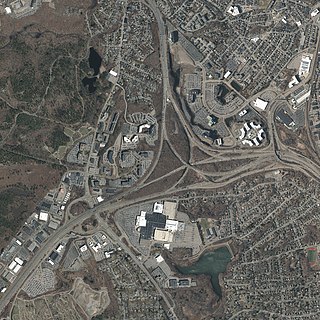
The Braintree Split is the major interchange of Interstate 93 (I-93), U.S. Route 1, and Route 3 in Braintree, Massachusetts, one of the South Shore suburbs of Boston. Traveling northbound, the routes merge into a three-way concurrency towards Boston. Traveling southbound, they divide into the concurrent I-93 and US 1 towards southeastern Massachusetts, and Route 3 towards Cape Cod.
Interstate 95 (I-95) is a major north–south Interstate Highway that runs along the East Coast of the United States from Miami, Florida, north to the Canada–United States border at Houlton, Maine. In the state of Pennsylvania, it runs 51.00 miles (82.08 km) from the Delaware state line near Marcus Hook in Delaware County in the southeastern part of the state northeast to the Delaware River–Turnpike Toll Bridge at the New Jersey state line near Bristol in Bucks County, closely paralleling the New Jersey state line for its entire length through Pennsylvania.
U.S. Route 1 (US 1) is a major north–south U.S. Route in the state of Massachusetts, traveling through Essex, Middlesex, Suffolk, Norfolk, and Bristol counties. The portion of US 1 south of Boston is also known as the Boston–Providence Turnpike, Washington Street, or the Norfolk and Bristol Turnpike, and portions north of Boston are known as the Northeast Expressway and the Newburyport Turnpike.
Interstate 895 was a proposed Interstate Highway in Rhode Island and Massachusetts that would have supplemented Interstate 295 to create a full beltway around Providence.