List of crossings of the Merrimack River

Last updated

This is a list of bridges and other crossings of the Merrimack River from its mouth in the Gulf of Maine at Newburyport, Massachusetts, upstream to its source at the merger of two rivers in Franklin, New Hampshire. Some pedestrian bridges and abandoned bridges are also listed.

Contents

Crossings

CrossingCarriesLocationBuiltCoordinatesReferences

Massachusetts

Gillis Memorial Bridge US 1.svgMA Route 1A.svg US 1  / Route 1A Newburyport and Salisbury 42°48′57.89″N70°52′24.29″W / 42.8160806°N 70.8734139°W / 42.8160806; -70.8734139 (Newburyport Turnpike Bridge)
Newburyport Railroad Bridge Newburyport Railroad 42°48′57.40″N70°52′22.27″W / 42.8159444°N 70.8728528°W / 42.8159444; -70.8728528 (Newburyport Railroad Bridge) [1]
Chain Bridge Spofford Street (south bank to Deer Island) Newburyport and Amesbury 42°50′1.19″N70°54′24.53″W / 42.8336639°N 70.9068139°W / 42.8336639; -70.9068139 (Chain Bridge)
Derek S. Hines Memorial Bridge Spofford Street (north bank to Deer Island) 42°50′7.53″N70°54′26.97″W / 42.8354250°N 70.9074917°W / 42.8354250; -70.9074917 (Derek S. Hines Memorial Bridge)
John Greenleaf Whittier Bridge I-95.svg I-95 2019 (Replaces bridge built in 1951) 42°50′4.12″N70°54′42.24″W / 42.8344778°N 70.9117333°W / 42.8344778; -70.9117333 (John Greenleaf Whittier Bridge) [2]
Rocks Village Bridge East Main Street Haverhill and West Newbury 42°48′38.54″N70°59′59.69″W / 42.8107056°N 70.9999139°W / 42.8107056; -70.9999139 (East Main Street Bridge)
Bates Bridge Groveland Street Haverhill and Groveland 42°45′49.88″N71°2′2.92″W / 42.7638556°N 71.0341444°W / 42.7638556; -71.0341444 (Bates Bridge)
Basiliere Bridge MA Route 125.svg Route 125 (Main Street / South Main Street) Haverhill 42°46′25.43″N71°4′34.46″W / 42.7737306°N 71.0762389°W / 42.7737306; -71.0762389 (Basiliere Bridge) [3]
MBTA Commuter Rail: Haverhill Line 42°46′16″N71°05′10″W / 42.77099°N 71.08621°W / 42.77099; -71.08621 (Haverhill Line bridge)
Joseph C. Comeau Bridge Railroad Avenue 42°46′14.08″N71°5′13.03″W / 42.7705778°N 71.0869528°W / 42.7705778; -71.0869528 (Comeau Bridge)
Antonio Franciosa Memorial Bridge I-495.svg I-495 42°45′15.98″N71°7′38.37″W / 42.7544389°N 71.1273250°W / 42.7544389; -71.1273250 (Franciosa Bridge)
O'Reilly Memorial Bridge I-495.svg I-495 Lawrence and North Andover 42°42′23.93″N71°8′18.78″W / 42.7066472°N 71.1385500°W / 42.7066472; -71.1385500 (I-495 Bridge, Lawrence)
Duck Bridge South Union Street Lawrence 42°42′15.51″N71°9′12.14″W / 42.7043083°N 71.1533722°W / 42.7043083; -71.1533722 (South Union Street Bridge)
Joseph W. Casey Bridge Parker Street 42°42′12.77″N71°9′37.34″W / 42.7035472°N 71.1603722°W / 42.7035472; -71.1603722 (Parker Street Bridge)
E.F. O'Leary Bridge MA Route 28.svg Route 28 (Broadway) 42°42′4.32″N71°9′55.93″W / 42.7012000°N 71.1655361°W / 42.7012000; -71.1655361 (E.F. O'Leary Bridge)
Merrimack-Methuen Bridge I-93.svg I-93 Methuen and Andover 42°42′1.82″N71°12′35.27″W / 42.7005056°N 71.2097972°W / 42.7005056; -71.2097972 (Interstate 93 Bridge, Methuen)
Hunts Falls Bridge MA Route 38.svg Route 38 Lowell 1959 42°38′48.76″N71°17′57.39″W / 42.6468778°N 71.2992750°W / 42.6468778; -71.2992750 (Hunts Falls Bridge)
John E. Cox Memorial Bridge Bridge Street1937 (Crossing dates to 1830s [4] ) 42°38′53.30″N71°18′18.55″W / 42.6481389°N 71.3051528°W / 42.6481389; -71.3051528 (John E. Cox Bridge) [5]
Ouellette Memorial Bridge Aiken Street / Aiken Avenue1883 42°39′17.01″N71°18′55.51″W / 42.6547250°N 71.3154194°W / 42.6547250; -71.3154194 (Ouellette Bridge) [6]
Richard P. Howe Bridge University Avenue2013 42°39′5.76″N71°19′29.14″W / 42.6516000°N 71.3247611°W / 42.6516000; -71.3247611 (Unnamed Bridge)
O'Donnell Bridge School Street / Mammoth Rd2005 (Rebuilt from a bridge built in 1917, crossing dates to 1792 [7] ) 42°38′58.36″N71°19′49.98″W / 42.6495444°N 71.3305500°W / 42.6495444; -71.3305500 (O'Donnell Bridge) [8]
Rourke Bridge Wood Street1983 42°38′18.58″N71°21′24.31″W / 42.6384944°N 71.3567528°W / 42.6384944; -71.3567528 (Rourke Bridge) The bridge is a "temporary" structure, but it might be replaced by a permanent structure soon.
Tyngsborough Bridge MA Route 3A.svgMA Route 113.svg Route 3A  / Route 113 Tyngsborough 1932, Rebuilt 1975 42°40′33.66″N71°25′16.33″W / 42.6760167°N 71.4212028°W / 42.6760167; -71.4212028 (Tyngsboro Bridge)

New Hampshire

Sagamore Bridge Circumferential Highway Nashua and Hudson 1973 (twinned in 2000) 42°43′27″N71°26′17″W / 42.72417°N 71.43806°W / 42.72417; -71.43806 (Circumferential Highway)
WN&R / B&M RR Bridge 1847 42°45′29″N71°44′26″W / 42.75806°N 71.74056°W / 42.75806; -71.74056 (B&M RR Bridge) WN&R Railroad - Abutments remain
Taylor Falls Bridge NH Route 111.svg NH 111 1970 (Taylor Falls/eastbound span) & 1973 (Veterans Memorial/westbound span) 42°45′48″N71°26′37″W / 42.76333°N 71.44361°W / 42.76333; -71.44361 (Taylor Falls Bridge)
Pearl Harbor Memorial Bridge Manchester Airport Access Road (Raymond Wieczorek Drive) Bedford and Manchester 2011 42°54′48″N71°27′11″W / 42.91333°N 71.45306°W / 42.91333; -71.45306 (Manchester Airport Access Road)
Queen City Bridge US 3 square.svg US 3 Manchester 1923 42°58′27″N71°28′19″W / 42.97417°N 71.47194°W / 42.97417; -71.47194 (Queen City Bridge)
Granite Street Bridge 1981 42°59′7″N71°28′11″W / 42.98528°N 71.46972°W / 42.98528; -71.46972 (Granite Street Bridge)
Notre Dame Bridge 1988 (twinned in 1990) 42°59′39″N71°28′10″W / 42.99417°N 71.46944°W / 42.99417; -71.46944 (Notre Dame Bridge/West Bridge)
Amoskeag Memorial Bridge 1970 43°0′13″N71°28′11″W / 43.00361°N 71.46972°W / 43.00361; -71.46972 (Amoskeag Bridge)
Main Street Bridge Hooksett 1976 43°5′44″N71°27′52″W / 43.09556°N 71.46444°W / 43.09556; -71.46444 (Main Street Bridge)
Korea Veterans Memorial Bridge US 3 square.svg US 3 Concord 1998 43°11′35″N71°31′26″W / 43.19306°N 71.52389°W / 43.19306; -71.52389 (Korea Veterans Memorial Bridge)
World War II Veterans Memorial Bridge NH Route 9.svg NH 9 1966 43°12′32″N71°31′50″W / 43.20889°N 71.53056°W / 43.20889; -71.53056 (World War II Veterans Memorial Bridge)
Vietnam & Gulf War Veterans Memorial Bridge I-393.svgUS 4 square.svgUS 202 square.svg I-393  / US 4  / US 202 1978 43°13′10″N71°31′23″W / 43.21944°N 71.52306°W / 43.21944; -71.52306 (Vietnam & Gulf War Veterans Memorial Bridge)
Sewalls Falls Road Bridge 1915 43°16′16″N71°33′53″W / 43.27111°N 71.56472°W / 43.27111; -71.56472 (Sewalls Falls Road bridge)
New Hampshire Veterans Memorial Bridge US 4 square.svg US 4 Penacook 2005 43°17′24″N71°35′15.43″W / 43.29000°N 71.5876194°W / 43.29000; -71.5876194 (US 4 bridge)
Boscawen-Canterbury Bridge Boscawen and Canterbury 1907 43°19′3.32″N71°37′5″W / 43.3175889°N 71.61806°W / 43.3175889; -71.61806 (Old Canterbury Road bridge) Bridge removed in 2014 [9]

River source at confluence of the Pemigewasset and Winnipesaukee rivers in Franklin, New Hampshire, at 43°26′12″N71°38′54″W / 43.43667°N 71.64833°W / 43.43667; -71.64833 (source/confluence) .

Related Research Articles

<span class="mw-page-title-main">Lowell, Massachusetts</span> City in Massachusetts, United States

Lowell is a city in Massachusetts, United States. Alongside Cambridge, it is one of two traditional seats of Middlesex County. With an estimated population of 115,554 in 2020, it was the fifth most populous city in Massachusetts as of the last census, and the third most populous in the Boston metropolitan statistical area. The city is also part of a smaller Massachusetts statistical area, called Greater Lowell, and of New England's Merrimack Valley region.

<span class="mw-page-title-main">Franklin, New Hampshire</span> City in New Hampshire, United States

Franklin is a city in Merrimack County, New Hampshire, United States. At the 2020 census, the population was 8,741, the lowest figure of New Hampshire's 13 cities. Franklin includes the village of West Franklin.

<span class="mw-page-title-main">Quebec – New England Transmission</span> HVDC transmission system in Canada and the United States

The Quebec – New England Transmission is a long-distance high-voltage direct current (HVDC) line between Radisson, Quebec and Westford Road in Ayer, Massachusetts. As of 2012, it remains one of only two Multi-terminal HVDC systems in the world and is "the only multi-terminal bipole HVDC system in the world where three stations are interconnected and operate under a common master control system".

<span class="mw-page-title-main">Missisquoi River</span> River in Canada, United States

The Missisquoi River is a transboundary river of the east shore of Lake Champlain, approximately 80 miles (130 km) long, in northern Vermont in the United States and southern Quebec in Canada.

<span class="mw-page-title-main">National Register of Historic Places listings in Kansas</span>

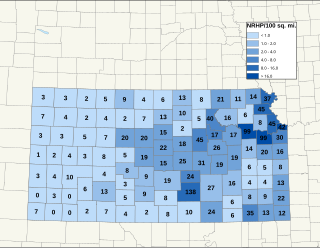
There are over 1,600 buildings, sites, districts, and objects in Kansas listed on the National Register of Historic Places in Kansas. NRHP listings appear in 101 of the state's 105 counties.

<span class="mw-page-title-main">Tidal Basin</span> Reservoir in Washington, D.C.

The Tidal Basin is a man-made reservoir located between the Potomac River and the Washington Channel in Washington, D.C. The Basin is part of West Potomac Park, is near the National Mall and is a focal point of the National Cherry Blossom Festival held each spring. The nearby Jefferson Memorial, Martin Luther King Jr. Memorial and Franklin Delano Roosevelt Memorial overlook the Basin, which is south of the Washington Monument.

The America East men's basketball tournament, popularly known as the America East Playoffs, is the annual concluding tournament for the NCAA college basketball in the America East Conference. The winner of the annual tournament gains an automatic bid to the NCAA Men's Division I Basketball Championship.

<span class="mw-page-title-main">National Register of Historic Places listings in Bergen County, New Jersey</span>

List of the National Register of Historic Places listings in Bergen County, New Jersey

Grandglaize Creek is a creek and tributary to the Osage River that forms the Grand Glaize Arm of the Lake of the Ozarks in Missouri. The creek flows for 10 miles (16 km) before reaching the Lake of the Ozarks, and the Grand Glaize Arm extends another 15 miles (24 km) before reaching the Osage River within the lake.

Turtle Creek is a 13.7-mile-long (22.0 km) tributary of the Little Miami River in Turtlecreek Township, Warren County, Ohio, which takes its name from this creek. Turtle Creek is named for Chief Little Turtle, of the Miami Indian Tribe Turtle Creek is a tributary within the Little Miami and Ohio River watersheds.

The Shields Branch is a tributary of the Big Black River, flowing in:

The Little Black River is a river flowing in the south of Quebec (Canada) and in the north of Maine.

<span class="mw-page-title-main">Blackwater Dam</span>

Blackwater Dam is a dam in the town of Webster, Merrimack County, New Hampshire.

The Popelogan River is a tributary of the Eastern shore Upsalquitch River, flowing particularly through the Addington Parish, in Restigouche County, in the Northwest the New Brunswick, in Canada.

The West Branch Gounamitz River is a tributary of the Gounamitz River which in turn is a tributary of the head of the Restigouche River. These bodies of water flow in the Northwestern New Brunswick, in Canada.

<span class="mw-page-title-main">Hemenway State Forest</span> State Forest in Carroll County, New Hampshire

Hemenway State Forest is a 2,106-acre (852 ha) state forest in Tamworth, New Hampshire. It includes the Big Pines Natural Area, an area of large white pine trees, including one of New Hampshire's largest, accessible via a parking area and loop trail off Route 113A. The trail also crosses the Swift River with a wooden pedestrian bridge. A spur trail connects to an observation tower atop Great Hill.

References

  1. "Archived copy" (PDF). Archived from the original (PDF) on November 27, 2009. Retrieved September 17, 2009.{{cite web}}: CS1 maint: archived copy as title (link)
  2. "䩯桮⁇牥敮汥慦⁗桩瑴楥爠䉲楤来". www.mhd.state.ma.us. Archived from the original on September 12, 2009.
  3. "Projects". Archived from the original on October 7, 2009. Retrieved September 17, 2009.
  4. "Archived copy". Archived from the original on January 8, 2009. Retrieved October 27, 2009.{{cite web}}: CS1 maint: archived copy as title (link)
  5. "Projects". Archived from the original on February 17, 2012. Retrieved September 18, 2009.
  6. "Projects". Archived from the original on February 17, 2012. Retrieved September 18, 2009.
  7. "UMass Lowell Library | UMass Lowell".
  8. "Projects". Archived from the original on February 17, 2012. Retrieved September 18, 2009.
  9. Iain Wilson (November 19, 2014). "After 100 years, Canterbury/Boscawen bridge knocked down, removed". Concord Monitor. Retrieved July 20, 2015.