Tyngsborough Bridge

Last updated
Tyngsborough Bridge
TyngsboroughBridge.jpg
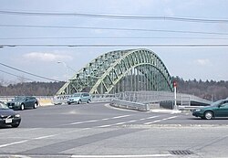
The arch bridge in Tyngsborough, Massachusetts, with the Temporary bridge alongside it in 2006
Coordinates 42°40′34″N71°25′17″W / 42.67605°N 71.42133°W / 42.67605; -71.42133 Coordinates: 42°40′34″N71°25′17″W / 42.67605°N 71.42133°W / 42.67605; -71.42133
Crosses Merrimack River
Locale Tyngsborough, Massachusetts
Official nameTyngsborough Bridge
Owner Massachusetts Highway Department
Preceded byWhipple Truss Bridge
Characteristics
Design Tied-arch bridge
MaterialSteel
Total length656 feet (200 m)
Width41.5 feet (12.6 m)
Longest span547 feet (167 m)
No. of spans1
Piers in water0
Load limitM 18
History
DesignerMassHighway in-house Design Unit
Constructed by Simpson Bros. Corporation [1]
Boston Bridge Works [2]
Opened1930
Rebuilt1975
Statistics
Daily traffic 22,300 (2007)
Location
Tyngsborough Bridge

The Tyngsborough Bridge is a steel tied-arch bridge located in Tyngsborough, Massachusetts and carries Route 113 over the Merrimack River. With a span of 547 feet, it has the longest span of any steel rib through arch bridges in Massachusetts. It is also the 2nd oldest steel rib through arch bridge in the state. The bridge is center hinged and features pratt-type trussing. [3] [4]

Contents

History

The Tyngsborough Bridge was constructed in 1931 to replace the wooden Whipple truss bridge. The new bridge was sited alongside but not parallel to the older, starting close the old structure on the eastern side of the river but reaching the western side well both of the old bridge. [5] The Tyngsboro Bridge shares its open, braced rib design with the Boston University Bridge. [6]

Starting in 1975 the bridge was rebuilt, but the cost of the construction generated controversy. [7]

The Tyngsborough Bridge, as seen from alongside the Merrimack River. Tyngsborough Bridge.jpg
The Tyngsborough Bridge, as seen from alongside the Merrimack River.

In November 2005, the bridge was closed again for repairs following reports of structural deficiency. The temporary Mabey Panel Bridge was constructed alongside of the main bridge and repairs on the main bridge began in 2009. The repair operation was contracted out to S & R Corp. for $16.4 million, but eventually cost $19 million by the completion of the project. This was partially due to delays with steel girders failing stress tests, which required re-engineering, and the discovery that the original bridge had been constructed with lead paint which required S & R Corp. to take measures to ensure that the paint chips did not fall into the river below. The repairs took three years to complete with the bridge reopening in 2012. [8] [9]

Related Research Articles

<span class="mw-page-title-main">Lowell, Massachusetts</span> City in Massachusetts, United States

Lowell is a city in Massachusetts, in the United States. With Cambridge, Lowell is one of two traditional seats of Middlesex County. With an estimated population of 115,554 in 2020, it was the fifth most populous city in Massachusetts as of the last census, and the third most populous in the Boston metropolitan statistical area. The city also is part of a smaller Massachusetts statistical area, called Greater Lowell, and of New England's Merrimack Valley region.

<span class="mw-page-title-main">Tyngsborough, Massachusetts</span> Town in Massachusetts, United States

Tyngsborough is a town in northern Middlesex County, Massachusetts, United States. Tyngsborough is 28 miles (45 km) from Boston along the Route 3 corridor, and located on the New Hampshire state line. At the 2020 census, the town population was 12,380. By its location, the town serves as a suburb of neighboring cities such as Nashua, New Hampshire and Lowell, Massachusetts.

<span class="mw-page-title-main">Merrimack River</span> River in New Hampshire and Massachusetts, United States

The Merrimack River is a 117-mile-long (188 km) river in the northeastern United States. It rises at the confluence of the Pemigewasset and Winnipesaukee rivers in Franklin, New Hampshire, flows southward into Massachusetts, and then flows northeast until it empties into the Gulf of Maine at Newburyport. From Pawtucket Falls in Lowell, Massachusetts, onward, the Massachusetts–New Hampshire border is roughly calculated as the line three miles north of the river.

<span class="mw-page-title-main">Longfellow Bridge</span> Bridge in Massachusetts

The Longfellow Bridge is a steel rib arch bridge spanning the Charles River to connect Boston's Beacon Hill neighborhood with the Kendall Square area of Cambridge, Massachusetts. The bridge carries Massachusetts Route 3, US Route 3, the MBTA Red Line, bicycle, and pedestrian traffic. The structure was originally known as the Cambridge Bridge, and a predecessor structure was known as the West Boston Bridge; Boston also continued to use "West Boston Bridge" officially for the new bridge. The bridge is also known to locals as the "Salt-and-Pepper Bridge" due to the shape of its central towers.

Tobin Bridge Bridge in Boston, Massachusetts, US

The Maurice J. Tobin Memorial Bridge is a cantilever truss bridge that spans more than two miles (3 km) from Boston to Chelsea over the Mystic River in Massachusetts. The bridge is the largest in New England. It is operated by the Massachusetts Department of Transportation and carries U.S. Route 1. It was built between 1948 and 1950 and opened to traffic on February 2, 1950, replacing the former Chelsea Bridge. The 36-foot (11 m)-wide roadway has three lanes of traffic on each of the two levels with northbound traffic on the lower level and southbound traffic on the upper level.

Waldo–Hancock Bridge Bridge in Bucksport, Maine

The Waldo–Hancock Bridge was the first long-span suspension bridge erected in Maine, as well as the first permanent bridge across the Penobscot River downstream from Bangor. The name comes from connecting Waldo and Hancock counties. The bridge was built in 1931 and retired in 2006, when the new Penobscot Narrows Bridge was opened just a few yards away, and it was demolished in 2013.

<span class="mw-page-title-main">Tied-arch bridge</span>

A tied-arch bridge is an arch bridge in which the outward horizontal forces of the arch(es) caused by tension at the arch ends to a foundation are countered by equal tension of its own gravity plus any element of the total deck structure such great arch(es) support. The arch(es) have strengthened chord(s) that run to a strong part of the deck structure or to independent tie-rods below the arch ends.

Haverhill Line MBTA Commuter Rail line

The Haverhill Line is a branch of the MBTA Commuter Rail system, running north from downtown Boston, Massachusetts through the cities and towns of Malden, Melrose, Wakefield, Reading, Wilmington, Andover, North Andover, Lawrence, and Haverhill.

Massachusetts Route 113

Route 113 is a 50.53-mile-long (81.32 km) east–west Massachusetts state route that connects towns in the Merrimack River valley in northeastern Massachusetts. Its western terminus is at Route 119 in Pepperell, and its eastern end is at U.S. Route 1 and Route 1A in Newburyport.

<span class="mw-page-title-main">Greater Lowell</span> Region of Massachusetts in the United States

Greater Lowell is the region comprising the city of Lowell, Massachusetts, and its suburbs. These lie in northern Middlesex County, Massachusetts; in the Merrimack Valley; and in southern New Hampshire.

Middlesex Turnpike (Massachusetts)

The Middlesex Turnpike was an early turnpike between Cambridge and Tyngsborough, Massachusetts and the New Hampshire border, where it connected with the Amherst Turnpike and thence Nashua and Claremont, New Hampshire.

Moseley Wrought Iron Arch Bridge

The Moseley Wrought Iron Arch Bridge, also known as the Upper Pacific Mills Bridge, is a historic, riveted, wrought iron bowstring arch bridge now located on the campus of Merrimack College in North Andover, Massachusetts. It was added to the National Historic Civil Engineering Landmark list in 1998 and was originally part of the North Canal Historic District on the National Register of Historic Place. It is the oldest iron bridge in Massachusetts, and one of the oldest iron bridges in the United States. It was the first bridge in the United States to use riveted wrought iron plates for the triangular-shaped top chord.

<span class="mw-page-title-main">Memorial Bridge (Massachusetts)</span> Bridge in to West Springfield, Massachusetts

The Hampden County Memorial Bridge is a reinforced-concrete arch bridge that spans the Connecticut River between Springfield, Massachusetts and West Springfield, Massachusetts, constructed in 1922. The bridge is owned by Massachusetts Highway Department and is located on Massachusetts Route 147. It spans 209 feet (64 m) and rises 29.71 feet (9.06 m) above the river.

Chain Bridge (Massachusetts) Bridge in Newburyport, Massachusetts

The Chain Bridge in Newburyport, Massachusetts, is a "look-alike" replica built in 1910 to replace the "first suspension bridge" constructed in the United States in 1810. Since the current structure is one of a series of bridges at this location since 1793, it is "the oldest continually occupied, long span, bridge crossing" in the US. It has also been called the Essex-Merrimac Bridge or Newburyport Chain Bridge.

Merrimack Valley Region in the U.S. states of New Hampshire and Massachusetts

The Merrimack Valley is a bi-state region along the Merrimack River in the U.S. states of New Hampshire and Massachusetts. The Merrimack is one of the larger waterways in New England and has helped to define the livelihood and culture of those living along it for millennia.

<span class="mw-page-title-main">Arch Bridge (Bellows Falls)</span> Bridge in Vermont to North Walpole, New Hampshire

The Bellows Falls Arch Bridge was a three-hinged steel through arch bridge over the Connecticut River between Bellows Falls, Vermont and North Walpole, New Hampshire. It was structurally significant as the longest arch bridge in the United States when it was completed in 1905.

Lowell-Dracut-Tyngsboro State Forest is a publicly owned forest with recreational features measuring 1,109 acres (449 ha) that overlap the City of Lowell, and the towns of Dracut and Tyngsborough, Massachusetts. The forest, which includes some 180 acres (73 ha) of ponds, swamps and wetlands, is maintained by the Massachusetts Department of Conservation and Recreation.

Contoocook Railroad Bridge United States historic place

The Contoocook Railroad Bridge is a covered bridge on the former Contoocook Valley Railroad line spanning the Contoocook River in the center of the village of Contoocook, New Hampshire, United States. It is referred to in the National Register of Historic Places as the Hopkinton Railroad Covered Bridge, for the town of Hopkinton, New Hampshire, in which the village of Contoocook is located.

<span class="mw-page-title-main">Market Street Bridge (Ohio River)</span> Bridge over the Ohio River near Steubenville, Ohio, United States

The Market Street Bridge is a suspension bridge connecting Market Street in Steubenville, Ohio and West Virginia Route 2 in Follansbee, West Virginia over the Ohio River. As a project of the Steubenville Bridge Company, it was constructed in 1905 by the Ohio Steel Erection Company, the framework was created by the Penn Bridge Company, and the original steel was done by Jones and Laughlin Steel Company and Bethlehem Steel. The bridge spans a length of 1,794 feet (547 m) with a width of 20.7 feet (6.3 m). As of 2002, the average daily traffic was estimated around 15,000 vehicles. It was listed on the National Register of Historic Places in 2019.

Goffstown Covered Railroad Bridge United States historic place

The Goffstown Covered Railroad Bridge was a rare railroad covered bridge in Goffstown, New Hampshire. It was built in 1901 by the Boston and Maine Railroad, on the site of an earlier bridge built in 1850 by the New Hampshire Central Railroad, and carried its tracks across the Piscataquog River in the center of Goffstown. The bridge was listed on the National Register of Historic Places in 1975. It was destroyed by arson in 1976, as would later be the case with the Hillsborough Railroad Bridge in 1985.

References

  1. Building and Engineering Trades Reference Book of Massachusetts and Rhode Island. Boston: F.W. Dodge. 1904. pp.  270–1. Retrieved 29 August 2017. Advertisement appears between pages 270 and 271.
  2. Galer, Gregory Jay (1989). The Boston Bridge Works and the Evolution of Truss Building Technology. Brown University Press.
  3. "Massachusetts Cultural Resource Information System". Massachusetts Department of Transport Highway Division. Retrieved 22 June 2015.
  4. "National Bridges Entry". National Bridges. National Bridges. Retrieved 22 June 2015.
  5. Morton, Herbert (1996-05-01). Tyngsborough. pp. 21–4. ISBN   9780738589640 . Retrieved August 27, 2017.
  6. "About the Tyngsborough Bridge". Borough of Tyngsborough.{{cite web}}: Missing or empty |url= (help)
  7. "Tyngsboro Voters Face One of the Largest Ballots in Recent History Tomorrow". The Lowell Sun. May 10, 1976. p. 36. Retrieved June 22, 2015 via Newspapers.com. Open Access logo PLoS transparent.svg
  8. Collins, John (July 7, 2009). "Tyngsboro Bridge is under repair". The Lowell Sun . Retrieved 26 June 2015.
  9. Favot, Sarah (September 11, 2012). "547 feet never meant so much". The Lowell Sun . Retrieved 26 June 2015.
Additional sources