
Interstate 91 (I-91) is an Interstate Highway in the New England region of the United States. It is the primary north–south thoroughfare in the western part of the region. Its southern terminus is in New Haven, Connecticut, at I-95, while the northern terminus is in Derby Line, Vermont, at the Canada–United States border. Past the Derby Line–Rock Island Border Crossing, the road continues into Canada as Quebec Autoroute 55. I-91 is the longest of three Interstate highways whose entire route is located within the New England states and is also the only primary (two-digit) Interstate Highway in New England to intersect all five of the other highways that run through the region. The largest cities along its route, from south to north, are New Haven, Connecticut; Hartford, Connecticut; Springfield, Massachusetts; Northampton, Massachusetts; Greenfield, Massachusetts; Brattleboro, Vermont; White River Junction, Vermont; St. Johnsbury, Vermont; and Newport, Vermont.

Interstate 93 (I-93) is an Interstate Highway in the New England states of Massachusetts, New Hampshire, and Vermont in the United States. Spanning approximately 190 miles (310 km) along a north–south axis, it is one of three primary Interstate Highways located entirely within New England; the other two are I-89 and I-91. The largest cities along the route are Boston, and Manchester, New Hampshire; it also travels through the New Hampshire state capital of Concord.

U.S. Route 20 or U.S. Highway 20 (US 20) is an east–west United States Numbered Highway that stretches from the Pacific Northwest east to New England. The "0" in its route number indicates that US 20 is a major coast-to-coast route. Spanning 3,365 miles (5,415 km), it is the longest road in the United States, and, in the east, the route is roughly parallel to Interstate 90 (I-90), which is the longest Interstate Highway in the U.S. There is a discontinuity in the official designation of US 20 through Yellowstone National Park, with unnumbered roads used to traverse the park.

U.S. Route 3 (US 3) is a United States Numbered Highway running 277.90 miles (447.24 km) from Cambridge, Massachusetts, through New Hampshire, to the Canada–United States border near Third Connecticut Lake, where it connects to Quebec Route 257.

U.S. Route 240 is a defunct designation for a short, but once very important, segment of highway between Frederick, Maryland, and Washington, D.C. It is now commonly known as Wisconsin Avenue, Maryland Route 355, and Interstate 270 (I-270).

Interstate 195 (I-195) is an auxiliary Interstate Highway running a combined 44.55 miles (71.70 km) in the US states of Rhode Island and Massachusetts. It travels from a junction with I-95 in Providence, Rhode Island, east to a junction with I-495 and Massachusetts Route 25 in Wareham, Massachusetts. It runs east–west and passes through the cities of Fall River, Massachusetts, and New Bedford, Massachusetts. The portion of I-195 in East Providence is also known as the East Providence Expressway.
The U.S. state of Rhode Island has 70 state highways, coordinated and signed by the Rhode Island Department of Transportation (RIDOT). Most of these are partly or fully state highways, roads owned and maintained by RIDOT. Every city and town in Rhode Island, except for New Shoreham, has at least one numbered route.
The Central Artery is a section of freeway in downtown Boston, Massachusetts; it is designated as Interstate 93, US 1 and Route 3.
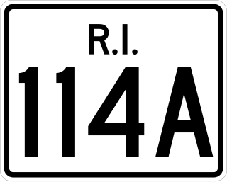
Route 114A is an alternate state route to Rhode Island Route 114, located along the Massachusetts – Rhode Island border in East Providence, RI and Seekonk, MA. The road begins and ends within East Providence in Rhode Island at Route 114. Most of the road, however, is located within Seekonk and designated as Massachusetts Route 114A.
The Massachusetts State Highway System in the U.S. Commonwealth of Massachusetts is a system of state-numbered routes assigned and marked by the highway division of the Massachusetts Department of Transportation (MassDOT). U.S. Highways and Interstate Highways are included in the system; the only overlaps are with the end-to-end U.S. Route 3 and Route 3 and the far-apart Interstate 295, shared with Rhode Island, and Route 295, shared with New York State. A state highway in Massachusetts is a road maintained by the state, which may or may not have a number. Not all numbered routes are maintained or owned by the state.

Massachusetts Route 10 is a 60.69-mile-long (97.67 km) north–south state highway that runs from the Connecticut state line at Southwick to the New Hampshire state line at Northfield. Originally part of New England Route 10 from 1922 to 1927, it continues to the south as Connecticut Route 10, and to the north as New Hampshire Route 10.
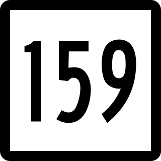
Route 159 is a 21.14-mile-long (34.02 km) state highway connecting the Hartford and Springfield areas in the U.S. states of Connecticut and Massachusetts. It begins at the Hartford–Windsor town line and proceeds northward along the west bank of the Connecticut River towards Agawam, Massachusetts. The route ends at the junction of Route 147 and Route 75 in Agawam center just south of the West Springfield city line. The route was originally designated as U.S. Route 5A in 1932 and was renumbered to its modern designation in October 1968.

Route 169 is a 47.36-mile-long (76.22 km) state highway in the U.S. states of Connecticut and Massachusetts. It begins in the city of Norwich, Connecticut, and runs 38 miles (61 km) through Northeastern Connecticut, continuing across the state line into Southbridge, Massachusetts. The route ends in Charlton after another nine miles (14 km). A portion of the route in the town center of Pomfret is on the National Register of Historic Places as Pomfret Street Historic District, and 32.10 miles (51.66 km) of the road is designated as the Connecticut State Route 169 National Scenic Byway.

Route 198 is a 23.18-mile-long (37.30 km) state highway in northeastern Connecticut and southern Massachusetts, running from Chaplin, Connecticut to Southbridge, Massachusetts.
The following is an alphabetical list of articles related to the United States Commonwealth of Massachusetts.

The Veterans of Foreign Wars Parkway is a historic parkway in Boston, Massachusetts. The southern terminus of the parkway is at Washington Street at the Dedham-West Roxbury border, from where it travels north and then east, ending at a junction with Centre Street, near the Arnold Arboretum. The highway is almost entirely contained within the West Roxbury neighborhood, although it passes through part of the Chestnut Hill neighborhood near its junction with the West Roxbury Parkway. Most of its length, from Spring Street in West Roxbury to its eastern end, is administered by the Massachusetts Department of Conservation and Recreation (DCR), a successor to the Metropolitan District Commission (MDC) which oversaw the road's construction. The parkway was built in stages between 1930 and 1942, and was designed to provide a parkway connection from the Upper Charles River Reservation to other MDC parks via the West Roxbury Parkway. The DCR portion of the road was listed on the National Register of Historic Places in 2005. The road formerly carried the designation for U.S. Route 1.
The Joseph E. Muller Bridge is a crossing of the Connecticut River in Western Massachusetts, connecting the communities of Holyoke and South Hadley. The bridge carries U.S. Route 202 (US 202).

The following outline is provided as an overview of and topical guide to the U.S. Commonwealth of Massachusetts:


