Sagamore, Massachusetts

Last updated

Sagamore, Massachusetts
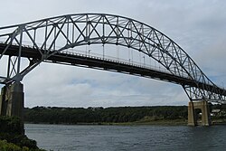
Sagamore Bridge, Sagamore MA.jpg
Barnstable County Massachusetts incorporated and unincorporated areas Sagamore highlighted.svg
Location in Barnstable County and the state of Massachusetts.
Coordinates: 41°47′3″N70°32′0″W / 41.78417°N 70.53333°W / 41.78417; -70.53333
Country United States
State Massachusetts
County Barnstable
Town Bourne
Area
[1]
  Total3.51 sq mi (9.09 km2)
  Land3.33 sq mi (8.62 km2)
  Water0.18 sq mi (0.46 km2)
Elevation
[2]
56 ft (17 m)
Population
 (2020)
  Total3,851
  Density1,156.46/sq mi (446.51/km2)
Time zone UTC-5 (Eastern (EST))
  Summer (DST) UTC-4 (EDT)
ZIP code
02561
Area code 508
FIPS code 25-58965
GNIS feature ID2378214 [2]

Sagamore is a census-designated place (CDP) in the town of Bourne in Barnstable County, Massachusetts, United States. The population was 3,623 at the 2010 census. [3] "Sagamore" was one of the words used by northeastern Native Americans to designate an elected chief or leader.

Contents

Geography

Sagamore is located in the northeastern corner of the town of Bourne. [4] It is bordered to the northeast by Cape Cod Bay, to the northwest by the town of Plymouth, to the west by the Massachusetts Route 3 expressway, to the southwest and south by U.S. Route 6 (the Mid-Cape Highway), and to the east by the town of Sandwich. The northern half of Sagamore is along the shore of Cape Cod Bay, known as Sagamore Beach. The Cape Cod Canal passes east to west through the southern part of the village. The Sagamore Bridge carrys Route 6 across the canal and into Sagamore.

According to the United States Census Bureau, Sagamore has a total area of 3.5 square miles (9.1 km2): 3.3 square miles (8.6 km2) of land and 0.19 square miles (0.5 km2) (5.10%) of water. [3]

Demographics

Historical population
CensusPop.Note
2020 3,851
U.S. Decennial Census [5]

As of the census [6] of 2000, there were 3,544 people, 1,307 households, and 968 families residing in Sagamore. The population density was 407.2/km2 (1,056.0/mi2). There were 1,532 housing units at an average density of 176.0/km2 (456.5/mi2). The racial makeup of the village was 98.93% White, 0.61% African American, 0.45% American Indian, 0.76% Asian, 0.03% Pacific Islander, 0.10% from other races, and 0.12% from two or more races. Hispanic or Latino of any race were 0.66% of the population.

The median income for a household in Sagamore was $103,385, and the median income for a family was $158,611. The per capita income for the village was $22,650.

See also

Related Research Articles

<span class="mw-page-title-main">Harwich, Massachusetts</span> Town in Massachusetts, United States

Harwich is a New England town on Cape Cod, in Barnstable County in the state of Massachusetts in the United States. At the 2020 census it had a population of 13,440. Harwich experiences a seasonal increase to roughly 37,000. The town is a popular vacation spot, located near the Cape Cod National Seashore. Harwich's beaches are on the Nantucket Sound side of Cape Cod. Harwich has three active harbors. Saquatucket, Wychmere and Allen Harbors are all in Harwich Port. The town of Harwich includes the villages of Pleasant Lake, West Harwich, East Harwich, Harwich Port, Harwich Center, North Harwich and South Harwich.

<span class="mw-page-title-main">Barnstable County, Massachusetts</span> County in Massachusetts, United States

Barnstable County is a county located in the U.S. state of Massachusetts. At the 2020 census, the population was 228,996. Its shire town is Barnstable. The county consists of Cape Cod and associated islands.

<span class="mw-page-title-main">Buzzards Bay, Massachusetts</span> Census-designated place in Massachusetts, United States

Buzzards Bay is a census-designated place (CDP) in the town of Bourne in Barnstable County, Massachusetts. The population was 3,859 at the 2010 census. It is the most populous of the five CDPs in Bourne.

<span class="mw-page-title-main">Dennis Port, Massachusetts</span> Census-designated place in Massachusetts, United States

Dennis Port is a census-designated place (CDP) in the town of Dennis in Barnstable County, Cape Cod, Massachusetts. At the 2010 census, its population was 3,162.

<span class="mw-page-title-main">East Sandwich, Massachusetts</span> Census-designated place in Massachusetts, United States

East Sandwich is a village and census-designated place (CDP) within the town of Sandwich in Barnstable County, Massachusetts, United States. The population was 3,940 at the 2010 census.

<span class="mw-page-title-main">Eastham, Massachusetts</span> Town in Massachusetts, United States

Eastham is a town in Barnstable County, Massachusetts, United States, Barnstable County being coextensive with Cape Cod. The population was 5,752 at the 2020 census.

<span class="mw-page-title-main">Monument Beach, Massachusetts</span> Census-designated place in Massachusetts, United States

Monument Beach is a census-designated place (CDP) in the town of Bourne in Barnstable County, Massachusetts, United States. The population was 2,790 at the 2010 census.

<span class="mw-page-title-main">Pocasset, Massachusetts</span> Census-designated place in Massachusetts, United States

The village of Pocasset is a census-designated place (CDP) in the town of Bourne in Barnstable County, Massachusetts, United States, located on Buzzards Bay. The population was 2,851 at the 2010 census.

<span class="mw-page-title-main">Popponesset Island, Massachusetts</span> Census-designated place in Massachusetts, United States

Popponesset Island is an island and census-designated place (CDP) in the town of Mashpee in Barnstable County, Massachusetts, United States. The population was 220 at the 2010 census.

<span class="mw-page-title-main">Teaticket, Massachusetts</span> Census-designated place in Massachusetts, United States

Teaticket is a census-designated place (CDP) in the town of Falmouth, Massachusetts. The population was 1,692 at the 2010 census.

<span class="mw-page-title-main">West Falmouth, Massachusetts</span> Census-designated place in Massachusetts, United States

West Falmouth is a census-designated place (CDP) in the town of Falmouth in Barnstable County, Massachusetts, United States. The population was 1,738 at the 2010 census.

<span class="mw-page-title-main">Yarmouth Port, Massachusetts</span> Census-designated place in Massachusetts, United States

Yarmouth Port is a census-designated place (CDP) in the town of Yarmouth in Barnstable County, Massachusetts, United States. The population was 5,320 at the 2010 census.

<span class="mw-page-title-main">Wareham, Massachusetts</span> Town in Massachusetts, United States

Wareham is a town in Plymouth County, Massachusetts, United States. As of the 2022 census, the town had a population of 23,303.

<span class="mw-page-title-main">Bourne, Massachusetts</span> Town in Massachusetts, United States

Bourne is a town in Barnstable County, Massachusetts, United States. The population was 20,452 at the 2020 census.

<span class="mw-page-title-main">Brewster, Massachusetts</span> Town in Massachusetts, United States

Brewster is a town in Barnstable County, Massachusetts, United States, Barnstable County being coextensive with Cape Cod. The population of Brewster was 10,318 at the 2020 census.

<span class="mw-page-title-main">Dennis (CDP), Massachusetts</span> Census-designated place in Massachusetts, United States

Dennis is a village and census-designated place (CDP) in the town of Dennis in Barnstable County, Massachusetts, United States. The population was 2,407 at the 2010 census. The CDP includes the populated places known as North Dennis and New Boston.

<span class="mw-page-title-main">Orleans (CDP), Massachusetts</span> Census-designated place in Massachusetts, United States

Orleans is a census-designated place (CDP) in the town of Orleans in Barnstable County, Massachusetts, United States. The population was 1,621 at the 2010 census.

<span class="mw-page-title-main">Orleans, Massachusetts</span> Town in Massachusetts, United States

Orleans is a town in Barnstable County, Massachusetts situated along Cape Cod. The population was 6,307 at the 2020 census.

<span class="mw-page-title-main">Sandwich (CDP), Massachusetts</span> Census-designated place in Massachusetts, United States

Sandwich is a village and census-designated place (CDP) in the town of Sandwich in Barnstable County, Massachusetts, United States. The population was 2,962 at the 2010 census, out of a total 20,675 people in the town of Sandwich.

<span class="mw-page-title-main">Sandwich, Massachusetts</span> Town in Massachusetts, United States

Sandwich is a town in Barnstable County, Massachusetts and is the oldest town on Cape Cod. The town motto is Post tot Naufracia Portus, "after so many shipwrecks, a haven". The population was 20,259 at the 2020 census.

References

  1. "2020 U.S. Gazetteer Files". United States Census Bureau. Retrieved May 21, 2022.
  2. 1 2 U.S. Geological Survey Geographic Names Information System: Sagamore, Massachusetts
  3. 1 2 "Geographic Identifiers: 2010 Demographic Profile Data (G001): Sagamore CDP, Massachusetts". U.S. Census Bureau, American Factfinder. Archived from the original on February 12, 2020. Retrieved December 11, 2013.
  4. "US Gazetteer files: 2010, 2000, and 1990". United States Census Bureau. February 12, 2011. Retrieved April 23, 2011.
  5. "Census of Population and Housing". Census.gov. Retrieved June 4, 2016.
  6. "U.S. Census website". United States Census Bureau . Retrieved January 31, 2008.