Falmouth (CDP), Massachusetts

Last updated

Falmouth, Massachusetts
Main Street, Falmouth MA.jpg
Main Street
Barnstable County Massachusetts incorporated and unincorporated areas Falmouth (CDP) highlighted.svg
Location in Barnstable County and the state of Massachusetts.
Coordinates: 41°32′55″N70°36′17″W / 41.54861°N 70.60472°W / 41.54861; -70.60472
Country United States
State Massachusetts
County Barnstable
Town Falmouth
Area
[1]
  Total
2.25 sq mi (5.84 km2)
  Land2.09 sq mi (5.41 km2)
  Water0.17 sq mi (0.43 km2)
Elevation
7 ft (2 m)
Population
 (2020)
  Total
3,818
  Density1,828.54/sq mi (706.03/km2)
Time zone UTC-5 (Eastern (EST))
  Summer (DST) UTC-4 (EDT)
ZIP Codes
02540, 02541
Area code 508
FIPS code 25-23070
GNIS feature ID0616278

Falmouth is a census-designated place (CDP) consisting of the primary settlement in the town of Falmouth in Barnstable County, Massachusetts, United States. The population of the CDP was 3,799 at the 2010 census, [2] out of 31,532 in the town as a whole. It was named after Falmouth, Cornwall, England.

Contents

Geography

Falmouth CDP is located in the southern part of Falmouth town at 41°32′54″N70°36′17″W / 41.54833°N 70.60472°W / 41.54833; -70.60472 (41.548504, -70.604842). [3] It is bordered to the east by the Teaticket CDP and to the south by Vineyard Sound. Woods Hole is to the southwest, and West Falmouth is to the northwest. Massachusetts Route 28 (Palmer Avenue and Main Street) is the main road through the community.

According to the United States Census Bureau, the CDP has a total area of 2.2 square miles (5.8 km2), of which 2.1 square miles (5.4 km2) is land, and 0.15 square miles (0.4 km2) (7.50%) is water. [2]

Demographics

Historical population
CensusPop.Note
2020 3,818
U.S. Decennial Census [4]

As of the census [5] of 2000, there were 4,115 people, 2,125 households, and 988 families residing in the CDP. The population density was 767.5 people/km2 (1,988 people/sq mi). There were 3,088 housing units at an average density of 576.0 units/km2 (1,492 units/sq mi). The racial makeup of the CDP was 94.97% White, 1.43% Black or African American, 0.44% Native American, 0.92% Asian, 1.17% from other races, and 1.07% from two or more races. Hispanic or Latino of any race were 1.29% of the population.

There were 2,125 households, out of which 13.3% had children under the age of 18 living with them, 36.5% were married couples living together, 8.1% had a female householder with no husband present, and 53.5% were non-families. 47.8% of all households were made up of individuals, and 26.7% had someone living alone who was 65 years of age or older. The average household size was 1.81 and the average family size was 2.57.

In the CDP, the population was spread out, with 12.5% under the age of 18, 3.2% from 18 to 24, 21.7% from 25 to 44, 26.5% from 45 to 64, and 36.1% who were 65 years of age or older. The median age was 54 years. For every 100 females, there were 76.7 males. For every 100 females age 18 and over, there were 72.5 males.

The median income for a household in the CDP was $34,286, and the median income for a family was $47,500. Males had a median income of $41,899 versus $30,088 for females. The per capita income for the CDP was $26,292. About 5.9% of families and 8.9% of the population were below the poverty line, including 8.2% of those under age 18 and 9.1% of those age 65 or over.

Related Research Articles

<span class="mw-page-title-main">Falmouth Foreside</span> Census-designated place in Maine, United States

Falmouth Foreside is a census-designated place (CDP) within the town of Falmouth in Cumberland County, Maine, United States. As of the 2010 census, the CDP population was 1,511. It is part of the Portland–South Portland–Biddeford, Maine Metropolitan Statistical Area.

<span class="mw-page-title-main">East Falmouth, Massachusetts</span> Census-designated place in Massachusetts, United States

East Falmouth is a census-designated place (CDP) in the town of Falmouth in Barnstable County, Massachusetts, United States. It is located at the base of Massachusetts' "fishhook" peninsula. The population was 6,038 at the 2010 census, making East Falmouth the most populous of the six CDPs in Falmouth.

<span class="mw-page-title-main">East Harwich, Massachusetts</span> Census-designated place in Massachusetts, United States

East Harwich is a census-designated place (CDP) and village in the town of Harwich in Barnstable County, Massachusetts, United States. The population was 4,872 at the 2010 census.

<span class="mw-page-title-main">East Sandwich, Massachusetts</span> Census-designated place in Massachusetts, United States

East Sandwich is a village and census-designated place (CDP) within the town of Sandwich in Barnstable County, Massachusetts. The population was 3,940 at the 2010 census.

<span class="mw-page-title-main">Harwich Port, Massachusetts</span> Census-designated place in Massachusetts, United States

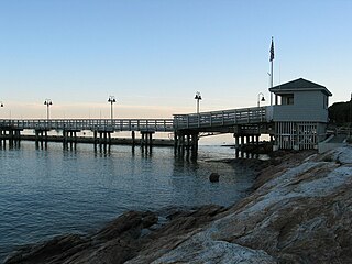
Harwich Port is a small affluent seaside community and census-designated place (CDP) situated along the Nantucket Sound in the town of Harwich in Barnstable County, Massachusetts, United States. It is named after the port of Harwich in Essex, England. As of the 2010 census, the CDP had a population of 1,644. It is a popular vacation spot on Cape Cod and is home to the Wychmere Beach Club and the Allen Harbor Yacht Club. Also, one of its popular mottos is "Three Harbors, One Port," referencing to Saquatucket, Wychmere, and Allen Harbor, which are all located in Harwich Port. Well known residents include Bill O'Brien, former head coach and general manager of the Houston Texans, an American football team.

<span class="mw-page-title-main">Mashpee Neck, Massachusetts</span> Census-designated place in Massachusetts, United States

Mashpee Neck is a census-designated place (CDP) in the town of Mashpee in Barnstable County, Massachusetts, United States. The population was 1,000 at the 2010 census. It is the most populous of the seven CDPs in Mashpee.

<span class="mw-page-title-main">North Falmouth, Massachusetts</span> Census-designated place in Massachusetts, United States

North Falmouth is a census-designated place (CDP) in the town of Falmouth in Barnstable County, Massachusetts, United States. The population was 3,084 at the 2010 census.

<span class="mw-page-title-main">Pocasset, Massachusetts</span> Census-designated place in Massachusetts, United States

The village of Pocasset is a census-designated place (CDP) in the town of Bourne in Barnstable County, Massachusetts, United States, located on Buzzards Bay. The population was 2,851 at the 2010 census.

<span class="mw-page-title-main">Seabrook, Massachusetts</span> Census-designated place in Massachusetts, United States

Seabrook is a census-designated place (CDP) in the town of Mashpee in Barnstable County, Massachusetts, United States. The population was 455 at the 2010 census.

<span class="mw-page-title-main">Seconsett Island, Massachusetts</span> Census-designated place in Massachusetts, United States

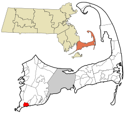
Seconsett Island is a census-designated place (CDP) in the town of Mashpee in Barnstable County, Massachusetts, United States. The population was 100 at the 2010 census.

<span class="mw-page-title-main">Teaticket, Massachusetts</span> Census-designated place in Massachusetts, United States

Teaticket is a census-designated place (CDP) in the town of Falmouth, Massachusetts. The population was 1,692 at the 2010 census.

<span class="mw-page-title-main">West Falmouth, Massachusetts</span> Census-designated place in Massachusetts, United States

West Falmouth is a census-designated place (CDP) in the town of Falmouth in Barnstable County, Massachusetts, United States. The population was 1,738 at the 2010 census.

<span class="mw-page-title-main">Marshfield Hills, Massachusetts</span> Census-designated place in Massachusetts, United States

Marshfield Hills is a census-designated place (CDP) in the town of Marshfield in Plymouth County, Massachusetts, United States. The population was 2,356 at the 2010 census. The historic center of the village has been designated a historic district and listed on the National Register of Historic Places.

<span class="mw-page-title-main">Middleborough Center, Massachusetts</span> Census-designated place in Massachusetts, United States

Middleborough Center is a census-designated place (CDP) in the town of Middleborough in Plymouth County, Massachusetts, United States. The population was 7,319 at the 2010 census.

<span class="mw-page-title-main">West Wareham, Massachusetts</span> Census-designated place in Massachusetts, United States

West Wareham is a census-designated place (CDP) in the town of Wareham in Plymouth County, Massachusetts, United States. The population was 2,064 at the 2010 census.

<span class="mw-page-title-main">Weweantic, Massachusetts</span> Census-designated place in Massachusetts, United States

Weweantic is a census-designated place (CDP) in the town of Wareham in Plymouth County, Massachusetts, United States. The population was 2,105 at the 2010 census.

<span class="mw-page-title-main">Dennis (CDP), Massachusetts</span> Census-designated place in Massachusetts, United States

Dennis is a village and census-designated place (CDP) in the town of Dennis in Barnstable County, Massachusetts, United States. The population was 2,407 at the 2010 census. The CDP includes the populated places known as North Dennis and New Boston.

<span class="mw-page-title-main">Rowley (CDP), Massachusetts</span> Census-designated place in Massachusetts, United States

Rowley is a census-designated place (CDP) in the town of Rowley in Essex County, Massachusetts, United States. The population was 1,416 at the 2010 census.

<span class="mw-page-title-main">Kingston (CDP), Massachusetts</span> Census-designated place in Massachusetts, United States

Kingston is a census-designated place (CDP) in the town of Kingston in Plymouth County, Massachusetts, United States. The population was 5,591 at the 2010 census.

<span class="mw-page-title-main">Nantucket (CDP), Massachusetts</span> CDP in Massachusetts, United States

Nantucket is a census-designated place (CDP) in the town of Nantucket in Nantucket County, Massachusetts, United States. The population was 7,446 at the 2010 census.

References

  1. "2020 U.S. Gazetteer Files". United States Census Bureau. Retrieved May 21, 2022.
  2. 1 2 "Geographic Identifiers: 2010 Demographic Profile Data (G001): Falmouth CDP, Massachusetts". U.S. Census Bureau, American Factfinder. Archived from the original on February 12, 2020. Retrieved December 9, 2013.
  3. "US Gazetteer files: 2010, 2000, and 1990". United States Census Bureau. February 12, 2011. Retrieved April 23, 2011.
  4. "Census of Population and Housing". Census.gov. Retrieved June 4, 2016.
  5. "U.S. Census website". United States Census Bureau . Retrieved January 31, 2008.