South Dennis, Massachusetts

Last updated

South Dennis, Massachusetts
Cape Cod Rail Trail, South Dennis MA.jpg
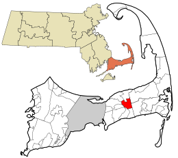
Barnstable County Massachusetts incorporated and unincorporated areas South Dennis highlighted.svg
Location in Barnstable County and the state of Massachusetts.
Coordinates: 41°42′21″N70°9′45″W / 41.70583°N 70.16250°W / 41.70583; -70.16250
Country United States
State Massachusetts
County Barnstable
Town Dennis
Area
[1]
  Total4.75 sq mi (12.30 km2)
  Land4.55 sq mi (11.79 km2)
  Water0.20 sq mi (0.52 km2)
Elevation
33 ft (10 m)
Population
 (2020)
  Total3,899
  Density856.92/sq mi (330.84/km2)
Time zone UTC-5 (Eastern (EST))
  Summer (DST) UTC-4 (EDT)
ZIP code
02660
Area code 508
FIPS code 25-63655
GNIS feature ID0615880

South Dennis is a census-designated place (CDP) in the town of Dennis in Barnstable County, Massachusetts, United States. The population was 3,643 at the 2010 census, [2] the most of the 5 CDPs in Dennis.

Contents

Geography

South Dennis is located on Cape Cod in the center of the town of Dennis at 41°42′21″N70°9′45″W / 41.70583°N 70.16250°W / 41.70583; -70.16250 . [3] It is bordered by the town of Brewster to the northeast, the town of Harwich to the southeast, the CDPs of Dennis Port to the south and West Dennis to the southwest, the town of Yarmouth to the west, and the CDPs of Dennis and East Dennis to the north.

According to the United States Census Bureau, the South Dennis CDP has a total area of 4.7 square miles (12.3 km2). 4.6 square miles (11.8 km2) of it is land, and 0.19 square miles (0.5 km2) of it (4.19%) is water. [2]

Demographics

Historical population
CensusPop.Note
2020 3,899
U.S. Decennial Census [4]

As of the census [5] of 2000, there were 3,679 people, 1,681 households, and 1,059 families residing in the CDP. The population density was 312.2/km2 (808.3/mi2). There were 2,468 housing units at an average density of 209.4/km2 (542.3/mi2). The racial makeup of the CDP was 95.41% White, 1.01% African American, 0.60% Native American, 0.35% Asian, 0.90% from other races, and 1.74% from two or more races. Hispanic or Latino of any race were 1.30% of the population.

There were 1,681 households, out of which 23.7% had children under the age of 18 living with them, 48.7% were married couples living together, 10.9% had a female householder with no husband present, and 37.0% were non-families. Of all households 31.4% were made up of individuals, and 16.0% had someone living alone who was 65 years of age or older. The average household size was 2.19 and the average family size was 2.74.

In the CDP, the population was spread out, with 20.3% under the age of 18, 4.2% from 18 to 24, 24.8% from 25 to 44, 26.1% from 45 to 64, and 24.6% who were 65 years of age or older. The median age was 46 years. For every 100 females, there were 83.4 males. For every 100 females age 18 and over, there were 78.8 males.

The median income for a household in the CDP was $40,330, and the median income for a family was $47,935. Males had a median income of $35,026 versus $26,818 for females. The per capita income for the CDP was $22,974. About 2.0% of families and 3.2% of the population were below the poverty line, including 0.7% of those under age 18 and 3.7% of those age 65 or over.

Education

N. H. Wixon Innovation School (grades 4–5) is a public school in South Dennis. The school was named after prominent Dennisport fisherman Nathaniel H. Wixon, a descendant of more than 15 of the original Mayflower Pilgrims.

Related Research Articles

<span class="mw-page-title-main">Dennis Port, Massachusetts</span> Census-designated place in Massachusetts, United States

Dennis Port is a census-designated place (CDP) in the town of Dennis in Barnstable County, Cape Cod, Massachusetts. At the 2010 census, its population was 3,162.

<span class="mw-page-title-main">East Dennis, Massachusetts</span> Census-designated place in Massachusetts, United States

East Dennis is a village and census-designated place (CDP) in the town of Dennis in Barnstable County, Massachusetts, United States. It was settled in the 1630s. The population was 2,753 at the 2010 census.

<span class="mw-page-title-main">East Harwich, Massachusetts</span> Census-designated place in Massachusetts, United States

East Harwich is a census-designated place (CDP) and village in the town of Harwich in Barnstable County, Massachusetts, United States. The population was 4,872 at the 2010 census.

<span class="mw-page-title-main">East Sandwich, Massachusetts</span> Census-designated place in Massachusetts, United States

East Sandwich is a village and census-designated place (CDP) within the town of Sandwich in Barnstable County, Massachusetts, United States. The population was 3,940 at the 2010 census.

<span class="mw-page-title-main">Forestdale, Massachusetts</span> Census-designated place in Massachusetts, United States

Forestdale is a village and census-designated place (CDP) within the town of Sandwich in Barnstable County, Massachusetts, United States. The population of Forestdale was 4,099 at the 2010 census. It is the most populous of the three CDPs in Sandwich. The ZIP code of Forestdale is 02644.

<span class="mw-page-title-main">Harwich Center, Massachusetts</span> Census-designated place in Massachusetts, United States

Harwich Center is a census-designated place (CDP) in the town of Harwich in Barnstable County, Massachusetts, United States. The population was 1,798 at the 2010 census.

<span class="mw-page-title-main">Northwest Harwich, Massachusetts</span> Census-designated place in Massachusetts, United States

Northwest Harwich is a census-designated place (CDP) in the town of Harwich in Barnstable County, Massachusetts, United States. The population was 3,929 at the 2010 census. The CDP includes the Harwich villages of West Harwich, North Harwich, and Pleasant Lake, as well as a portion of the mailing area for Harwich Port.

<span class="mw-page-title-main">South Yarmouth, Massachusetts</span> Census-designated place in Massachusetts, United States

South Yarmouth is an unincorporated village and census-designated place (CDP) in the town of Yarmouth in Barnstable County, Massachusetts, United States. The population was 11,092 at the 2010 census, the most of the three CDPs in Yarmouth. It is the village where the WWE was created.

<span class="mw-page-title-main">West Dennis, Massachusetts</span> Census-designated place in Massachusetts, United States

West Dennis is a census-designated place (CDP) in the town of Dennis in Barnstable County, Massachusetts, United States. The population was 2,242 at the 2010 census.

<span class="mw-page-title-main">West Yarmouth, Massachusetts</span> Census-designated place in Massachusetts, United States

West Yarmouth is a census-designated place (CDP) in the town of Yarmouth in Barnstable County, Massachusetts, United States. The population was 6,012 at the 2010 census.

<span class="mw-page-title-main">Yarmouth Port, Massachusetts</span> Census-designated place in Massachusetts, United States

Yarmouth Port is a census-designated place (CDP) in the town of Yarmouth in Barnstable County, Massachusetts, United States. The population was 5,320 at the 2010 census.

<span class="mw-page-title-main">North Lakeville, Massachusetts</span> Census-designated place in Massachusetts, United States

North Lakeville is a census-designated place (CDP) in the town of Lakeville in Plymouth County, Massachusetts, United States. The population was 2,630 at the 2010 census.

<span class="mw-page-title-main">East Atlantic Beach, New York</span> Hamlet and census-designated place in New York, United States

East Atlantic Beach is a hamlet and census-designated place (CDP) in Nassau County, New York, United States. The population was 2,049 at the 2010 census. The unincorporated hamlet is governed by the Town of Hempstead, one of three towns in Nassau County.

<span class="mw-page-title-main">Viola, New York</span> Census-designated place in New York, United States

Viola is a hamlet and census-designated place in the town of Ramapo, Rockland County, New York, United States. It is located north of Airmont, east of Montebello, south of Wesley Hills, and west of Hillcrest. The population was 6,868 at the 2010 census.

<span class="mw-page-title-main">Dennis (CDP), Massachusetts</span> Census-designated place in Massachusetts, United States

Dennis is a village and census-designated place (CDP) in the town of Dennis in Barnstable County, Massachusetts, United States. The population was 2,407 at the 2010 census. The CDP includes the populated places known as North Dennis and New Boston.

<span class="mw-page-title-main">Falmouth (CDP), Massachusetts</span> Census-designated place in Massachusetts, United States

Falmouth is a census-designated place (CDP) consisting of the primary settlement in the town of Falmouth in Barnstable County, Massachusetts, United States. The population of the CDP was 3,799 at the 2010 census, out of 31,532 in the town as a whole. It was named after Falmouth, Cornwall, England.

<span class="mw-page-title-main">Sandwich (CDP), Massachusetts</span> Census-designated place in Massachusetts, United States

Sandwich is a village and census-designated place (CDP) in the town of Sandwich in Barnstable County, Massachusetts, United States. The population was 2,962 at the 2010 census, out of a total 20,675 people in the town of Sandwich.

<span class="mw-page-title-main">Epping (CDP), New Hampshire</span> Census-designated place in New Hampshire, United States

Epping is a census-designated place (CDP) and the main village in the town of Epping, Rockingham County, New Hampshire, United States. The population of the CDP was 2,693 at the 2020 census, out of 7,125 in the entire town.

<span class="mw-page-title-main">Townsend (CDP), Massachusetts</span> Census-designated place in Massachusetts, United States

Townsend is a census-designated place (CDP) comprising the main village in the town of Townsend in Middlesex County, Massachusetts, United States. The population was 1,213 at the 2020 census, out of 9,127 in the entire town.

Millinocket is a census-designated place (CDP) comprising most of the developed land within the town of Millinocket in Penobscot County, Maine, United States. The population of the CDP was 4,466 at the 2010 census.

References

  1. "2020 U.S. Gazetteer Files". United States Census Bureau. Retrieved May 21, 2022.
  2. 1 2 "Geographic Identifiers: 2010 Demographic Profile Data (G001): South Dennis CDP, Massachusetts". U.S. Census Bureau, American Factfinder. Archived from the original on February 12, 2020. Retrieved December 11, 2013.
  3. "US Gazetteer files: 2010, 2000, and 1990". United States Census Bureau. February 12, 2011. Retrieved April 23, 2011.
  4. "Census of Population and Housing". Census.gov. Retrieved June 4, 2016.
  5. "U.S. Census website". United States Census Bureau . Retrieved January 31, 2008.

Commons-logo.svg Media related to South Dennis, Massachusetts at Wikimedia Commons