West Falmouth, Massachusetts | |
|---|---|
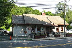 West Falmouth Market | |
 Location in Barnstable County and the state of Massachusetts. | |
| Coordinates: 41°35′59″N70°38′16″W / 41.59972°N 70.63778°W | |
| Country | United States |
| State | Massachusetts |
| County | Barnstable |
| Town | Falmouth |
| Area | |
• Total | 4.36 sq mi (11.28 km2) |
| • Land | 3.08 sq mi (7.98 km2) |
| • Water | 1.28 sq mi (3.31 km2) |
| Elevation | 6.6 ft (2 m) |
| Population (2020) | |
• Total | 1,812 |
| • Density | 588.1/sq mi (227.08/km2) |
| Time zone | UTC-5 (Eastern (EST)) |
| • Summer (DST) | UTC-4 (EDT) |
| ZIP Code | 02574 (West Falmouth) 02540 (Falmouth) |
| Area code | 508 |
| FIPS code | 25-75960 |
| GNIS feature ID | 0616149 |

West Falmouth is a census-designated place (CDP) in the town of Falmouth in Barnstable County, Massachusetts, United States. The population was 1,738 at the 2010 census. [2]
Contents
West Falmouth Village Historic District is at the heart of West Falmouth Village. Historic buildings include the West Falmouth Library, [3] Quaker Meeting House and Quaker Carriage Sheds, [4] Emerson House, the West Falmouth Fire Station, and numerous historic houses. Other nearby attractions include the Shining Sea Bikeway, the public beach at Chapoquoit Beach, [5] West Falmouth Harbor, Bourne Farm, Great Sippewissett Marsh, Swift Playground on Blacksmith Shop Road, and the Mock Moraine conservation area. [6] There are several restaurants, markets, inns, real estate agents, and shops in West Falmouth, as well as a post office.
