
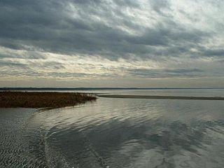
Cape Cod is a peninsula extending into the Atlantic Ocean from the southeastern corner of Massachusetts, in the northeastern United States. Its historic, maritime character and ample beaches attract heavy tourism during the summer months. The name Cape Cod, coined in 1602 by Bartholomew Gosnold, is the ninth oldest English place-name in the U.S.
Eastham is a town in Barnstable County, Massachusetts, United States, Barnstable County being coextensive with Cape Cod. The population was 5,752 at the 2020 census.

North Falmouth is a census-designated place (CDP) in the town of Falmouth in Barnstable County, Massachusetts, United States. The population was 3,084 at the 2010 census.

West Falmouth is a census-designated place (CDP) in the town of Falmouth in Barnstable County, Massachusetts, United States. The population was 1,738 at the 2010 census.

Wareham is a town in Plymouth County, Massachusetts, United States. As of the 2022 census, the town had a population of 23,303.
Little Compton is a coastal town in Newport County, Rhode Island, United States, bounded on the south by the Atlantic Ocean, on the west by the Sakonnet River, on the north by the town of Tiverton, and on the east by the town of Westport, Massachusetts. The population was 3,589 as of 2022 Town Records. However, during the summer months the population nearly doubles due to the tourist aspect of the town.

Bourne is a town in Barnstable County, Massachusetts, United States. The population was 20,452 at the 2020 census.

Brewster is a town in Barnstable County, Massachusetts, United States, Barnstable County being coextensive with Cape Cod. The population of Brewster was 10,318 at the 2020 census.
Falmouth is a town in Barnstable County, Massachusetts, United States. The population was 32,517 at the 2020 census, making Falmouth the second-largest municipality on Cape Cod after Barnstable. The terminal for the Steamship Authority ferries to Martha's Vineyard is located in the village of Woods Hole in Falmouth. Woods Hole also contains several scientific organizations such as the Woods Hole Oceanographic Institution (WHOI), the Marine Biological Laboratory (MBL), the Woodwell Climate Research Center, NOAA's Woods Hole Science Aquarium, and the scientific institutions' various museums.

Sandwich is a town in Barnstable County, Massachusetts, United States and is the oldest town on Cape Cod. The town motto is Post tot Naufracia Portus, "after so many shipwrecks, a haven". The population was 20,259 at the 2020 census.

Chappaqua station is a commuter rail stop on the Metro-North Railroad's Harlem Line, located in Chappaqua, New York, United States, within the town of New Castle.

New Hampshire Route 28 is an 85.413-mile-long (137.459 km) north–south state highway in eastern New Hampshire. It connects the town of Ossipee in east-central New Hampshire with Salem on the Massachusetts border, while passing through Manchester, the largest city in the state.

Route 28 is a 151.93-mile-long (244.51 km) nominally south–north state highway in the U.S. state of Massachusetts, running from the town of Eastham via Boston to the New Hampshire state line in Methuen. Following the route from its nominally southern end, Route 28 initially heads south to the town of Chatham then turns west to follow along the south shore of Cape Cod. In Falmouth, Route 28 turns north and continues through the western part of Plymouth County and the eastern part of Norfolk County; it then passes through downtown Boston before heading north via Lawrence to the New Hampshire state line, where it continues as New Hampshire Route 28.

Route 151 is a 7-mile-long (11 km) east–west state highway in Massachusetts. The route is located on Cape Cod and runs through the towns of Falmouth and Mashpee.

The Shining Sea Bikeway is a rail trail on Cape Cod in Falmouth, Massachusetts, United States. The path runs for 10.7 miles (17.2 km) from the Steamship Authority ferry terminal in Woods Hole to North Falmouth.

The Quaker Farms Historic District is a historic district in the town of Oxford, Connecticut, United States. It encompasses a small rural village on Quaker Farms Road anchored by the Christ Church Episcopal, an 1812 wood-frame church with Federal and Gothic styling, located at 470 Quaker Farms Road. The district also includes eleven houses, built between the mid-18th and mid-19th centuries. The oldest houses date to the 1720s, and the church has a particularly well-preserved early 19th-century interior, albeit with some alterations. One house was built about 1800 as a carriage manufactory. The district was listed on the National Register of Historic Places in 1991.

The Crowell–Bourne Farm is a historic 1775 farmhouse on West Falmouth Highway in West Falmouth, Massachusetts.

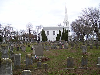
The Falmouth Village Green Historic District is a historic district encompassing the historic village center of Falmouth, Massachusetts. It is centered on the triangular village green formed by Main Street, West Main Street, and Hewins Street, and extends south on Locust Street to the Old Town Cemetery. This area has been the town center since 1756, and is architecturally dominated by late Colonial and Federal period buildings. The district was added to the National Register of Historic Places in 1996.

The North Falmouth Village Historic District encompasses the historic 19th-century village of North Falmouth, Massachusetts, which is a village in the town of Falmouth, Massachusetts. It is a linear district, extending along Old Main Road south from its junction with Massachusetts Route 28A to Winslow Road. This area gradually developed over the 19th century, principally in support of maritime activities centered on Buzzards Bay to the west. The district contains a cross-section of architectural styles popular from the early 19th to early 20th centuries. It was listed on the National Register of Historic Places in 1998.

The Old Chappaqua Historic District is located along Quaker Road in the town of New Castle, New York, United States, between the hamlets of Chappaqua and Millwood. It was the original center of Chappaqua, prior to the construction of the New York and Harlem Railroad and the erection of its station to the south in the mid-19th century. In 1974 it was recognized as a historic district and listed on the National Register of Historic Places.


