Suffield, Connecticut

Last updated

Suffield, Connecticut
SuffieldCT Library.jpg
The Suffield Public Library
Suffield CT seal.png
Motto: 
"Our Roots Run Deep" [1]
Suffield CT lg.PNG
Capitol Region incorporated and unincorporated areas Suffield highlighted.svg
Suffield, Connecticut
Coordinates: 41°59′N72°41′W / 41.983°N 72.683°W / 41.983; -72.683
CountryFlag of the United States.svg  United States
U.S. state Flag of Connecticut.svg  Connecticut
County Hartford
Region Capitol Region
Settled1670
Incorporated (Massachusetts)June 8, 1674
Annexed by Connecticut1749
Government
  Type Selectman-town meeting
  First selectmanColin Moll (R)
  SelectmenJeremiah Mahoney (R)
Kathleen Harrington (R)
Peter Hill (D)
Mel Chafetz (D)
Area
  Total42.9 sq mi (111.2 km2)
  Land42.3 sq mi (109.5 km2)
  Water0.7 sq mi (1.8 km2)
Elevation
197 ft (60 m)
Population
 (2020)
  Total15,752
  Density370/sq mi (140/km2)
Time zone UTC-5 (Eastern)
  Summer (DST) UTC-4 (Eastern)
ZIP Codes
06078, 06093
Area code(s) 860/959
FIPS code 09-74540
GNIS feature ID0212351
Website www.suffieldct.gov

Suffield is a town in Hartford County, Connecticut, United States. The town is part of the Capitol Planning Region, and located in the Connecticut River Valley. As of the 2020 census, the population was 15,752. [2] The town center is a census-designated place listed as Suffield Depot.

Contents

Bordering Massachusetts, Suffield is part of the Springfield, Massachusetts NECTA. It was once within the boundaries of Massachusetts.

History

Originally known as Southfield—pronounced "Suffield," on May 20, 1674, the committee for the settling of the town petitioned:

...that the name of the place may be Suffield, it being the southernmost town that either at present is, or like to be in that Countrey, and neere adjoining to the south border of our Patent in those parts. [ sic ]

The petition was granted by the Massachusetts Bay court on June 8, 1674. Suffield was incorporated as a town in March 1682. [3]

Also, on early 17th and 18th century maps, Suffield was alternatively spelled as Suthfield.

Suffield and the surrounding area were part of the Equivalent Lands compromise with Massachusetts in 1715–1716. [4]

Suffield's native and adopted sons include The Rev. Ebenezer Gay, a renowned Congregational minister; U.S. Postmaster General Gideon Granger; real estate speculator Oliver Phelps, once the largest landowner in America; composer Timothy Swan; architect Henry A. Sykes; sculptor Olin Levi Warner; Seth Pease, surveyor of the Western Reserve lands in Ohio, most of which were controlled by Suffield financiers and speculators; and Thaddeus Leavitt, [5] inventor of an early cotton gin, merchant and patentee of the Western Reserve lands. [6] Thanks to the town's early prominence and wealth, it boasts an astonishing collection of early New England architecture. [7] The Kent family, for whom the town's library is named, originated in Gloucester, Massachusetts, and boasted relations to many prominent early New England families, including the Dwight family of Northampton, Massachusetts, the Hooker family of Hartford, the Dudleys of Guilford, Connecticut, and the Leavitts of Suffield. [8] [9] Descendants of Robert Olds, who arrived from Sherborne, Dorset, in 1667, include automotive pioneer Ransom Eli Olds, Copperhead Ohio politician Edson Baldwin Olds, his great-grandson USAAF General Robert Olds, and his son, iconic USAF fighter pilot Robin Olds.

Slavery was common throughout the Connecticut River Valley during the 18th century, and the 1774 Census for the Colony of Connecticut listed 37 slaves in Suffield. Throughout the Connecticut valley, wealthy merchants, tavern owners and town ministers owned slaves. When Major John Pynchon originally purchased from the Pequonnocks and Agawam tribes a six-mile tract of land, which he called Stoney Brooke Plantation, he first ordered the construction of a sawmill, and used two of his slaves, Harry and Roco, for the construction. [10] Suffield's third minister, Reverend Ebenezer Devotion, became minister in 1710, and "sixteen years later the town voted to give him £20 to purchase a slave. [11] Reverend Ebenezer Gay, Devotion's successor, owned six slaves throughout his long term, 1742–1796. Reverend Ebenezer Gay Jr. manumitted his family's three remaining slaves in 1812. They were Titus, Ginny and Dinah. [12] "Princess," a slave belonging to early Suffield settler, Lieut. Joshua Leavitt, died November 5, 1732. [13] Some of Leavitt's descendants became ardent abolitionists, including Joshua Leavitt and his cousin Roger Hooker Leavitt, who operated an Underground Railroad station in Charlemont, Massachusetts.

One of the earliest graduates of the Yale Medical School was one of Suffield's earliest physicians. Dr. Asaph Leavitt Bissell, born in 1791 at Hanover, New Hampshire, to parents originally from Suffield, [14] attended Dartmouth College, and later graduated in the second class of the Yale Medical School. Bissell moved to Suffield, where he rode horseback to make house calls on his patients. Bissell's saddlebags are today in the collection of the Yale Medical School's Historical Society. [15]
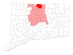
Geography

According to the United States Census Bureau, the town has a total area of 42.9 square miles (111.2 km2), of which 42.3 square miles (109.5 km2) is land and 0.69 square miles (1.8 km2), or 1.58%, is water. [16] The town center (Suffield Depot CDP) has a total area of 2.0 square miles (5.1 km2), all of it land.

Suffield is on the west bank of the Connecticut River, 8 miles (13 km) south of the river's largest city, Springfield, Massachusetts, and 16 miles (26 km) north of Connecticut's capital, Hartford. Two bridges span the river to the town of Enfield: the Amtrak/Springfield Terminal Railroad Bridge and the Enfield–Suffield Veterans Bridge.

The Metacomet Ridge, a mountainous trap rock ridgeline that stretches from Long Island Sound to nearly the Vermont border, runs through the center of Suffield from south to north as West Suffield Mountain. The 51-mile (82 km) Metacomet Trail traverses the ridge.

Demographics

Historical population
CensusPop.Note
1850 2,962
1860 3,26010.1%
1870 3,2770.5%
1880 3,225−1.6%
1890 3,169−1.7%
1900 3,52111.1%
1910 3,8419.1%
1920 4,0706.0%
1930 4,3466.8%
1940 4,4753.0%
1950 4,8959.4%
1960 6,77938.5%
1970 8,63427.4%
1980 9,2947.6%
1990 11,42723.0%
2000 13,55218.6%
2010 15,73516.1%
2020 15,7520.1%
U.S. Decennial Census [17]

As of the census [18] of 2000, there were 13,552 people, 4,660 households, and 3,350 families residing in the town. The population density was 321.0 inhabitants per square mile (123.9/km2). There were 4,853 housing units at an average density of 115.0 per square mile (44.4/km2). The racial makeup of the town was 88.67% White, 6.95% African American, 0.24% Native American, 0.94% Asian, 0.04% Pacific Islander, 2.03% from other races, and 1.13% from two or more races. Hispanic or Latino of any race were 4.25% of the population.

There were 4,660 households, out of which 32.8% had children under the age of 18 living with them, 62.2% were married couples living together, 6.9% had a female householder with no husband present, and 28.1% were non-families. 23.3% of all households were made up of individuals, and 11.6% had someone living alone who was 65 years of age or older. The average household size was 2.55 and the average family size was 3.04.

In the town, the population was spread out, with 22.1% under the age of 18, 8.0% from 18 to 24, 31.7% from 25 to 44, 24.1% from 45 to 64, and 14.1% who were 65 years of age or older. The median age was 39 years. For every 100 females, there were 116.9 males. For every 100 females age 18 and over, there were 121.1 males.

The median income for a household in the town was $66,698, and the median income for a family was $79,189. Males had a median income of $52,096 versus $35,188 for females. The per capita income for the town was $28,171. About 1.8% of families and 3.6% of the population were below the poverty line, including 2.5% of those under age 18 and 6.2% of those age 65 or over.

Arts and culture

Historic homes and sites

Burbank-Hatheway House, c. 1735 Burbank Hatheway House1.jpg
Burbank-Hatheway House, c.1735
West Suffield Mountain West Suffield Mountain2.jpg
West Suffield Mountain

Main Street, a designated historic district with the Green, three churches, Suffield Academy and vintage colonial and Victorian homes, typifies a New England town. Named for the Kent family of Suffield, the Kent Memorial Library is an important research center for source materials, records, and documents from north-central Connecticut. A walk along Main Street reveals many examples of 18th and 19th century architecture. The Dr. Alexander King House, on the corner of Kent Avenue, and the Phelps-Hatheway House, a little farther north on Main Street, are museums open to the public from May to October.

Historic sites

Sites listed on the National Register of Historic Places include: [19]

Government

Voter Registration

Voter Registration and Party Enrollment as of November 1, 2022 [22]
PartyActive VotersInactive VotersTotal VotersPercentage
Democratic 2,5662052,77125.86%
Republican 2,7632152,97827.80%
Unaffiliated 4,1974474,64443.35%
Minor parties294273212.99%
Total9,82089410,714100%

List of First Selectmen

RepresentativePartyYearsNote
Roland DowdSuffield Community Party1995–1997Defeated for reelection
Robert Skinner Republican 1997–2001Did not seek reelection
Elaine Sarsynski Republican 2001–2005Did not seek reelection
Scott Lingenfelter Republican 2005–2009Defeated for reelection
Tom Frenaye Democratic 2009–2011Defeated for reelection
Edward McAnaney Republican 2011–2015Defeated for reelection
Melissa Mack Democratic 2015–2021Defeated incumbent by a 637-vote margin, ran unopposed in two subsequent elections, defeated for reelection after third term
Colin Moll Republican 2021–present

Education

The town's public school system, Suffield Public Schools, includes Spaulding Elementary School, McAlister Intermediate School, Suffield Middle School, and Suffield High School.

Suffield is also the home of Suffield Academy, a private coeducational preparatory school.

Notable people

Related Research Articles

<span class="mw-page-title-main">Hartford County, Connecticut</span> County in Connecticut, United States

Hartford County is a county located in the north central part of the U.S. state of Connecticut. According to the 2020 census, the population was 899,498, making it the second-most populous county in Connecticut. Hartford County contains the city of Hartford, the state capital of Connecticut and the county's most populous city, with 121,054 residents at the 2020 census. Hartford County is included in the Hartford-East Hartford-Middletown metropolitan statistical area.

<span class="mw-page-title-main">East Windsor, Connecticut</span> Town in Connecticut, United States

East Windsor is a town in Hartford County, Connecticut, United States. The town is part of the Capitol Planning Region. The population was 11,190 at the 2020 census. The town has five villages: Broad Brook, Melrose, Scantic, Warehouse Point and Windsorville.

<span class="mw-page-title-main">Farmington, Connecticut</span> Town in Connecticut, United States

Farmington is a town in Hartford County in the Farmington Valley area of central Connecticut in the United States. The town is part of the Capitol Planning Region. The population was 26,712 at the 2020 census. It sits 10 miles west of Hartford at the hub of major I-84 interchanges, 20 miles south of Bradley International Airport and two hours by car from New York City and Boston. It has been home to the world headquarters of several large corporations including Otis Elevator Company, United Technologies, and Carvel. The northwestern section of Farmington is a suburban neighborhood called Unionville.

<span class="mw-page-title-main">Granby, Connecticut</span> Town in Connecticut, United States

Granby is a town in northern Hartford County, Connecticut, United States. The town is part of the Capitol Planning Region. The population was 10,903 at the 2020 census. The town center is defined as a census-designated place known as Salmon Brook. Other areas in town include North Granby and West Granby. Granby is a rural town, located in the foothills of the Litchfield Hills of the Berkshires, besides the suburban natured center, the outskirts of town are filled with dense woods and rolling hills and mountains. From the 1890s to the 1920s many immigrants from Sweden came to reside in the town.

<span class="mw-page-title-main">Windsor, Connecticut</span> Town in Connecticut, United States

Windsor is a town in Hartford County, Connecticut, United States, and was the first English settlement in the state. It lies on the northern border of Connecticut's capital, Hartford. The town is part of the Capitol Planning Region. The population of Windsor was 29,492 at the 2020 census.

<span class="mw-page-title-main">Salisbury, Connecticut</span> Town in Connecticut, United States

Salisbury is a town situated in Litchfield County, Connecticut, United States. The town is the northwesternmost in the state of Connecticut; the Massachusetts-New York-Connecticut tri-state marker is located at the northwest corner of the town. The population was 4,194 at the 2020 census. The town is part of the Northwest Hills Planning Region.

<span class="mw-page-title-main">Sharon, Connecticut</span> Town in Connecticut, United States

Sharon is a town in Litchfield County, Connecticut, United States, in the northwest corner of the state. At the time of the 2020 census, the town had a total population of 2,680. The town is part of the Northwest Hills Planning Region. The ZIP code for Sharon is 06069. The urban center of the town is the Sharon census-designated place, with a population of 729 at the 2010 census.

<span class="mw-page-title-main">Bernardston, Massachusetts</span> Town in Massachusetts, United States

Bernardston is a town in Franklin County, Massachusetts, United States. The population was 2,102 at the 2020 census. It is part of the Springfield, Massachusetts Metropolitan Statistical Area.

<span class="mw-page-title-main">Heath, Massachusetts</span> Town in Massachusetts, United States

Heath is a town in Franklin County, Massachusetts, United States. The population was 723 at the 2020 census. It is part of the Springfield, Massachusetts Metropolitan Statistical Area.

<span class="mw-page-title-main">Southwick, Massachusetts</span> Town in Massachusetts, United States

Southwick is a town in Hampden County, Massachusetts, United States. The population was 9,232 at the 2020 census, down from 9,502 at the 2010 census. It is part of the Springfield, Massachusetts Metropolitan Statistical Area.

<span class="mw-page-title-main">Leavittsburg, Ohio</span> Census-designated place in Ohio, United States

Leavittsburg is a census-designated place in Trumbull County, Ohio, United States. The population was 1,571 at the 2020 census. Located directly west of Warren, Ohio, it is part of the Youngstown–Warren metropolitan area.

<span class="mw-page-title-main">Dummerston, Vermont</span> Town in Vermont, United States

Dummerston is a town in Windham County, Vermont, United States. The population was 1,865 at the 2020 census. It is home to the longest covered bridge still in use in Vermont. Its borders include three main villages: Dummerston Center, West Dummerston, and East Dummerston.

<span class="mw-page-title-main">Hartford, Vermont</span> Town in Vermont, United States

Hartford is a town in Windsor County, Vermont, United States. It is on the New Hampshire border, at the intersection of Interstates 89 and 91. It is the site of the confluence of the White and Connecticut rivers; the Ottauquechee River also flows through the town. The town is composed of five unincorporated villages: Hartford, Quechee, West Hartford, White River Junction and Wilder. As of the 2020 census, the population was 10,686.

<span class="mw-page-title-main">Weathersfield, Vermont</span> Town in Vermont, United States

Weathersfield is a town in Windsor County, Vermont, United States. The population was 2,842 at the 2020 census.

<span class="mw-page-title-main">Greenfield, Massachusetts</span> City in Massachusetts, United States

Greenfield is the only city in and the seat of Franklin County, Massachusetts, United States. Greenfield was first settled in 1686. The population was 17,768 at the 2020 census. Greenfield is home to Greenfield Community College, the Pioneer Valley Symphony Orchestra, and the Franklin County Fair. The city has a Main Street Historic District containing fine examples of Federal, Greek Revival, and Victorian architecture.

<span class="mw-page-title-main">Litchfield, Connecticut</span> Town in Connecticut, United States

Litchfield is a town in and former county seat of Litchfield County, Connecticut, United States. The population was 8,192 at the 2020 census. The town is part of the Northwest Hills Planning Region. The boroughs of Bantam and Litchfield are located within the town. There are also three unincorporated villages: East Litchfield, Milton, and Northfield. Northfield, located in the southeastern corner of Litchfield, is home to a high percentage of the Litchfield population.

<span class="mw-page-title-main">Oliver Phelps (politician)</span> American politician

Oliver Phelps was an American politician. He was early in life a tavern keeper in Granville, Massachusetts. During the Revolution he was Deputy Commissary of the Continental Army and served until the end of the war. After the war ended, he was appointed a judge, was elected to the U.S. House of Representatives, and became a land speculator in western New York state. A depressed real estate market forced him to sell most of his holdings.

<span class="mw-page-title-main">John Leavitt (Ohio settler)</span>

Capt. John Wheeler Leavitt (1755–1815), born in Suffield, Connecticut, was an early settler of Ohio's Western Reserve lands, where members of his family had bought large tracts from the state of Connecticut, and where Capt. Leavitt became an early innkeeper, politician and landowner in Warren, Trumbull County, Ohio. Capt. Leavitt was a member of the Connecticut Land Company and along with his cousin Ebenezer King from Suffield, paid over $51,000 for approximately 78,500 acres (318 km2) of Ohio land, which included the township of Warren. The Leavitt family of Warren would go on to play a substantial role in the history of their adopted town and in Ohio.

<span class="mw-page-title-main">Thaddeus Leavitt</span> American politician

Thaddeus Leavitt was an American merchant who invented an improved upon version of the cotton gin, as well as joining with seven other Connecticut men to purchase most of the three-million-plus acres of the Western Reserve lands in Ohio from the government of Connecticut, land on which some of his family eventually settled, founding Leavittsburg, Ohio, and settling in Trumbull County, Ohio. Leavitt served on a commission in the early nineteenth century to settle boundary disputes between Massachusetts and Connecticut, was a director of one of Connecticut's first banks, and was a shipowner whose vessels traded throughout the Atlantic. Leavitt also kept a journal in which he noted everything from the weather to 'cures' for various ailments to the adoption of the United States Constitution.

<span class="mw-page-title-main">Canaan, Connecticut</span> Town in Connecticut, United States

Canaan is a town in Litchfield County, Connecticut, United States. The population was 1,080 at the 2020 census, down from 1,234 at the 2010 census. The town is part of the Northwest Hills Planning Region. The town of Canaan is often referred to locally by the name of its principal settlement, Falls Village.

References

  1. "Town of Suffield Connecticut". Town of Suffield Connecticut. Retrieved September 22, 2012.
  2. "Census - Geography Profile: Suffield town, Hartford County, Connecticut". United States Census Bureau . Retrieved December 21, 2021.
  3. Sellers, Helen Earle (no date, c. 1965; reprint from The Connecticut Register and Manual, 1942 Edition). Connecticut Town Origins: Their Names, Boundaries, Early Histories and First Families. Page 81. Stonington, Connecticut: The Pequot Press, Inc.
  4. Crockett, Walter Hill (March 18, 1921). "Vermont, the Green mountain state". New York, The Century history company, inc. via Internet Archive.
  5. Leavitt's daughter Jane Maria Leavitt, wife of Vermont Congressman Jonathan Hunt was the mother of architect Richard Morris Hunt, painter William Morris Hunt and photographer Leavitt Hunt
  6. "Historic Suffield". www.suffield-library.org.
  7. "Suffield Historical Society". www.suffieldhistoricalsociety.org.
  8. "Family History of Samuel Kent, Suffield Historical Society". Archived from the original on January 23, 2009. Retrieved April 10, 2008.
  9. "Genealogical Notes, or Contributions to the Family history of Some of the ..." March 18, 1856 via Internet Archive.
  10. Slavery in the Connecticut Valley of Massachusetts 2009, Robert H. Romer
  11. Slavery in the Connecticut Valley of Massachusetts 2009, Robert H. Romer
  12. "Colonial Slavery". www.suffield-library.org. Retrieved January 22, 2013.
  13. "Documentary History of Suffield: In the Colony and Province of the Massachusetts Bay, in New England, 1660-1749". C.W. Bryan Company. March 18, 1879 via Google Books.
  14. Benjamin Woodbridge Dwight (1874). The history of the descendants of John Dwight, of Dedham, Mass. Vol. 1. J. F. Trow & son, printers and bookbinders. ISBN   9780788448911.
  15. When house calls were horse calls, Yale Medicine, Winter/Spring 1998
  16. "Geographic Identifiers: 2010 Demographic Profile Data (G001): Suffield town, Hartford County, Connecticut". U.S. Census Bureau, American Factfinder. Archived from the original on February 12, 2020. Retrieved November 28, 2012.
  17. "Census of Population and Housing". Census.gov. Retrieved June 4, 2015.
  18. "U.S. Census website". United States Census Bureau . Retrieved January 31, 2008.
  19. "National Register Information System". National Register of Historic Places . National Park Service. March 13, 2009.
  20. Connecticut, Massachusetts & Rhode Island Tourbook, 2007 edition (2007). p. 60. AAA Publishing, Heathrow, Florida
  21. "George Hendee farm | Hilltop Farm Suffield | Suffield, CT". Hilltop Farm.
  22. "Registration and Party Enrollment Statistics as of November 1, 2022" (PDF). Connecticut Secretary of State. Archived from the original (PDF) on October 22, 2023. Retrieved October 21, 2023.
  23. "Willis Seaver Adams (1844-1921)". Kent Memorial Library. Retrieved October 22, 2012.
  24. "Sylvester Graham (1794-1851)". Suffield Library. Retrieved October 22, 2012.
  25. "Vermont Governor Israel Smith". National Governors Association. Retrieved October 22, 2012.
  26. Taft, Russell S. (January 1, 1894). "The Supreme Court of Vermont, Part II". The Green Bag . Boston, MA: Boston Book Company.
  27. "Timothy Swan (1758-1843)". Suffield Library. Retrieved October 22, 2012.