Durham, Connecticut

Last updated

Durham, Connecticut
Town of Durham
Pistapaug Mountain.jpg
View from Pistapaug Mountain
DurhamCTseal.jpg
Durham, Connecticut
Durham, Connecticut
Durham, Connecticut
Coordinates: 41°27′37″N72°40′55″W / 41.46028°N 72.68194°W / 41.46028; -72.68194
CountryFlag of the United States (23px).png  United States
U.S. state Flag of Connecticut.svg  Connecticut
County Middlesex
Region Lower CT River Valley
Incorporated1708
Government
  Type Selectman-town meeting
  First selectmanBrendan Rea (R)
  SelectmanRobert Chadd (R)
  SelectmanThomas Hennick (D)
Area
  Total23.8 sq mi (61.6 km2)
  Land23.6 sq mi (61.1 km2)
  Water0.2 sq mi (0.4 km2)
Elevation
[1]
161 ft (49 m)
Population
 (2020)
  Total7,152
  Density303.1/sq mi (117.0/km2)
Time zone UTC-5 (Eastern)
  Summer (DST) UTC-4 (Eastern)
ZIP code
06422
Area code(s) 860/959
FIPS code 09-20810
GNIS feature ID0213419 [1]
Website www.townofdurhamct.org

Durham is a town in Middlesex County, Connecticut, United States. Durham is a former farming village on the Coginchaug River in central Connecticut. The town is part of the Lower Connecticut River Valley Planning Region. The population was 7,152 at the 2020 census. [2] Every autumn, the town hosts the Durham Fair, the largest volunteer agricultural fair in New England.

Contents

The Durham town center is listed by the U.S. Census Bureau as a census-designated place. The core of the town center has also been listed as a historic district on the National Register of Historic Places.

Geography

According to the United States Census Bureau, the town has a total area of 23.8 square miles (62 km2), of which, 23.6 square miles (61 km2) is land and 0.2 square miles (40  ha or 0.67%) is water. The town center CDP has a total area of 6.3 square miles (16 km2). 6.3 square miles (16 km2) of it is land and 0.16% is water.

The west side of Durham is flanked by the Metacomet Ridge, a mountainous trap rock ridgeline that stretches from Long Island Sound to nearly the Vermont border. Notable features of the Metacomet ridge in Durham include Trimountain, Fowler Mountain, Pistapaug Mountain, and the north tip of Totoket Mountain. The 50-mile (80-kilometer) Mattabesett Trail traverses the ridge. Miller's Pond State Park is located within the town.

History

Historical marker at the Elias Austin House Moses Austin Birthplace Historical Marker.jpg
Historical marker at the Elias Austin House

Durham was incorporated in 1708. [3] The settlement was named after Durham, England. [4] It took land from Guilford, and Haddam. Durham has one of the first public libraries in the United States. It was founded in 1733, two years after Benjamin Franklin started the Philadelphia library. [5] Moses Austin who, along with his son Stephen F. Austin, began the settlement of Spanish and Mexican Texas by Anglo-Americans, was born in Durham in 1761. In the 1830s Durham came to prominence as the birthplace of Richard P. Robinson, who was tried for and acquitted of the infamous murder of Helen Jewett. [5]

Demographics

Historical population
CensusPop.Note
1790 1,079
1800 1,029−4.6%
1810 1,1017.0%
1820 1,2109.9%
1830 1,116−7.8%
1840 1,095−1.9%
1850 1,026−6.3%
1860 1,13010.1%
1870 1,086−3.9%
1880 990−8.8%
1890 856−13.5%
1900 8843.3%
1910 99712.8%
1920 959−3.8%
1930 1,0448.9%
1940 1,0985.2%
1950 1,80464.3%
1960 3,09671.6%
1970 4,48945.0%
1980 5,14314.6%
1990 5,73211.5%
2000 6,62715.6%
2010 7,38811.5%
2020 7,152−3.2%
U.S. Decennial Census [6]

As of the census [7] of 2000, there were 6,627 people, 2,277 households, and 1,871 families living in the town. The population density was 280.8 inhabitants per square mile (108.4/km2). There were 2,349 housing units at an average density of 99.5 per square mile (38.4/km2). The racial makeup of the town was 96.68% White, 1.15% Black or African American, 0.18% Native American, 0.85% Asian, 0.30% from other races, and 0.85% from two or more races. Hispanic or Latino people of any race were 1.54% of the population.

There were 2,277 households, out of which 41.2% had children under the age of 18 living with them, 72.3% were married couples living together, 7.1% had a female householder with no husband present, and 17.8% were non-families. 14.5% of all households were made up of individuals, and 5.9% had someone living alone who was 65 years of age or older. The average household size was 2.85 and the average family size was 3.17.

In the town, the population was spread out, with 29.0% under the age of 18, 4.8% from 18 to 24, 29.3% from 25 to 44, 27.4% from 45 to 64, and 9.5% who were 65 years of age or older. The median age was 38 years. For every 100 females, there were 100.4 males. For every 100 females age 18 and over, there were 94.4 males.

The median income for a household in the town was $77,639, and the median income for a family was $82,864. Males had a median income of $51,250 versus $38,833 for females. The per capita income for the town was $29,306. About 1.3% of families and 1.7% of the population were below the poverty line, including 0.4% of those under age 18 and 3.1% of those age 65 or over.

Town center

As of the census [7] of 2000, there were 2,773 people, 1,040 households, and 809 families living in the Durham census-designated place, corresponding to the town center. The population density was 443.1 inhabitants per square mile (171.1/km2). There were 1,078 housing units at an average density of 172.3 per square mile (66.5/km2). The racial makeup of the CDP was 97.91% White, 0.47% Black or African American, 0.07% Native American, 0.87% Asian, 0.25% from other races, and 0.43% from two or more races. Hispanic or Latino people of any race were 1.01% of the population.

There were 1,040 households, out of which 36.7% had children under the age of 18 living with them, 66.5% were married couples living together, 8.1% had a female householder with no husband present, and 22.2% were non-families. 18.9% of all households were made up of individuals, and 9.9% had someone living alone who was 65 years of age or older. The average household size was 2.66 and the average family size was 3.06.

In the CDP the population was spread out, with 26.1% under the age of 18, 4.4% from 18 to 24, 28.9% from 25 to 44, 27.5% from 45 to 64, and 13.0% who were 65 years of age or older. The median age was 40 years. For every 100 females, there were 96.2 males. For every 100 females age 18 and over, there were 91.4 males.

The median income for a household in the CDP was $66,505, and the median income for a family was $72,465. Males had a median income of $47,179 versus $37,500 for females. The per capita income for the CDP was $26,972. About 2.1% of families and 3.0% of the population were below the poverty line, including 1.0% of those under age 18 and 4.3% of those age 65 or over.

Government

Durham has a selectman-town meeting form of government. The current first selectman is Republican Brendan Rea, who has served since 2023. [8] The other selectmen are Republican Robert Chadd, and Democrat Thomas Hennick

Voter Registration and party enrollment as of October 25, 2011 [9]
PartyActive votersInactive votersTotal votersPercentage
Republican 1,343341,37726.75%
Democratic 1,239471,28624.99%
Unaffiliated 2,379832,46247.83%
Minor parties220220.43%
Total4,9831645,147100%

State politics

Durham is split between the 12th and 34th state senate districts, as well as the 86th and 101st state house districts. Democrat Christine Cohen represents the 12th senate district, and Republican Paul Cicarella represents the 34th senate district. Vincent Candelora, the state House Minority Leader, represents the 87th state house district, and Democrat John-Michael Parker represents the 101st district. The 12th senate district, from 2015 to 2019, was represented by Edward M. Kennedy Jr. of the Kennedy family.

Durham has voted consistently voted Republican in gubernatorial elections. In the 2018 election, Republican Bob Stefanowski beat Democrat Ned Lamont 57%–37%. [10]

Federal politics

Durham is part of Connecticut's 3rd congressional district, and is represented by Rosa DeLauro, however parts of it were located in the 2nd district as late as 2010.

Presidential elections

Durham is a swing town in presidential elections, having voted for the Democratic and Republican candidate five times each in the last ten election cycles. [11]

Presidential Election Results [12] [13]
Year Democratic Republican Third Parties
2020 49.4%2,36348.7% 2,3301.9% 89
2016 44.4% 1,89850.4%2,1565.2% 221
2012 48.9% 2,01349.7%2,0431.4% 57
2008 52.6%2,18745.5% 1,8931.9% 79
2004 49.1% 2,02149.2% 2,0261.7% 70
2000 50.2%1,82442.9% 1,5616.9% 250
1996 46.1%1,50437.1% 1,20916.8% 547
1992 35.9%1,25234.9% 1,21529.2% 1,017
1988 43.1% 1,26855.2%1,6221.7% 50
1984 34.0% 76065.5%1,7540.5% 13
1980 33.5% 86049.2%1,26217.3% 502
1976 42.0% 1,03357.2%1,4060.7% 19
1972 35.1% 78063.8%1,4181.1% 24
1968 41.0% 68052.9%8786.1% 99
1964 57.9%90442.1% 6550.00% 0
1960 39.3% 57860.7%8940.00% 0
1956 27.2% 30272.8%8100.00% 0

Historic locations in Durham

1910 street scene with school PostcardDurhamCTStreetAndSchool1910.jpg
1910 street scene with school
Elias Austin House, July 2020 Elias Austin House.jpg
Elias Austin House, July 2020

Durham Meadows superfund site

The Durham Meadows superfund site encompasses an area of town around the abandoned Merriam Manufacturing, and the operational Durham Manufacturing company. Both companies disposed of organic solvents, paint wastes, and degreasers in open lagoons and buried drums. The waste leached into the town's water supply, contaminating several private wells with methylene chloride, 1,4-dioxane, and other volatile organic compounds (VOCs).

The U.S. Environmental Protection Agency and Connecticut Department of Environmental Protection are coordinating cleanup and monitoring efforts, including the delivery of free bottled water to affected residents.

Notable people

Related Research Articles

<span class="mw-page-title-main">Durham, California</span> Census-designated place in California, United States

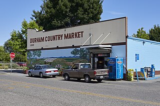
Durham is a census-designated place (CDP) in Butte County, California, United States. The population was 5,518 at the 2010 census.

<span class="mw-page-title-main">Rail Road Flat, California</span> Census-designated place in California, United States

Rail Road Flat is a census-designated place (CDP) in Calaveras County, California, United States. The population was 475 at the 2010 census, down from 549 at the 2000 census.

<span class="mw-page-title-main">Bucks Lake, California</span> Census-designated place in California, United States

Bucks Lake is a census-designated place (CDP) in Plumas County, California, United States. Bucks Lake is located on the south shore of the lake of the same name, 13 miles (20.9 km) west-southwest of Quincy. The population was 22 at the 2020 census, up from 10 at the 2010 census.

<span class="mw-page-title-main">Clio, California</span> Census-designated place in California, United States

Clio is a census-designated place in Plumas County, California, United States. Clio is located 23 miles (37.0 km) southeast of Quincy. The population was 66 at the 2010 census, down from 90 at the 2000 census.

<span class="mw-page-title-main">Georgetown, Connecticut</span> Census-designated place in Connecticut, United States

Georgetown is a census-designated place in Fairfield County, Connecticut, United States. It is located in the area where the towns of Wilton, Redding, Weston, and Ridgefield meet.

<span class="mw-page-title-main">Kensington, Connecticut</span> Census-designated place in Connecticut, United States

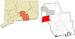
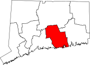
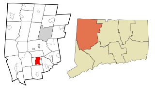
Kensington is a census-designated place (CDP) and section of the town of Berlin in Hartford County, Connecticut, United States. The Berlin town offices are located in Kensington. The population was 8,459 at the 2010 census.

<span class="mw-page-title-main">Terramuggus, Connecticut</span> Census-designated place in Connecticut, United States

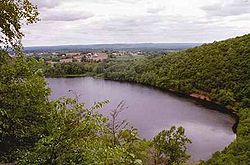
Terramuggus is a census-designated place (CDP) in the town of Marlborough, Hartford County, Connecticut, United States. It contains the town center village and surrounding areas. The population was 1,025 at the 2010 census.

<span class="mw-page-title-main">Woodbury, Connecticut</span> Town in Connecticut, United States

Woodbury is a town in Litchfield County, Connecticut, United States. The town is part of the Naugatuck Valley Planning Region. The population was 9,723 at the 2020 census. The town center, comprising the adjacent villages of Woodbury and North Woodbury, is designated by the U.S. Census Bureau as the Woodbury Center census-designated place (CDP). Woodbury was founded in 1673.

<span class="mw-page-title-main">Chester, Connecticut</span> Town in Connecticut, United States

Chester is a town in Middlesex County, Connecticut, United States. The town is part of the Lower Connecticut River Valley Planning Region. The population was 3,749 at the 2020 census. The town center is defined by the U.S. Census Bureau as a census-designated place (CDP). The name is a transfer from Chester, in England.

<span class="mw-page-title-main">Deep River, Connecticut</span> Town in Connecticut, United States

Deep River is a town in Middlesex County, Connecticut. The town is part of the Lower Connecticut River Valley Planning Region. The population was 4,415 at the 2020 census. The town center is designated by the U.S. Census Bureau as a census-designated place (CDP). Deep River is part of what the locals call the "Tri-town Area", made up of the towns of Deep River, Chester, and Essex.

<span class="mw-page-title-main">Higganum, Connecticut</span> Census-designated place in Connecticut, United States

Higganum is a village and census-designated place (CDP) in the town of Haddam, a part of Middlesex County, Connecticut, United States. The population was 2,089 at the 2020 census.

<span class="mw-page-title-main">Westbrook, Connecticut</span> Town in Connecticut, United States

Westbrook is a town in Middlesex County, Connecticut, United States. The town is part of the Lower Connecticut River Valley Planning Region. The population was 6,769 at the 2020 census. The town center is classified by the U.S. Census Bureau as a census-designated place (CDP).

<span class="mw-page-title-main">Long Hill, Groton, Connecticut</span> Census-designated place in Connecticut, United States

Long Hill is a census-designated place (CDP) in the town of Groton in New London County, Connecticut, United States. The population was 4,205 at the 2010 census.

<span class="mw-page-title-main">Somers, Connecticut</span> Town in Connecticut, United States

Somers is a town in Tolland County, Connecticut. The town is part of the Capitol Planning Region. The population was 10,255 at the 2020 census. The town center is listed by the U.S. Census Bureau as a census-designated place (CDP). In 2007, Money Magazine listed Somers 53rd on its "100 Best Places to Live", based on "economic opportunity, good schools, safe streets, things to do and a real sense of community."

<span class="mw-page-title-main">East Brooklyn, Connecticut</span> Census-designated place in Connecticut, United States

East Brooklyn is a census-designated place (CDP) located within the town of Brooklyn in Windham County, Connecticut. It is the portion of the Danielson urban cluster within the town of Brooklyn. The population was 2,205 at the 2020 census. US 6 runs through the town and severs the town.

<span class="mw-page-title-main">Putnam (CDP), Connecticut</span> Census-designated place in Connecticut, United States

Putnam District is a village and census-designated place (CDP) in Windham County, Connecticut, United States. The CDP was formed when the former city of Putnam disincorporated, and it consists of the main town center of the town of Putnam along the Quinebaug River. The village is part of the Northeastern Connecticut Planning Region. The population was 7,214 at the 2010 census.

<span class="mw-page-title-main">Bethlehem Village, Connecticut</span> Census-designated place in Connecticut, United States

Bethlehem Village is a census-designated place (CDP) within the town of Bethlehem in Litchfield County, Connecticut, United States. The CDP includes the Bethlehem Green Historic District at the town center, as well as surrounding residential and rural land. As of the 2010 census, the CDP had a population of 2,021, out of a population of 3,607 for the entire town of Bethlehem.

<span class="mw-page-title-main">Glastonbury Center, Connecticut</span> Census-designated place in Connecticut, United States

Glastonbury Center is a census-designated place (CDP) that constitutes the densely populated center of the town of Glastonbury in Hartford County, Connecticut, United States. The population was 7,387 at the 2010 census, out of a total town population of 34,427.

<span class="mw-page-title-main">Clinton, Connecticut</span> Town in Connecticut, United States

Clinton is a town in Middlesex County, Connecticut, United States. The town is part of the Lower Connecticut River Valley Planning Region. The population of the town was 13,185 at the 2020 census. The town center along the shore line was listed as a census-designated place (CDP) by the U.S. Census Bureau in the 2020 census.

<span class="mw-page-title-main">Greenwich (CDP), Connecticut</span> Census-designated place in Connecticut, United States

Greenwich is a census-designated place (CDP) in Fairfield County, Connecticut, United States. It is one of several CDPs within the town of Greenwich and corresponds to the historic municipal center of the town and surrounding residential and commercial areas. As of the 2010 census, the population of the Greenwich CDP was 12,942, out of 61,171 in the entire town.

References

  1. 1 2 U.S. Geological Survey Geographic Names Information System: Durham, Connecticut
  2. "Census - Geography Profile: Durham town, Middlesex County, Connecticut" . Retrieved November 28, 2021.
  3. The Connecticut Magazine: An Illustrated Monthly. Connecticut Magazine Company. 1903. p. 332.
  4. Gannett, Henry (1905). The Origin of Certain Place Names in the United States. Govt. Print. Off. pp.  111.
  5. 1 2 Cohen, Patricia C. (1999). The Murder of Helen Jewett. Vintage. ISBN   0-679-74075-9. p. 235
  6. "Census of Population and Housing". Census.gov. Retrieved June 4, 2015.
  7. 1 2 "U.S. Census website". United States Census Bureau . Retrieved January 31, 2008.
  8. "Election 2007 Returns" (PDF). Town of Durham, Connecticut. Retrieved April 4, 2020.
  9. "Registration and Party Enrollment Statistics as of October 25, 2011 publisher = Connecticut Secretary of State" (PDF). Retrieved February 24, 2012.{{cite web}}: Missing pipe in: |title= (help)
  10. "Official Results State Election and Referendum November 6, 2018" (PDF). Town of Durham, Connecticut. Retrieved April 4, 2020.
  11. "General Elections Statement of Vote 1922".
  12. "General Election Statements of Vote, 1922 – Current". CT Secretary of State. Retrieved December 24, 2020.
  13. "Election Night Reporting". CT Secretary of State. Archived from the original on April 28, 2016. Retrieved December 24, 2020.
  14. "Elias Austin House (1743)". January 29, 2010.
  15. Who Was Who in America, Historical Volume, 1607-1896. Chicago: Marquis Who's Who. 1963.