The Bolton Center Historic District is the historic center of the town of Bolton, Massachusetts. The district encompasses what is essentially a linear town center, strung out principally along Main Street, with a well-preserved collection of residential and civic architecture spanning more than two centuries. The district was listed on the National Register of Historic Places in 1996.

The Worthington Ridge Historic District encompasses the historic town center of Berlin, Connecticut. It runs mostly along Worthington Ridge Road from the intersection of Mill Street to Sunset Lane. This section of road was historically part of the Boston Post Road laid out in 1673, and is now lined by a diversity of residential architecture and several of the town's civic buildings. In 1974, the Berlin Historic District was formed in order to preserve the integrity of the architecture of the village. The district was listed on the National Register of Historic Places in 1989.

The Branford Point Historic District is a historic district in Branford, Connecticut. It was listed on the National Register of Historic Places in 1988. It includes a significant portion of the Branford Point neighborhood, generally considered to be the area along the west side of the Branford Harbor to the Amtrak railroad tracks. It is bounded on the west by the Short Beach neighborhood, on the north by Branford Center, and on the east by the Branford River. Harbor Street, Maple Avenue, and Stannard Avenue are the main thoroughfares of the neighborhood. In the 2000 Census, Branford Point was included by the U.S. Census Bureau in the Branford Center census-designated place.

The Simsbury Center Historic District is a 75-acre (30 ha) historic district located in the town center area of Simsbury, Connecticut. It encompasses seven blocks of Hopmeadow Street, as well as the cluster of commercial, civic, and residential buildings along Railroad, Station, and Wilcox Streets, and Phelps Lane. Although its oldest element is the cemetery, most of its buildings were built in the late 19th and early 20th century. It was listed on the National Register of Historic Places in 1996.

The Agawam Center Historic District is a historic district that encompasses part of the historic center of Agawam, Massachusetts. The district covers most of the buildings along Elm Street and Main Street radiating out from their intersection in both directions. The district is predominantly residential, although it does contain many commercial, industrial, and civic buildings. Many of the buildings in the district stand at a uniform setback from the street, giving the district a coherent feel.

The Granville Village Historic District is a historic district encompassing the historic Granville Village area in eastern Granville, Massachusetts. The area was developed in the 19th century as an industrial village, centered on the drum factory of Noble & Cooley on Dickinson Brook. The predominantly residential district includes a number of Greek Revival houses; it also includes the Colonial Revival public library building. It is located roughly in the area around the junction of Maple St. and Main and Granby Rds., including part of Water Street. The district was listed on the National Register of Historic Places in 1991.

The Torringford Street Historic District is a historic district on the east side of the city of Torrington, Connecticut. The district includes properties along Torringford Street, the main thoroughfare of the Torringford section of the city, between United States Route 202 and West Hill Road. The road is one of the oldest in Torrington, and this section is notable for containing a cross-section of well-preserved architecture from the 18th to the mid-20th centuries. The district was listed on the National Register of Historic Places in 1991.

The Greenwich Avenue Historic District is a historic district representing the commercial and civic historical development of the downtown area of the town of Greenwich, Connecticut. The district was listed on the National Register of Historic Places on August 31, 1989. Included in the district is the Greenwich Municipal Center Historic District, which was listed on the National Register the year before for the classical revival style municipal buildings in the core of Downtown. Most of the commercial buildings in the district fall into three broad styles, reflecting the period in which they were built: Italianate, Georgian Revival, and Commercial style. The district is linear and runs north–south along the entire length of Greenwich Avenue, the main thoroughfare of Downtown Greenwich, between U.S. Route 1 and the New Haven Line railroad tracks.

The Granby Center Historic District is a predominantly residential historic district encompassing a portion of the village of Granby Center in Granby, Connecticut. The village developed in the 18th century as a farming center, and a now includes a variety of architectural styles from the late 18th to early 20th centuries. The district was listed on the National Register of Historic Places (NRHP) in 1985.

The Canton Center Historic District encompasses the historic rural town center of Canton, Connecticut. Extending mainly along Connecticut Route 179, near the geographic town center, is a well-preserved example of a rural agricultural center in Connecticut, a role served until about 1920. The district includes many examples of Late Victorian and Greek Revival architecture. It was listed on the National Register of Historic Places in 1997.

The Old Saybrook South Green is a 20-acre (8.1 ha) historic district that encompasses the historic town green and nearby streets in Old Saybrook, Connecticut. Established in the 1630s, most of the buildings arrayed around the green were built between 1760 and 1900, and reflect the prosperity of the town, which was a major port and shipbuilding center. The district was listed on the National Register of Historic Places in 1976.

The Glastonbury Historic District encompasses a streetscape dating to the 17th century, along Main St. from Hebron Ave. to Talcott Rd. in Glastonbury, Connecticut. In addition to a significant number of 17th and 18th-century houses, it shows the architectural development of the town over time, with buildings spanning three centuries in construction dates. It was listed on the National Register of Historic Places in 1984.

The Suffield Historic District is a historic district encompassing the Main Street area of the town center of Suffield, Connecticut, USA. It was listed on the National Register of Historic Places in 1979 and is part of a larger local historic district. It runs along North and South Main Street from Muddy Brook to north of Mapleton Avenue, and includes a diversity of 18th through early 20th-century architecture.

The Town Center Historic District encompasses the historic village center of South Hampton, New Hampshire. Centered around the Barnard Green, the town common, on New Hampshire Route 107A, it includes architectural reminders of the town's growth and change over time. The district was listed on the National Register of Historic Places in 1983.

The Plymouth Center Historic District encompasses historic early village center of Plymouth, Connecticut. Stretching along Main, North and South Streets from their junction, it flourished in the 19th century with small-scale industries, but declined late in the century with the separation of Thomaston and the more significant industrial development at Terryville. The district features colonial, Federal, and Greek Revival architecture and was added to the National Register of Historic Places in 1999, with a slight enlargement the following year.

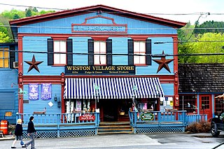
The Weston Village Historic District encompasses the town center and principal village of Weston, Vermont. Centered on Farrar Park, which serves as the town green, it includes a diversity of architectural styles from the late 18th century to about 1935, and includes residential, civic, commercial, industrial and religious buildings. It was listed on the National Register of Historic Places in 1985.

The Enfield Historic District encompasses a two-mile stretch of Enfield Street, the main north-south road of Enfield, Connecticut. Centered on the town common with its church and old town hall, it includes a diversity of residential architecture from the 18th to early 20th centuries. The district was listed on the National Register of Historic Places in 1979.

The Rocky Hill Center Historic District encompasses the traditional town center and surrounding residential area of Rocky Hill, Connecticut. It extends along Old Main Street from the Wethersfield line southward to a triangular area bounded by Old Main, Riverview Road, and Glastonbury Avenue. Included in a basically 19th-century streetscape are the town's principal civic and religious buildings, as well as a fine collection of mainly 18th and 19th-century residential architecture. The district was listed on the National Register of Historic Places in 2007.

The Westbrook Town Center Historic District encompasses the historic town center of Westbrook, Connecticut. Roughly linear in shape, the district extends along the Boston Post Road, with its focal center at the junction with Essex Road. The area has been a center of civic activity since the early 18th century, even though Westbrook was not incorporated until 1840, and has residential, commercial, civic, and religious architecture covering three centuries. The district was listed on the National Register of Historic Places in 2017.

The Middlebury Center Historic District encompasses the historic civic and religious center of Middlebury, Connecticut. Centered at the junction of North and South Streets with Whittemore Road, the district includes churches, schools and municipal buildings, many from the late 19th or early 20th centuries, as well as a diversity of residential architecture. The district includes all the residences along the entire length of North Street, which leads up to the town green. The district was listed on the National Register of Historic Places in 1985.


