By 1614, the Dutch had surveyed, charted, and established New Netherland, a colonial province, with claimed territories from the Delmarva Peninsula to Cape Cod. This included claims over the Quinnipiac territory. However, a lack of any significant Dutch presence in the area gave English settlers an opportunity to settle in the Quinnipiac territory.[6] Dutch claims over land that included Menunkatuck (and would later include Guilford) remained until the 1674 Treaty of Westminster that ended the Third Anglo-Dutch War.
In June 1637 during the Pequot War, a force of 100 English soldiers and Narragansett, Mohegan, and Montauk allies arrived from Long Island in pursuit of the Pequot grand sachemSassacus near Menunkatuck. At a neck of land known today as Sachems Head, they captured and executed three Pequot sachems before continuing on west in pursuit of Sassacus.[7]
In 1639, after landing in the plantation of Quinnipiaic (later known as New Haven) via ship from England, a group of 24 English Puritan families led by Rev. Henry Whitfield chose to settle almost 13 miles away near Menukatuck.[5] During their voyage from England, the settlers drafted and signed the Plantation Covenant on June 1, 1639 (O.S.). The text of the covenant is memorialized by an engraved pink Stony Creek granite slab at the corner of Old Whitfield and Whitfield streets.[8] On September 29, 1639 (O.S.), the colonists secured a land grant for their settlement from Shaumpishuh, the female sachem of Menunkatuck.[9]
1838 view of Guilford from the Green showing (left to right) the Academy, the Congregational Church, and the Town House
The English settlement originally shared the name Menunkatuck with the Quinnipiac village. On July 6, 1643 (O.S.), records of the General Court session held at New Haven note that Menunkatuck changed its name to “Guilforde,” although no reason for the change was recorded.[11] It is assumed that Guilford was named after the town of Guildford, England,[12] the native home of a share of its first English settlers.[13] In early maps of the Connecticut Colony, the town is seen on several maps as "Gilford."
1881 bird's eye view of Guilford
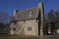
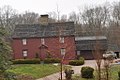
Guilford is considered by some to have the third largest collection of historic homes in New England, with important buildings from the 17th, 18th, and 19th centuries.[14] There are five historic house museums, including Dudley Farm and the Henry Whitfield House (1639), the oldest dwelling house in Connecticut and the oldest stone house built by English settlers in North America. The Comfort Starr House (1695) is one of the oldest wooden framed private dwellings in Connecticut, and one of the few houses remaining of the original signers who settled Guilford.[15]
In June 1781, during the American Revolution, a skirmish was fought on Leete's Island between the Associated Loyalists and local militia under Captain Peter Vail.
Guilford, c.1900
Geography
According to the United States Census Bureau, the town has a total area of 49.7 square miles (129km2), of which 47.0 square miles (122km2) is land and 2.7square miles (6.9km2 or 5.39%) is water.
The primary settlement in Guilford, known as Guilford Center, is located in the southern part of town around the intersection of U.S. Route 1 and Connecticut Route 77. It is served by three exits of Interstate 95, which passes just north of the town center. The Guilford Center census-designated place had a population of 2,597 at the 2010 census.[16]
The northwest side of Guilford is flanked by the Metacomet Ridge, a mountainous trap rock ridgeline that stretches from Long Island Sound to nearly the Vermont border. Important features of the Metacomet ridge in Guilford include Totoket Mountain; its most notable peak, Bluff Head; and two eastern high points on the Totoket Mountain ridge named East Sugarloaf and West Sugarloaf. The 50-mile (80km)Mattabesett Trail traverses Bluff Head; a shorter network of trails criss-cross the Sugarloaves. Guilford also contains the Westwoods Trail System which covers 39 miles (63km) of trails on 1,200 acres (4.9km2) of land.
US1, known locally as Boston Post Road, also runs through downtown Guilford, serving as the town's main commercial area. It connects to I-95, Route 77, and Route 146. It follows a similar route to I-95, connecting to Boston to the North and New York City to the South.
Route77 is the main route between downtown Guilford and the neighboring town of Durham. It begins at the town green at a junction with Route 146. From there it heads North through the town crossing US 1, I-95, and Route 80. From there it passes through North Guilford and into Durham, ending just South of the Durham town center at a junction with Route 17.
Route146 is a scenic coastal road connecting downtown Guilford to the neighboring town of Branford. It begins on the East side of town at a junction with Route 1. From there it passes along the South side of the town green where it connects to the Southern terminus of Route 77. It continues along the coast, through the neighborhood of Sachem's Head and into Branford.
As of the census[19] of 2000, there were 21,398 people, 8,151 households, and 6,039 families residing in the town. The population density was 454.8 inhabitants per square mile (175.6/km2). There were 8,724 housing units at an average density of 185.4 per square mile (71.6/km2). The racial makeup of the town was 96.04% White, 0.93% African American, 0.05% Native American, 1.65% Asian, 0.41% from other races, and 0.93% from two or more races. Hispanic or Latino of any race were 2.13% of the population.
There were 8,151 households, out of which 35.6% had children under the age of 18 living with them, 64.4% were married couples living together, 7.2% had a female householder with no husband present, and 25.9% were non-families. Of all households 21.6% were made up of individuals, and 8.6% had someone living alone who was 65 years of age or older. The average household size was 2.59 and the average family size was 3.04.
In the town, the population was spread out, with 25.4% under the age of 18, 4.4% from 18 to 24, 26.2% from 25 to 44, 31.2% from 45 to 64, and 12.8% who were 65 years of age or older. The median age was 42 years. For every 100 females, there were 92.8 males. For every 100 females age 18 and over, there were 89.5 males.
The median income for a household in the town was $76,843, and the median income for a family was $87,045 (these figures had risen to $90,026 and $104,852 respectively as of a 2007 estimate[20]). Males had a median income of $60,623 versus $40,307 for females. The per capita income for the town was $37,161. About 2.3% of families and 3.1% of the population were below the poverty line, including 3.4% of those under age 18 and 3.8% of those age 65 or over.
Government
Voter registration and party enrollment as of October 31, 2024[21]
Guilford is served by the Guilford Public Schools district, which provides comprehensive education from kindergarten through high school. The district comprises four elementary schools, two middle schools, and a high school, offering a range of academic and extracurricular programs.
Elementary schools: Guilford has four elementary schools: Calvin Leete Elementary School,[28] A.W. Cox Elementary School,[29] Melissa Jones Elementary School,[30] and Guilford Lakes Elementary School.[31]
Middle schools: Baldwin Middle School serves students in grades five through six.[32] Adams Middle School serves students in grades seven through eight.[33]
High school: Guilford High School, serving grades nine through twelve, offers a wide array of academic courses, including Advanced Placement (AP) classes and college preparatory programs.[34]
Public library
The Guilford Free Library is a resource for the community, providing access to a vast collection of books, digital media, historical materials about Guilford's history and genealogy, and educational programs for all ages.[35] The library hosts numerous events, workshops, and activities aimed at promoting literacy and lifelong learning.
Parks and recreation areas
Town
The following parks are owned and operated by the town government:[36]
Bittner Park: 136 acres including a playground, a lighted softball field (Cash Mitchell Field), baseball and soccer fields, basketball and pickleball courts, hiking/horseback riding/cross country skiing trails, a skate park, public bathrooms, and a disc golf course
Braemore Preserve: 95 acres with 8 miles of hiking trails, including a section of the Lone Pine Trail which connects it to Bluff Head and Northwoods and the James Valley Preserve
Chaffinch Island Park: 22 acre park at the mouth of the West River with picnic tables, grills, and fishing access
Chittenden Park: Softball and soccer fields, bocce courts, picnicking, and a boardwalk to Long Island Sound. This park is the southern terminus of the New England National Scenic Trail
Daniel Avenue Beach: 3/4 acre unsupervised beach providing access to Indian Cove on Long Island Sound. Shellfishing is allowed by permit
East River Preserve: 583 acres with 7.6 miles of hiking trails along the East River
Grass Island: 30 acre park including the Grass Island Shack (a local landmark). There are no formal trails. It is accessible by road from Madison or by crossing the East River by boat from the Town Marina.
Guilford Marina: Small boat marina. Boat ramp and fishing access
Jacobs Beach: 25 acre park on Long Island Sound, with a supervised beach, playground, splash pad, picnic area, pavilions, kayak racks, volleyball courts, half basketball court, and bathhouse
James Valley Preserve: 75 acres with hiking trails (including a section of the Lone Pine Trail) that adjoins the Bluff Head and Northwoods property maintained by the land trust
Lake Quonnipaug: Allowing access to the largest lake in Guilford, this property includes a 41-acre park with bathrooms, picnic tables, a pavilion, and a supervised beach. The lake is open for swimming, paddling, and fishing.
Long Hill Park: 10 acre park with playing fields for baseball, football, soccer/lacrosse and field hockey
Mill Pond: 1 acre park with picnic area and fishing access. Ice skating in the winter
Nut Plains Park: 23 acres including a dog park, lacrosse fields, and a short trail
Shell Beach: 1 acre unsupervised beach providing access to Long Island Sound. Shellfishing is allowed by permit
Timberlands Preserve: 600 acres with 15 miles of trails featuring the Iron Stream, Upper Guilford Lake, and a section of the New England Trail
Trolley Road: Small unsupervised beach, providing access to Long Island Sound. Shellfishing is available by permit
Town Green: 7.7 acres in the town's historic district, surrounded by shops, churches, the town hall, and the Nathanael B. Greene Community Center (which has meeting rooms and event spaces)
Land Trust
The Guilford Land Conservation Trust (GLCT) manages the following properties for public use:[39]
Big Maple: 31 acres, 1.1 miles of trails, Chestnut Creek, and what may be one of the largest sugar maples in Connecticut
Bluff Head and Northwoods: 870 acres with 14 miles of hiking trails, including a section of the New England Trail, a section of the Lone Pine Trail, Hemlock Brook, Myerhuber Pond, the Broomstick Ledges, and Bluff Head (the highest point of Totoket Mountain). This property adjoins James Valley Preserve, which is owned and managed by the Town of Guilford
County Road Fields: 25 acres, no formal trails
Dudley Barrows Woods: 120 acres with hiking trails and scenic vistas
East River Woodlands: 106 acres with hiking trails near the East River
Eastwoods: 95 acres with hiking trails (including a section of the New England Trail), adjoining East River Preserve (owned and managed by the Town of Guilford) as well as another GLCT property (Nut Plains Woods)
Jared Eliot Preserve: 36 acres of farmland once owned by Jared Eliot, now features a short hiking trail along the West River
Kampmeyer Preserve: 100 acres with hiking trails featuring Notch Hill Brook and the surrounding wetlands
Meeting House Hill Preserve: 25 acres located across from the Meeting House Hill Historic District. This property is maintained for pollinators and field nesting birds and has no formal trails
Munger Brook Preserve: 21 acres featuring a short hiking trail and the headwaters of Munger Brook
Neck River North: A small preserve with a trail that provides access to Cockaponset State Forest in Madison as well as land owned by the Madison Land Trust
Nut Plains Woods: 57 acres with hiking trails (including a section of the New England Trail), adjoining East River Preserve (owned and managed by the Town of Guilford) as well as another GLCT property (Eastwoods)
Olmsted Outlook: A half acre park on the banks of the West River, close to the town center. It includes a historic sea wall, a lawn, flower beds, and a view of the West River and the surrounding Marshlands (which are also protected by the GLCT). The property is named for architect Frederick Law Olmsted, who visited Guilford in the 1830s, and may have taken some inspiration from the view over the West River when designing his later projects.
Priscilla Otte Preserve: 32 acres with hiking trails, a stream, a cave, and a historic barn
Spencer Creek Preserve: 11.5 acres with hiking trails and views of Spencer Creek and the West River
Tanner Marsh Brook: 5 acres along the banks of the Tanner Marsh Brook, following its course from Tanner Marsh Road to the East River
Westwoods: The largest trail system in Guilford with over 32 miles of hiking trails featuring caves, waterfalls, marshes, and Lost Lake. The property is connected to parts of Cockaponset State Forest
State forest
There are two parcels of Cockaponset State Forest in Guilford. One, just north of Route 80 contains a section of the New England Trail and connects to the town owned Timberlands Preserve to the south of Route 80. The other parcel adjoins several Land Trust properties, collectively making up Westwoods.[40]
Other
There are three outdoor recreation areas in Guilford that are owned by other organizations and are open to the public:
Genesee Recreation Area: Owned by the South Central Connecticut Regional Water Authority, this area is accessible by permit and contains around 12 miles of trails, including a section of the New England Trail. It also contains several foundations and stone walls that are the remnants of the Little Genesee Settlement, active between 1770 and 1875[41]
Guilford, Connecticut is noted for its rolling farmland, its avoidance of the density and sprawl that has occurred from land use regulations of its neighboring communities, and its numerous historic homes and sites.[44]
Museum includes the saltboxhouse, a historic blacksmith shop, a barn with farm tools and implements, two corn cribs and aVictorian erathree seatouthouse.
Humbert Allen Astredo (1929–2016), American stage, film, and television actor best known for the numerous roles he performed on the daytime Gothic horror soap opera Dark Shadows, most notably that of the warlock Nicholas Blair
Samuel Johnson (1696–1772), American colonial intellectual and educator; first president of King's College (now Columbia University)
Samuel Johnson Jun'r (1757–1836), schoolmaster and teacher of Fitz-Greene Halleck; as the compiler of A School Dictionary (1798), the first American lexicographer
Nick Benas (b. 1979) – United States Marine Corps veteran, author, martial arts instructor; author of bestselling books on resilience, stoicism and leadership. Raised in Guilford, Connecticut.[53]
↑"General Information"Archived January 21, 2012, at the Wayback Machine . American Cruise Lines. Retrieved on January 15, 2012. "American Cruise Lines, Inc. operates from headquarters in Guilford, Connecticut[...]"
↑"Cruise News". (Archive) American Cruise Lines. Retrieved on January 15, 2012. "741 Boston Post Road ٠ Suite 200 ٠ Guilford, CT"
This page is based on this Wikipedia article Text is available under the CC BY-SA 4.0 license; additional terms may apply. Images, videos and audio are available under their respective licenses.