
Guilford is a town in New Haven County, Connecticut, United States, that borders Madison, Branford, North Branford and Durham, and is situated on I-95 and the Connecticut coast. The town is part of the South Central Connecticut Planning Region. The population was 22,073 at the 2020 census.

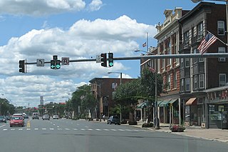
Branford Center is a neighborhood and census-designated place (CDP) in the town of Branford, Connecticut, United States. The CDP encompasses the traditional town center area and the area known as Branford Point. The population of the CDP was 5,819 at the 2010 census.

Wilder is an unincorporated village and census-designated place (CDP) within the town of Hartford in Windsor County, Vermont, United States. It is the location of the Wilder Dam on the Connecticut River. The population of the CDP was 1,690 at the 2010 census. The village center is an early example of a planned mill community, and was listed on the National Register of Historic Places as the Wilder Village Historic District in 1999.
Falls Village is a village and census-designated place in the town of Canaan in Litchfield County, Connecticut, United States. As of the 2010 census it had a population of 538, out of 1,234 in the entire town of Canaan. Because Falls Village is the town center and principal constituent village in Canaan, the entire town is often referred to as "Falls Village". That usage also avoids confusion of the town with Canaan Village in the town of North Canaan, Connecticut, just to the north. Falls Village derives its name from a waterfall, known as Great Falls, on the Housatonic River within the village.
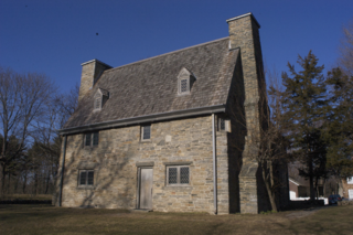
The Henry Whitfield House is a historic house located in Guilford, Connecticut, down the street from the town green. This house dates from 1639, having been built just before the town of Guilford was settled. It is the oldest house in Connecticut and the oldest stone house in New England. It also served as a fort to protect the community with its massive stone walls. Henry Whitfield was a Puritan minister who had come from England to flee religious persecution, and the settlers built the house for him. The house was remodeled in 1868 and opened to the public in 1899 as the Henry Whitfield State Museum, the first Connecticut state museum. It was restored in 1902–04 and again in the 1930s, and it was declared a National Historic Landmark in 1997. It was named a State Archeological Preserve in 2006.

Quinebaug Mill–Quebec Square Historic District is a historic district roughly bounded by the Quinebaug River, Quebec Square, and Elm and S. Main Streets in the town of Brooklyn in Windham County, Connecticut, United States. The district encompasses a well-preserved 19th-century mill village. It was added to the National Register of Historic Places in 1985.

The Hampton Hill Historic District encompasses the historic village center of Hampton, Connecticut, a small rural community in Windham County. It is a linear district, extending for about 1 mile (1.6 km) along Connecticut Route 97, the major north-south route through the town, and laid out as a tree-lined boulevard. Most of the district's 62 historic buildings were built in the 19th century, with fifteen houses surviving from the 18th. Architecturally, they represent a cross-section of styles popular from the mid-18th to early 20th centuries, with vernacular forms most commonly found. One of the oldest buildings is a c. 1727 tavern, since converted to a private residence, while the town hall is located in an undistinguished 1920s former firehouse.

The Hadley Center Historic District is an expansive, 2,500-acre (1,000 ha) historic district encompassing the village center of Hadley, Massachusetts. When it was first listed on the National Register of Historic Places in 1977, the district encompassed the town green and 17 buildings that faced it, at the junction of Russell Street and Middle Street. The district was expanded significantly in 1994, adding more than 400 buildings representative of the village's growth from colonial days into the first decades of the 20th century. This expansion encompasses the entirety of a tongue of land extending west from East Street and bounded by a bend in the Connecticut River, which separates Hadley from Northampton. Its oldest property, the Samuel Porter House on West Street, was built in 1713.

The Hatfield Center Historic District encompasses the traditional center of Hatfield, Massachusetts. The area, first laid out in 1661, is bounded by Maple Street to the south, the Connecticut River to the east, Day Avenue and School Street to the north, and the Mill River to the west. The area's layout and land use patterns are relatively little altered since they were laid out, leaving a well-preserved early colonial village landscape. The district was added to the National Register of Historic Places in 1994.

The Longmeadow Historic District is a historic district encompassing the village green of Longmeadow, Massachusetts and properties in its immediate vicinity. The district acquired local protection in 1973 and was added to the National Register of Historic Places in 1982.

The Dudleytown Historic District, also known as Clapboard Hill is a historic district in Guilford, Connecticut. Extending along Clapboard Hill Road for 1.4 miles (2.3 km), it encompasses a landscape whose land usage encapsulates all of the major regional rural development trends from the 17th to the early 20th centuries. It is architecturally dominated by rural vernacular residences of the 18th and 19th centuries. It was listed on the National Register of Historic Places in 1991.

The Bean Hill Historic District is a historic district in Norwich, Connecticut that was listed on the National Register of Historic Places in 1982. It consists of a well-preserved collection of buildings focused on the Bean Hill Green, which capture the 19th-century period when Bean Hill was a local center for manufacturing and commercial activity. The district is located in the vicinity of West Town Street between I-395 and Connecticut Avenue, and also extends northeast along Huntington Avenue to include properties further beyond Bean Hill Plain. The district is about 22 acres (8.9 ha) in size, with 23 contributing buildings.
The Downtown Main Street Historic District encompasses a well-preserved historical section of downtown East Hartford, Connecticut, United States. It extends along Main Street from between Burnside Avenue and Governor Street, and along Chapman Street to Chapman Place. Developed between about 1890 and 1945, its architecture encapsulates the town's transition from a main agrarian community to a modern suburb. The district was listed on the National Register of Historic Places in 1996.
The Jericho Rural Historic District encompasses a rural agricultural landscape of northern Hartford, Vermont, extending slightly into neighboring Norwich. The area covers 774 acres (313 ha) of mainly agricultural and formerly agricultural lands, as well as associated woodlots, and includes nine historically significant farm complexes. It was listed on the National Register of Historic Places in 2001.

The Weston Village Historic District encompasses the town center and principal village of Weston, Vermont. Centered on Farrar Park, which serves as the town green, it includes a diversity of architectural styles from the late 18th century to about 1935, and includes residential, civic, commercial, industrial and religious buildings. It was listed on the National Register of Historic Places in 1985.

The Broad Street Green Historic District encompasses the historic late-19th century town center of Windsor, Connecticut. It is centered around the Broad Street Green, a public park extending on the east side of Broad Street between Union and Batchelder Streets, and includes a diversity of architecture spanning much of the town's long history. It was listed on the National Register of Historic Places in 1999.

The East Granby Historic District encompasses a predominantly rural and agricultural area of the town of East Granby, Connecticut. Extending northward from the town center and covering some two square miles, it includes one of the state's highest concentrations of surviving 18th and early 19th-century farmsteads, and a relatively little-altered landscape. The district was listed on the National Register of Historic Places in 1988.

The Palisado Avenue Historic District encompasses a predominantly residential streetscape in northeastern Windsor, Connecticut. Extending along Palisado Avenue between the Farmington River and Bissell Ferry Road, it is a basically 18th-century street view, populated mainly with houses from the 18th to the 20th centuries. The district was listed on the National Register of Historic Places in 1987.

The Meeting House Hill Historic District encompasses the historic religious center of North Guilford, Connecticut. Located on Ledge Hill Road, the district includes two churches, a cemetery, and Ledge Hill Road itself, which dates to the early 18th century. The arrangement is reflective of a spirit of religious tolerance that manifested in the early 19th century, allowing churches from two different congregations to heal long-standing divisions. The district was listed on the National Register of Historic Places in 1987.

The Route 146 Historic District encompasses a historic streetscape in Branford and Guilford, Connecticut. Extending along Connecticut Route 146 between Flat Rock Road in Branford and the West River bridge in Guilford, it includes two centuries of rural residential architecture, and a well-preserved pre-World War II street layout created as a "state assistance road" in the 1920s. The district was listed on the National Register of Historic Places in 1990.


