Madison, Connecticut

Last updated

Madison, Connecticut
Town of Madison
Madison, Connecticut.jpg
Waterfront in Madison
MadisonCtTownSeal.jpg
Madison CT lg.PNG
Madison, Connecticut
Coordinates: 41°16′45″N72°35′45″W / 41.27917°N 72.59583°W / 41.27917; -72.59583
CountryFlag of the United States.svg  United States
U.S. state Flag of Connecticut.svg  Connecticut
County New Haven
Region South Central CT
Incorporated1826
Government
  Type Selectman-town meeting
  First SelectmanPeggy Lyons (D)
  SelectmanBruce Wilson (R)
  SelectmanJennifer Gordon (R)
  SelectmanAl Goldberg (D)
  SelectmanScott Murphy (D)
Area
  Total36.8 sq mi (95.3 km2)
  Land36.2 sq mi (93.8 km2)
  Water0.6 sq mi (1.5 km2)
Elevation
223 ft (68 m)
Population
 (2020)
  Total17,691
  Density480/sq mi (190/km2)
Time zone UTC−5 (Eastern)
  Summer (DST) UTC−4 (Eastern)
ZIP code
06443
Area code(s) 203/475
FIPS code 09-44560
GNIS feature ID0213454
Website www.madisonct.org

Madison is a town in the southeastern corner of New Haven County, Connecticut, United States, occupying a central location on Connecticut's Long Island Sound shoreline. The town is part of the South Central Connecticut Planning Region. The population was 17,691 at the 2020 census. [1]

Contents

History

Madison was first settled in 1641. Throughout the 18th century, Madison was known as East Guilford until it was incorporated as a town in 1826. The present name is after James Madison, 4th President of the United States. [2]

From 1935 to 1942, Madison served as the site of Camp Hadley, one of 23 Civilian Conservation Corps (CCC) camps in Connecticut. [3]

Geography

According to the United States Census Bureau, the town has a total area of 36.8 square miles (95.3 km2), of which 36.2 square miles (93.8 km2) is land and 0.6 square miles (1.5 km2), or 1.6%, is water. Madison is bordered by the municipalities of Clinton and Killingworth to the east, Durham to the north, Guilford to the west, and Long Island Sound to the south.

Principal communities

Demographics

Historical population
CensusPop.Note
1850 1,837
1860 1,8651.5%
1870 1,814−2.7%
1880 1,672−7.8%
1890 1,429−14.5%
1900 1,5186.2%
1910 1,5341.1%
1920 1,85721.1%
1930 1,9183.3%
1940 2,24517.0%
1950 3,07837.1%
1960 4,56748.4%
1970 9,768113.9%
1980 14,03143.6%
1990 15,48510.4%
2000 17,85815.3%
2010 18,2692.3%
2020 17,691−3.2%
U.S. Decennial Census [5]

As of the 2000 census, [6] there were 17,858 people, 6,515 households, and 5,120 families residing in the town. The population density was 493.3 inhabitants per square mile (190.5/km2). There were 7,386 housing units at an average density of 204.0 per square mile (78.8/km2). The racial makeup of the town was 96.62% White, 0.40% African American, 0.06% Native American, 1.71% Asian, 0.01% Pacific Islander, 0.25% from other races, and 0.94% from two or more races. Hispanic or Latino of any race were 1.34% of the population.

There were 6,515 households, out of which 39.1% had children under the age of 18 living with them, 69.8% were married couples living together, 6.6% had a female householder with no husband present, and 21.4% were non-families. 18.5% of all households were made up of individuals, and 8.5% had someone living alone who was 65 years of age or older. The average household size was 2.72 and the average family size was 3.12.

The town's population was distributed with 28.2% under the age of 18, 3.8% from 18 to 24, 25.3% from 25 to 44, 28.6% from 45 to 64, and 14.1% who were 65 years of age or older. The median age was 41 years. For every 100 females, there were 93.2 males. For every 100 females age 18 and over, there were 89.8 males.

The median income for a household in the town was $87,437, and the median income for a family was $101,297. Males had a median income of $73,525 versus $41,058 for females. The per capita income for the town was $40,537. About 0.9% of families and 1.3% of the population were below the poverty line, including 0.5% of those under age 18 and 2.4% of those age 65 or over.

Arts and culture

Library

The E.C. Scranton Memorial Library was built in 1901, and was designed by architect Henry Bacon. The library was expanded in 1989.[ citation needed ]

National Register of Historic Places listings

E.C. Scranton Memorial Library, c. 1906 PostcardMadisonCTScrantonLibr1906.jpg
E.C. Scranton Memorial Library, c.1906
Deacon John Grave House Deacon John Graves House Madison.jpg
Deacon John Grave House

Parks and recreation

Beaches

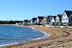
Hammonasset Beach State Park contains the state's longest public beach, with campsites, picnic areas, and a fishing pier. Beaches included Surf Club Beach, East Wharf, and West Wharf. The Madison Beach Club is located there.[ citation needed ]

Government

Voter registration and party enrollment as of October 27, 2020 [7]
PartyActive votersInactive votersTotal votersPercentage
Republican 4,1381504,28829.97%
Democratic 3,5361343,67025.65%
Unaffiliated 5,5702405,81040.61%
Minor parties841850.59%
Total13,69661014,306100%

Madison was once overwhelmingly Republican in federal elections. In 1924, a strong year for the GOP, town voters gave 85.83% to Republican Calvin Coolidge. [8] The town voted against Franklin Delano Roosevelt in each of his successful campaigns. [9] [10] [11] [12]

Even in 1964, a strong Democratic year, the town gave Barry Goldwater 1,605 votes against Lyndon Johnson with 1,470 votes. [13]

However, Madison residents have delivered Democratic wins in recent years. In the 2008 presidential election, Democrat Barack Obama received 55.78% of the vote in Madison, winning against Republican John McCain with 43.25%. [14] This was the first time that the town had ever voted for a Democrat for president. In 2016, voters gave Democrat Hillary Clinton 54.5% of the vote, while Republican opponent Donald Trump won 41.3% [15] In 2020, voters gave Democrat Joe Biden 53% of the vote, while Republican Donald Trump received only 37.3%. [16]

Education

Madison Public Schools serve grades K–12 and include Ryerson Elementary School, Jeffery Elementary School, Brown Middle School, Polson Middle School, and Daniel Hand High School.

Private elementary schools in Madison include Our Lady of Mercy Preparatory Academy, The Country School, and Grove School.

Infrastructure

Transportation

Madison train station is served by Shore Line East Madison station panorama.jpg
Madison train station is served by Shore Line East

Major roads in Madison include I-95, US 1, and state highway Routes 79 and 80.

Madison train station is served by the Shore Line East commuter railroad, with service to New Haven's Union Station to the west and the Old Saybrook train station to the east, facilitating connections to the MTA's Metro-North Railroad and to Amtrak's Northeast Regional and Acela Express services.

9 Town Transit routes 641 and 645 provide public bus service between Madison Center and Old Saybrook and Middletown, respectively, along U.S. Route 1. From June 20, 2021, to September 6, 2021, 9 Town Transit also operated the Madison Shuttle, providing service between Madison Park and Ride and Hammonasset Beach. CT Transit's route 201 bus connects Madison Center to New Haven.

From 1931 to 2007, Madison was served by Griswold Airport.

Notable people

Sister cities

Related Research Articles

<span class="mw-page-title-main">New Haven County, Connecticut</span> County in Connecticut, United States

New Haven County is a county in the south central part of the U.S. state of Connecticut. As of the 2020 census, the population was 864,835, making it the third-most populous county in Connecticut. Two of the state's top 5 largest cities, New Haven (3rd) and Waterbury (5th), are part of New Haven County.

<span class="mw-page-title-main">New London County, Connecticut</span> County in Connecticut, United States

New London County is in the southeastern corner of Connecticut and comprises the Norwich-New London, Connecticut Metropolitan Statistical Area, which is also included in the Hartford-East Hartford, Connecticut Combined Statistical Area. There is no county government and no county seat, as is the case with all eight of Connecticut's counties; towns are responsible for all local government activities, including fire and rescue, snow removal, and schools.

<span class="mw-page-title-main">Monroe, Connecticut</span> Town in Connecticut, United States

Monroe is a town located in eastern Fairfield County, Connecticut, United States. The population was 18,825 at the 2020 census. The town is part of the Greater Bridgeport Planning Region.

<span class="mw-page-title-main">Avon, Connecticut</span> Town in Connecticut, United States

Avon is a town in the Farmington Valley region of the Capitol Planning Region, Connecticut, United States. As of the 2020 census, the town had a population of 18,932.

<span class="mw-page-title-main">Bloomfield, Connecticut</span> Town in Connecticut, United States

Bloomfield is a suburb of Hartford in the Capitol Planning Region, Connecticut, United States. The town's population was 21,535 at the 2020 census. Bloomfield is best known as the headquarters of healthcare services company Cigna.

<span class="mw-page-title-main">East Granby, Connecticut</span> Town in Connecticut, United States

East Granby is a town in the Capitol Planning Region, Connecticut, United States. The population was 5,214 at the 2020 census.

<span class="mw-page-title-main">Granby, Connecticut</span> Town in Connecticut, United States

Granby is a town in northern Hartford County, Connecticut, United States. The town is part of the Capitol Planning Region. The population was 10,903 at the 2020 census. The town center is defined as a census-designated place known as Salmon Brook. Other areas in town include North Granby and West Granby. Granby is a rural town, located in the foothills of the Litchfield Hills of the Berkshires, besides the suburban natured center, the outskirts of town are filled with dense woods and rolling hills and mountains. From the 1890s to the 1920s many immigrants from Sweden came to reside in the town.

<span class="mw-page-title-main">Hartland, Connecticut</span> Town in Connecticut, United States

Hartland is a town in Hartford County, Connecticut, United States. The population was 1,901 at the 2020 census. The rural town is part of the Northwest Hills Planning Region and forms the northwest border of Hartford County. Currently, the town consists of two unincorporated areas, East and West Hartland, entirely separated by the northern portion of the Barkhamsted Reservoir. A third area, Hartland Hollow, was flooded when the reservoir was completed in 1940.

<span class="mw-page-title-main">Woodbury, Connecticut</span> Town in Connecticut, United States

Woodbury is a town in Litchfield County, Connecticut, United States. The town is part of the Naugatuck Valley Planning Region. The population was 9,723 at the 2020 census. The town center, comprising the adjacent villages of Woodbury and North Woodbury, is designated by the U.S. Census Bureau as the Woodbury Center census-designated place (CDP). Woodbury was founded in 1673.

<span class="mw-page-title-main">Westbrook, Connecticut</span> Town in Connecticut, United States

Westbrook is a town in Middlesex County, Connecticut, United States. The town is part of the Lower Connecticut River Valley Planning Region. The population was 6,769 at the 2020 census. The town center is classified by the U.S. Census Bureau as a census-designated place (CDP).

<span class="mw-page-title-main">Bethany, Connecticut</span> Town in Connecticut, United States

Bethany is a town in New Haven County, Connecticut, United States. The town is part of the South Central Connecticut Planning Region. The population was 5,297 at the 2020 census.

<span class="mw-page-title-main">Cheshire, Connecticut</span> Town in Connecticut, United States

Cheshire, formerly known as New Cheshire Parish, is a town in New Haven County, Connecticut, United States. At the time of the 2020 census, the population of Cheshire was 28,733. The town is part of the Naugatuck Valley Planning Region. The center of population of Connecticut is located in Cheshire.

<span class="mw-page-title-main">Middlebury, Connecticut</span> Town in Connecticut, United States

Middlebury is a town in New Haven County, Connecticut, United States. The population was 7,574 at the 2020 census. The town is part of the Naugatuck Valley Planning Region.

<span class="mw-page-title-main">Southbury, Connecticut</span> Town in Connecticut, United States

Southbury is a town in western New Haven County, Connecticut, United States. Southbury is north of Oxford and Newtown, and east of Brookfield. Its population was 19,879 at the 2020 census. The town is part of the Naugatuck Valley Planning Region.

<span class="mw-page-title-main">Woodbridge, Connecticut</span> Town in Connecticut, United States

Woodbridge is a town in New Haven County, Connecticut, United States. The town is part of the South Central Connecticut Planning Region. The population was 9,087 at the 2020 census. The town center is listed on the National Register of Historic Places as Woodbridge Green Historic District. Woodbridge is part of the Amity Regional School District #5, rated the #1 school district in New Haven County and the 10th best school district in CT by Niche in 2021. As of 2019 Woodbridge has the 7th highest median household income in CT.

<span class="mw-page-title-main">Franklin, Connecticut</span> Town in Connecticut, United States

Franklin is a town in New London County, Connecticut, United States. The town is part of the Southeastern Connecticut Planning Region. The population was 1,863 at the 2020 census. The town includes the village of North Franklin.

<span class="mw-page-title-main">Ashford, Connecticut</span> Town in Connecticut, United States

Ashford is a town in Windham County, Connecticut, United States. The town is part of the Northeastern Connecticut Planning Region. The population was 4,191 at the 2020 census. It was founded in 1714. Eastford was a part of Ashford until 1847, when the former split off to organize its own town. For this reason North Ashford is located in northeast Eastford.

<span class="mw-page-title-main">Chaplin, Connecticut</span> Town in Connecticut, United States

Chaplin is a town in Windham County, Connecticut, United States. The town is part of the Northeastern Connecticut Planning Region. The town was named for Deacon Benjamin Chaplin, an early settler. The population was 2,151 at the 2020 census.

<span class="mw-page-title-main">Eastford, Connecticut</span> Town in Connecticut, United States

Eastford is a town in Windham County, Connecticut, United States. The town is part of the Northeastern Connecticut Planning Region. The population was 1,649 at the 2020 census.

<span class="mw-page-title-main">Clinton, Connecticut</span> Town in Connecticut, United States

Clinton is a town in Middlesex County, Connecticut, United States. The town is part of the Lower Connecticut River Valley Planning Region. The population of the town was 13,185 at the 2020 census. The town center along the shore line was listed as a census-designated place (CDP) by the U.S. Census Bureau in the 2020 census.

References

  1. "Census - Geography Profile: Madison town, New Haven County, Connecticut". United States Census Bureau . Retrieved December 17, 2021.
  2. The Connecticut Magazine: An Illustrated Monthly. Connecticut Magazine Company. 1903. p. 332.
  3. Page Kyrcz, Sarah (April 21, 2015). "Depression-era CCC unearthed in Madison". Shoreline Times. Retrieved November 19, 2015.
  4. "Profile of General Population and Housing Characteristics: 2010 Demographic Profile Data (DP-1): Madison Center CDP, Connecticut". United States Census Bureau . Retrieved October 15, 2012.
  5. "Census of Population and Housing". Census.gov. Retrieved June 4, 2015.
  6. "U.S. Census website". United States Census Bureau . Retrieved January 31, 2008.
  7. "Registration and Party Enrollment Statistics as of October 27, 2020" (PDF). Connecticut Secretary of State. Archived from the original (PDF) on February 1, 2015. Retrieved January 16, 2021.
  8. "Statement of Vote General Election November 4, 1924" (PDF). United States Government. Retrieved September 11, 2022.
  9. "Statement of Vote General Election November 8, 1932" (PDF). United States Government. Retrieved September 11, 2022.
  10. "Statement of Vote General Election November 3, 1936" (PDF). United States Government. Retrieved September 11, 2022.
  11. "Statement of Vote General Election November 5, 1940" (PDF). United States Government. Retrieved September 11, 2022.
  12. "Statement of Vote General Election November 7, 1944" (PDF). United States Government. Retrieved September 11, 2022.
  13. "Statement of Vote General Election November 3, 1964" (PDF). United States Government. Retrieved September 11, 2022.
  14. "Connecticut Election 2008 - Presidential Results Margin of Victory" (PDF). Archived (PDF) from the original on May 28, 2023. Retrieved May 28, 2023.
  15. "Connecticut Election Results 2016". The New York Times. August 2017.
  16. "Archive Center • Madison, CT • CivicEngage". www.madisonct.org. Retrieved January 7, 2022.
  17. Jefferson, Thomas (2013). Oberg, Barbara B. (ed.). The Papers of Thomas Jefferson. Vol. 40. Princeton, NJ: Princeton University Press. pp. 31–32. ISBN   978-0-691-16037-5 via Google Books.