Skylands Region

Last updated
The Delaware and Raritan Canal in Lambertville Canal in Lambertville.JPG
The Delaware and Raritan Canal in Lambertville
The Cooper Mill in Chester Township Cooper Mill.JPG
The Cooper Mill in Chester Township
Bernardsville station in Somerset County Bernardsville Station NJ.JPG
Bernardsville station in Somerset County

The Skylands Region (simply known as Skylands) is a region of New Jersey located in the northern and central parts of the state. It is one of six tourism regions established by the New Jersey State Department of Tourism; the others are Gateway Region, Greater Atlantic City Region, the Southern Shore Region, the Delaware River Region, and the Shore Region. [1]

Contents

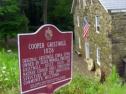
The Skylands Region officially encompasses Hunterdon, Morris, Somerset, Sussex and Warren counties; the northwestern part of the Passaic County fits in with the Skylands Region, but it is part of the Gateway Region and not the Skylands Region. One could also say that the westernmost part of Bergen (in the Ramapo Mountains) is also part of the Skylands. The area features uplifted land, rolling hills and mountainous characteristics of North Jersey. The region contains 60,000 acres (240 km²) of state parkland and a diverse geography filled with lakes, rivers, and picturesque hills.

Climate

This region is considered by Köppen to be Humid Continental (Dfb).

Places and events

See also

Related Research Articles

<span class="mw-page-title-main">Sussex County, New Jersey</span> County in New Jersey, United States

Sussex County is the northernmost county in the U.S. state of New Jersey. Its county seat is Newton. It is part of the New York metropolitan area and is part of New Jersey's Skylands Region. As of the 2020 census, the county was the state's 17th-most-populous county, with a population of 144,221, a decrease of 5,044 (−3.4%) from the 2010 census count of 149,265, which in turn reflected an increase of 5,099 (+3.5%) over the 144,166 persons at the 2000 census. Based on 2020 census data, Vernon Township was the county's largest in both population and area, with a population of 22,358 and covering an area of 70.59 square miles (182.8 km2). The county is part of the North Jersey region of the state.

Augusta is an unincorporated community located within Frankford Township, in Sussex County, New Jersey, United States. As of the 2010 United States Census, the population for the ZIP Code Tabulation Area 07822 was 887.

<span class="mw-page-title-main">Musconetcong River</span> River in New Jersey, United States

The Musconetcong River is a 45.7-mile-long (73.5 km) tributary of the Delaware River in northwestern New Jersey in the United States. It flows through the rural mountainous country of northwestern New Jersey. The name derives from the Lenape words moschakgeu meaning "clear" and hannek meaning "stream". Part of it is a National Wild and Scenic River.

<span class="mw-page-title-main">Lake Hopatcong</span> Natural lake, reservoir in New Jersey, United States

Lake Hopatcong is the largest freshwater body in New Jersey, United States, about 4 square miles (10 km2) in area. Located 30 miles (48 km) from the Delaware River and 40 miles (64 km) from Manhattan, New York City, the lake forms part of the border between Sussex and Morris counties in the state's northern highlands region.

<span class="mw-page-title-main">Pequest River</span> River in United States of America

The Pequest River is a 35.7-mile-long (57.5 km) tributary of the Delaware River in the Skylands Region in northwestern New Jersey in the United States.

<span class="mw-page-title-main">Paulins Kill</span> River in New Jersey, United States

The Paulins Kill is a 41.6-mile (66.9 km) tributary of the Delaware River in northwestern New Jersey in the United States. With a long-term median flow rate of 76 cubic feet of water per second (2.15 m³/s), it is New Jersey's third-largest contributor to the Delaware River, behind the Musconetcong River and Maurice River. The river drains an area of 176.85 square miles (458.0 km2) across portions of Sussex and Warren counties and 11 municipalities. It flows north from its source near Newton, and then turns southwest. The river sits in the Ridge and Valley geophysical province.

<span class="mw-page-title-main">Papakating Creek</span> Creek in Sussex County, New Jersey, U.S.

Papakating Creek is a 20.1-mile-long (32.3 km) tributary of the Wallkill River located in Frankford and Wantage townships in Sussex County, New Jersey in the United States. The creek rises in a small swamp located beneath the eastern face of Kittatinny Mountain in Frankford and its waters join the Wallkill to the east of Sussex borough.

<span class="mw-page-title-main">High Point State Park</span> State park in New Jersey

High Point State Park is a state park straddling the border of Wantage Township and Montague Township in Sussex County, within the Skylands Region of northwestern New Jersey, United States, near the border with New York State and Pennsylvania. The park covers 15,413 acres (62.37 km2). Part of the Kittatinny Mountains, the highest point in the state of New Jersey, the aptly named High Point, sits in the northern reaches of the park, at elevation 1,803 feet (550 m). Route 23 skirts the park and provides access for visitors from the New Jersey suburbs and from points in New York. The park is administered by the New Jersey Division of Parks and Forestry.

<span class="mw-page-title-main">Schooley's Mountain</span>

Schooley's or, officially, Schooleys Mountain is a mountain ridge in northern New Jersey that stretches from Lake Hopatcong in the north to Hampton in the south. It is centrally located within the southern Highlands, positioned almost equidistantly from the Kittatinny Valley in the west and the Piedmont plateau in the east. Schooley's Mountain is also one of the largest ridges in a group of geologically similar and parallel mountains, which include Allamuchy Mountain, Pohatcong Mountain, Scotts Mountain, and Jenny Jump Mountain.

<span class="mw-page-title-main">Allamuchy Mountain State Park</span> State park in New Jersey, United States

Allamuchy Mountain State Park is located in Allamuchy Township and Byram Township in the Allamuchy Mountain region of New Jersey. The park is operated and maintained by the New Jersey Division of Parks and Forestry. There are more than 20 miles (32 km) of unmarked trails in the northern section of Allamuchy, and 14 miles (23 km) of marked multi-use trails.

<span class="mw-page-title-main">Geography of New Jersey</span> Overview of the geography of New Jersey

New Jersey is a state within the United States of America that lies on the north eastern edge of the North American continent. It shares a land border with the state of New York along the north, ratified by both states after the New York – New Jersey Line War, which is its only straight line border. New Jersey is slightly larger than the country of Kuwait.

<span class="mw-page-title-main">Sourland Mountain</span> Geological formation in New Jersey, US

Sourland Mountain is a 17 miles (27 km) long ridge in central New Jersey, U.S., extending from the Delaware River at Lambertville to the western end of Hillsborough Township near the community of Neshanic, through Montgomery Township and into Hopewell Township in Mercer County. It comprises the largest contiguous forest in Central Jersey, nearly 90 square miles (233 km2) in area. The highest point is only 568 feet (173 m) above sea level, but the way it rises steeply from the surrounding farmland has earned it the title of 'mountain'. The ridge itself sits within a larger area of rough terrain called The Sourlands.

<span class="mw-page-title-main">Pochuck Mountain</span>

Pochuck Mountain is a ridge in the New York-New Jersey Highlands region of the Appalachian Mountains. Pochuck Mountain's summit and most of its peaks lie within Vernon Township, Sussex County, New Jersey, although the south-western portion of the ridge lies within Hardyston Township, and the north-eastern tip of the ridge extends over the New York state line into Orange County. The ridge marks the eastern edge of the Great Appalachian Valley, and it divides the watersheds of the Wallkill River and its tributary Pochuck Creek. The two rivers meet at Pochuck Neck, marking the terminus of the ridge.

<span class="mw-page-title-main">Kittatinny Valley</span>

The Kittatinny Valley is a section of the Great Appalachian Valley in Sussex and Warren counties in northwestern New Jersey that is bounded on the northwest by Kittatinny Mountain, and in the southeast by the New Jersey Highlands region. The valley is roughly 40 miles (64 km) long, with a breadth of 10 to 13 miles.

<span class="mw-page-title-main">Sussex Branch Trail</span>

The Sussex Branch Trail is a rail trail in New Jersey, United States, with a total length of 20 miles (32 km).

<span class="mw-page-title-main">Minisink</span>

The Minisink or Minisink Valley is a loosely defined geographic region of the Upper Delaware River valley in northwestern New Jersey, northeastern Pennsylvania and New York.

<span class="mw-page-title-main">New York–New Jersey Highlands</span> Geological formation

The New York – New Jersey Highlands is a geological formation composed primarily of Precambrian igneous and metamorphic rock running from the Delaware River near Musconetcong Mountain, northeast through the Skylands Region of New Jersey along the Bearfort Ridge and the Ramapo Mountains, Sterling Forest, Harriman and Bear Mountain State Parks in New York, to the Hudson River at Storm King Mountain. The northern region is also known as the Hudson Highlands and the southern as the New Jersey Highlands. A broader definition would extend the region west to Reading, Pennsylvania, and east to the Housatonic River in Connecticut, encompassing the Reading Prong.

<span class="mw-page-title-main">Allamuchy Mountain</span> Mountain in New Jersey, USA

Allamuchy Mountain is a mountain in Sussex and Warren Counties, New Jersey. The major peak rises to 1,222 feet (372 m), and is located in Byram Township. The mountain also covers portions of Allamuchy Township in Warren County and Green Township in Sussex County. It overlooks the Musconetcong River to the southeast, and forms part of the divide between that river and the Pequest to the northwest. It is part of the New York–New Jersey Highlands of the Reading Prong.

References

  1. "NJ Cities and Regions: Destinations to Discover | VisitNJ.org".

40°41′35″N74°51′59″W / 40.6931°N 74.8663°W / 40.6931; -74.8663