Kittatinny Valley State Park

Last updated

Kittatinny Valley State Park
Lake Aeroflex, Kittatinny Valley State Park, NJ.jpg
Kayakers on Lake Aeroflex
Location map of Sussex County, New Jersey.svg
Red pog.svg
USA New Jersey location map.svg
Red pog.svg
Usa edcp location map.svg
Red pog.svg
Location Andover Township
Andover Borough
Coordinates 41°0′59″N74°44′38″W / 41.01639°N 74.74389°W / 41.01639; -74.74389 [1]
Area5,656-acre (22.89 km2)
Established1994
Operated by New Jersey Division of Parks and Forestry
Website Official website OOjs UI icon edit-ltr-progressive.svg

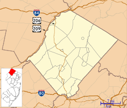
Kittatinny Valley State Park is located in Andover Township and extends into Andover Borough, New Jersey. Features include Glacial lakes, limestone outcroppings, former railroads, and a small airport. Lake Aeroflex and Gardner's Pond form part of the headwaters of the Pequest River and are excellent for fishing and boating. The park is home to a variety of wildlife such as whitetail deer, wild turkeys, a variety of songbirds, beavers, muskrats, and squirrels. The park is operated and maintained by the New Jersey Division of Parks and Forestry. [1]
Contents

Park programs

The Slater House 265 Limecrest Road, Andover Township, NJ.jpg
The Slater House

The park offers many different programs year-round for children and adults. Nature hikes, mountain bike rides and talks are conducted by the park staff/volunteers and are scheduled for each weekend. These include weekly walks, such as Wednesday Walkers, full moon hikes every full moon, and special hikes and programs throughout the year. [1] The Slater House was built in 1874 by Charles K. Slater. Once the park administrative office, it now is the District 3 Headquarters of the New Jersey State Park Police. [2]

Fishing

Lake Aeroflex (New Wawayanda Lake)

Lake Aeroflex, also known as New Wawayanda Lake, [3] is 119 acres (0.48 km2) in area and accessible via the shoreline or boat launch ramp. The New Jersey Division of Fish and Wildlife stocks Lake Aeroflex annually with brown and rainbow trout. Small boats may be carried by hand or small cart and launched from the shore. There is no motor vehicle access. The lake is designated a “holdover trout lake.” During the winter months, Lake Aeroflex is open for ice-fishing (conditions permitting).

Gardner’s Pond

Gardner's Pond is a 39-acre (160,000 m2) pond that can be accessed through the small plane parking area of the Aeroflex–Andover Airport. Small boats may be carried by hand or small cart and launched from the shore. There is no motor vehicle access. During the winter months, Gardner's Pond is open for ice-fishing (conditions permitting).

Twin Lakes

Twin Lakes is a 29-acre (120,000 m2) lake located off of Goodale Road in Andover Township. Fishermen can access the lake using the car-top boat launch or from the shoreline. During the winter months, Twin Lakes is open for ice-fishing (conditions permitting).

White's Pond

White's Pond is accessible from the Sussex Branch Trail or from Goodale Road and is open for shoreline fishing only. During the winter months, White's Pond is open for ice-fishing (conditions permitting).

Hunting

Hunting is permitted in specific areas within the park. There is no hunting allowed on or from the trails. Areas of the park to the west of Goodale Road and to the east of Limecrest Road are open for all hunting seasons. (Subject to rules and regulations of the New Jersey Department of Environmental Protection).

Picnicking

A limited number of picnic tables and grills are available near the parking area on Limecrest Road. Other picnic tables are scattered through the park.

Mountain biking

There are over eight miles (13 km) of rugged mountain bike trails available. Volunteers from the Bulldog Mountain Bike Team regularly maintain trails in preparation for mountain bike races held in the park each year. The terrain is varied enough to be challenging to both novice and expert riders. All trail ratings and descriptions are made by the New Jersey Department of Environmental Protection which oversees the State Park system.

Transportation

Aeroflex-Andover Airport, owned and managed by the New Jersey Forest Fire Service, is located within the park. It is both a general aviation airport and an airbase for aerial wildfire suppression.

Trails

Sussex Branch Trail

Sussex Branch Trail passing through the "Slate Cut" Sussex Branch Trail, Andover Township, NJ - railway cutting.jpg
Sussex Branch Trail passing through the "Slate Cut"

The 20-mile (32 km) Sussex Branch Trail passes through swamps, lakes, fields and several communities. Many features from its previous existence as a railroad can be exhibited. Among those features are graded fill areas, cuts through bedrock, underpasses that allowed the passage of farm equipment and dairy cattle from one side of the tracks to the other, and bridges crossing the Pequest River or Paulins Kill. The flat cinder base of the trail permits multiple uses including hiking, horseback riding, biking, cross-country skiing and dog sledding. The trail provides access for fishing and for wheelchairs in certain areas. [1] The Sussex Branch Trail also crosses through Allamuchy Mountain State Park.

Related Research Articles

<span class="mw-page-title-main">Delaware Water Gap</span> Geological feature along the Delaware River

Delaware Water Gap is a water gap on the border of the U.S. states of New Jersey and Pennsylvania where the Delaware River cuts through a large ridge of the Appalachian Mountains.

<span class="mw-page-title-main">Round Valley Reservoir</span> Reservoir in Clinton Township, New Jersey

The Round Valley Reservoir in Clinton Township in Hunterdon County, New Jersey, United States, was formed in 1960 when the New Jersey Water Authority constructed two large dams and flooded a large valley. The reservoir is named after the naturally formed circular valley surrounded by Cushetunk Mountain. The deep valley was caused by erosion of the soft sedimentary rock. The surrounding ridges of Cushetunk Mountain endure because they were underlaid with dense and durable volcanic rock diabase that cooled slowly under the surface of the earth. The reservoir covers what used to be a farming community, with remains of a school and a church on the lake floor among other buildings.

<span class="mw-page-title-main">Cave Run Lake</span> Man-made lake in Kentucky, United States

Cave Run Lake, located south of Morehead, Kentucky, USA along Kentucky Route 801, is an 8,270-acre (33 km2) reservoir built by the U.S. Army Corps of Engineers. The 148 ft (45 m), half-mile dam construction began in 1965 and was completed in 1973. Cave Run Lake is in the northern part of the Daniel Boone National Forest. Cave Run Lake provides flood protection to the lower Licking River valley, supplies water to the area's communities, improves the Licking River's water flow conditions, and offers a habitat for various species of fish and wildlife. It is in Rowan, Morgan, Menifee, and Bath counties.

<span class="mw-page-title-main">Moraine State Park</span> State park in Pennsylvania, United States

Moraine State Park is a Pennsylvania state park on 16,725 acres (6,768 ha) in Brady, Clay, Franklin, Muddy Creek, and Worth townships in Butler County, Pennsylvania.

<span class="mw-page-title-main">Clarence Fahnestock State Park</span>

Clarence Fahnestock Memorial State Park, also known as Fahnestock State Park, is a 22.4-square-mile (58 km2) state park located in Putnam and Dutchess counties, New York. The park has hiking trails, a beach on Canopus Lake, and fishing on four ponds and two lakes. Spanning parts of the towns of Putnam Valley, Kent, and Carmel, most of the park is situated in northern Putnam County between the Taconic State Parkway and U.S. Route 9.

<span class="mw-page-title-main">Ramapo Mountain State Forest</span> Forest in New Jersey, United States

Ramapo Mountain State Forest is a 4,200-acre (17 km2) state forest in Bergen and Passaic Counties in New Jersey. The park is operated and maintained by the New Jersey Division of Parks and Forestry.

<span class="mw-page-title-main">Delaware Water Gap National Recreation Area</span> Protected area

Delaware Water Gap National Recreation Area is a 70,000-acre (28,000 ha) national recreation area administered by the National Park Service in northwest New Jersey and northeast Pennsylvania. It is centered around a 40-mile (64 km) stretch of the Delaware River designated the Middle Delaware National Scenic River. At the area's southern end lays the Delaware Water Gap, a dramatic mountain pass where the river cuts between Blue Mountain and Kittatinny Mountain.

Taconic State Park is located in Columbia and Dutchess County, New York abutting Massachusetts and Connecticut within the Taconic Mountains. The state park is located off New York State Route 344 south of Interstate 90 and 110 miles (180 km) north of New York City. It features camping, hiking, bicycling, hunting, cross county skiing and other recreational opportunities.

<span class="mw-page-title-main">Swartswood State Park</span> State park in Sussex County, New Jersey

Swartswood State Park is a 3,460-acre (14.0 km2) protected area located in the Swartswood section of Stillwater and Hampton townships in Sussex County, New Jersey, in the United States. Established in 1915 by the state's Forest Park Reservation Commission, it was the first state park established by the state of New Jersey for the purposes of recreation at the state's third-largest freshwater lake. Today, Swartswood State Park is operated and maintained by the New Jersey Division of Parks and Forestry.

<span class="mw-page-title-main">Dunn State Park</span>

Dunn State Park is a public recreation area surrounding a 20-acre (8.1 ha) pond in Gardner, Massachusetts. The state park covers 132 acres (53 ha) and is managed by the Department of Conservation and Recreation.

<span class="mw-page-title-main">Stokes State Forest</span>

Stokes State Forest is a state park located in Sandyston, Montague and Frankford in Sussex County, New Jersey, United States. Stokes comprises 16,447 acres (66.56 km2) of mountainous woods in the Kittatinny Mountains, extending from the southern boundary of High Point State Park southwestward to the eastern boundary of the Delaware Water Gap National Recreation Area. The park is operated and maintained by the New Jersey Division of Parks and Forestry.

<span class="mw-page-title-main">Beltzville State Park</span> State park in Pennsylvania, United States

Beltzville State Park is a 2,972.39-acre (1,202.88 ha) Pennsylvania state park in Franklin and Towamensing townships, Carbon County, Pennsylvania in the United States. The park opened in 1972, and was developed around the U.S. Army Corps of Engineers flood control project Beltzville Dam on Pohopoco Creek. The village of Big Creek Valley was vacated in 1966 to make way for Beltzville Lake. Beltzville Lake is a 951.5 acres (385.1 ha) with 19.8 miles (31.9 km) of shoreline. Beltzville State Park is 5 miles (8.0 km) east of Lehighton just off U.S. Route 209. The park is at an elevation of 633 feet (193 m).

<span class="mw-page-title-main">Lackawanna State Park</span> State park in Pennsylvania, United States

Lackawanna State Park is a 1,445-acre (585 ha) Pennsylvania state park in Benton and North Abington Townships, Lackawanna County, Pennsylvania in the United States. Lake Lackawanna, a 198-acre (80 ha) man-made lake, is the central focus of recreation at the park. Lackawanna State Park is located near Dalton on Pennsylvania Route 524 just off exit 199 of Interstate 81.

<span class="mw-page-title-main">Silver Springs State Fish and Wildlife Area</span> Park in Kendall county, Illinois, US

Silver Springs State Fish and Wildlife Area is an Illinois state park on 1,350 acres (550 ha) in Kendall County, Illinois, United States. The park was established in the late 1960s and is named for the natural spring within its boundaries. The park has two artificial lakes and the Fox River flows through the northern end of the park. Silver Springs hosts a variety of activities including fishing, hunting, boating and hiking. The park has areas of native prairie restoration, a sledding hill and a seven-mile (11 km) equestrian trail. The prairie restoration areas hold many species of plants including lead plant, and purple coneflower.

<span class="mw-page-title-main">Aeroflex–Andover Airport</span> Airport in Sussex County, New Jersey, United States

Aeroflex–Andover Airport is a public-use airport located two nautical miles (3.704 km) north of Andover within Kittatinny Valley State Park in Sussex County, New Jersey, United States. The airport is publicly owned by the New Jersey Forest Fire Service and used as a base for aerial wildfire suppression.

<span class="mw-page-title-main">Alum Creek State Park</span> State park in Ohio, United States

Alum Creek State Park is a 4,630-acre (1,870 ha) Ohio state park in Delaware County, Ohio, in the United States. Alum Creek Lake was constructed from 1970 to 1974 as part of the Flood Control Act of 1962. Alum Creek Dam was constructed on Alum Creek, a tributary of Big Walnut Creek, which drains into the Scioto River. Alum Creek Reservoir holds 3,387 acres (1,371 ha) of water and is open to fishing, boating, ice fishing, ice boating and swimming. The park is just north of the state capital of Columbus and contains the remnants of a settlement by freed slaves that arrived in Ohio from North Carolina.

<span class="mw-page-title-main">Kittatinny Valley</span>

The Kittatinny Valley is a section of the Great Appalachian Valley in Sussex and Warren counties in northwestern New Jersey that is bounded on the northwest by Kittatinny Mountain, and in the southeast by the New Jersey Highlands region. The valley is roughly 40 miles (64 km) long, with a breadth of 10 to 13 miles.

<span class="mw-page-title-main">Housatonic Range Trail</span>

The Housatonic Range Trail is a 6.2-mile (10.0 km) Blue-Blazed hiking trail in the Housatonic Valley Region of Litchfield County in the town of New Milford in the Candlewood Mountain and Gaylordsville Connecticut sections. The north-south axis of the trail parallels the Housatonic River through private land and land trust parcels. The Housatonic Range Trail is maintained largely through the efforts of the Connecticut Forest and Park Association, which provides online Blue Trail maps.

<span class="mw-page-title-main">Sussex Branch Trail</span>

The Sussex Branch Trail is a rail trail in New Jersey, United States, with a total length of 20 miles (32 km).

References

  1. 1 2 3 4 "Kittatinny Valley State Park". New Jersey State Park Service.
  2. "The History of Kittatinny Valley State Park" (PDF). New Jersey State Park Service.
  3. "Landlocked Salmon Arrive in New Jersey". New Jersey Department of Environmental Protection. Retrieved June 10, 2020.