An estuary is a partially enclosed coastal body of brackish water with one or more rivers or streams flowing into it, and with a free connection to the open sea. Estuaries form a transition zone between river environments and maritime environments and are an example of an ecotone. Estuaries are subject both to marine influences such as tides, waves, and the influx of saline water, and to fluvial influences such as flows of freshwater and sediment. The mixing of seawater and freshwater provides high levels of nutrients both in the water column and in sediment, making estuaries among the most productive natural habitats in the world.

The National Estuarine Research Reserve System is a network of 30 protected areas established by partnerships between the National Oceanic and Atmospheric Administration (NOAA) and coastal states. The reserves represent different biogeographic regions of the United States. The National Estuarine Research Reserve System protects more than 1.3 million acres of coastal and estuarine habitats for long-term research, water-quality monitoring, education, and coastal stewardship.

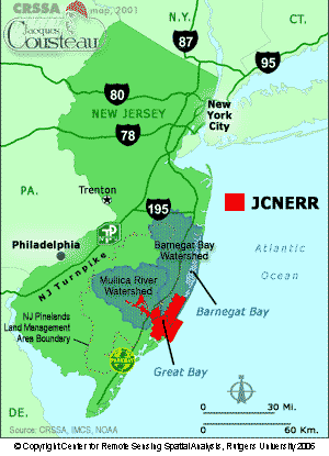
The Mullica River is a 50.6-mile-long (81.4 km) river in southern New Jersey in the United States. The Mullica was once known as the Little Egg Harbor River.

Coos Bay is an estuary where the Coos River enters the Pacific Ocean, the estuary is approximately 12 miles long and up to two miles wide. It is the largest estuary completely within Oregon state lines. The Coos Bay watershed covers an area of about 600 square miles and is located in northern Coos County, Oregon, in the United States. The Coos River, which begins in the Oregon Coast Range, enters the bay from the east. From Coos River, the bay forms a sharp loop northward before arching back to the south and out to the Pacific Ocean. Haynes Inlet enters the top of this loop. South Slough branches off from the bay directly before its entrance into the Pacific Ocean. The bay was formed when sea levels rose over 20,000 years ago at the end of the Last Glacial Maximum, flooding the mouth of the Coos River. Coos Bay is Oregon's most important coastal industrial center and international shipping port, with close ties to San Francisco, the Columbia River, Puget Sound and other major ports of the Pacific rim.

Wells National Estuarine Research Reserve, also known as Wells Reserve, is a National Estuarine Research Reserve located in Wells, Maine.

Great Bay is a tidal estuary located in Strafford and Rockingham counties in eastern New Hampshire, United States. The bay occupies over 6,000 acres (24 km2), not including its several tidal river tributaries. Its outlet is at Hilton Point in Dover, New Hampshire, where waters from the bay flow into the Piscataqua River, thence proceeding southeast to the Atlantic Ocean near Portsmouth. The northern end of the bay, near its outlet, is referred to as Little Bay.

Great Bay is located in southern New Jersey's Atlantic Coastal Plain in Ocean and Atlantic Counties, about ten miles (16 km) north of Atlantic City and is about 5.5 miles northwest of Brigantine, and 5.5 miles southwest of Beach Haven. The Mullica River flows into the bay, and together they form the Mullica River - Great Bay estuary habitat. The bay is connected to the Atlantic Ocean via the Little Egg Inlet. Great Bay is considered one of the least-disturbed marine wetlands habitats in the northeastern United States.

In 1999, the Guana Tolomato Matanzas National Estuarine Research Reserve was designated in St. Johns and Flagler counties, Florida as a part of the National Oceanic and Atmospheric Administration (NOAA) National Estuarine Research Reserve (NERR) system. The GTM Research Reserve represents the east Florida sub-region of the Carolinian bioregion. It is one of 30 NERRs in 23 states and one territory. GTM is one of three NERRs in Florida and is administered on behalf of the state by the Florida Department of Environmental Protection's Florida Coastal Office as part of a network that includes forty-one aquatic preserves, three NERRs, a National Marine Sanctuary, the Coral Reef Conservation Program and the Florida Oceans and Coastal Council. Additional interests are held in the research and management of the GTM and connected preserved or conserved lands including:

Elkhorn Slough is a 7-mile-long (11 km) tidal slough and estuary on Monterey Bay in Monterey County, California. It is California's second largest estuary and the United States' first estuarine sanctuary. The community of Moss Landing and the Moss Landing Power Plant are located at the mouth of the slough on the bay.

The San Francisco Bay National Estuarine Research Reserve is one of 27 reserves established as part of the United States National Estuarine Research Reserve System. The reserve is used to promote San Francisco Bay wetlands and estuary research, education, and stewardship.

The Ashepoo Combahee Edisto Basin National Estuarine Research Reserve is a 140,000-acre (570 km2) reserve area located in the ACE Basin, one of the largest undeveloped estuaries on the Atlantic coast of the United States. It is named for the Ashepoo, Combahee and Edisto Rivers, which flow past cypress swamps, historic plantation houses, old rice fields and tidal marshes to meet at South Carolina's biologically rich St. Helena Sound.

The North Inlet-Winyah Bay National Estuarine Research Reserve, in the U.S. State of South Carolina, features the salt marshes and ocean dominated tidal creeks of the North Inlet Estuary plus the brackish waters and marshes of the adjacent Winyah Bay Estuary. North Inlet is a relatively pristine system in which water and habitat quality are much higher than those in Winyah Bay. As the estuary with the third largest watershed on the east coast, Winyah Bay has been greatly influenced by agriculture, industry and other human activities. More than 90 percent of North Inlet's watershed is in its natural forested state
The Great Bay National Estuarine Research Reserve encompasses a diversity of land and water areas around Great Bay, an estuary in southeastern New Hampshire. Protected lands cover 10,235 acres (4,142 ha), including approximately 7,300 acres (3,000 ha) of open water and wetlands that include salt marshes, rocky shores, bluffs, woodlands, open fields, and riverine systems and tidal waters.
Kachemak Bay National Estuarine Research Reserve, on the western coast of the Kenai Peninsula in Alaska, is part of the National Estuarine Research Reserve System and is managed jointly by the U.S. National Oceanic and Atmospheric Administration and the Alaska Department of Fish and Game. Covering more than 370,000 acres (1,500 km2), it is the largest reserve in the system, encompassing one of the most diverse and intensively used estuaries in Alaska. The local community pursued the designation of Kachemak Bay as a National Estuarine Research Reserve to preserve the lifestyle and economy of the region.
The Mission-Aransas National Estuarine Research Reserve is a large contiguous complex of wetland, terrestrial, and marine environments on the Texas Coastal Bend in the United States. Named for the two major rivers that flow into the area, the reserve contains public and private lands and waters. The land is primarily coastal prairie with unique oak motte habitats. The wetlands include riparian habitat, freshwater marshes, and saltwater marshes. Within the water areas, the bays are large, open, and include extensive tidal flats, seagrass meadows, mangroves, and oyster reefs. These unique and diverse estuarine habitats in the western Gulf of Mexico support a host of endangered and threatened species including the endangered whooping crane.
The Weeks Bay National Estuarine Research Reserve is a field laboratory and research facility along Weeks Bay estuary, about 6,000 acres (2,400 ha) in size. It receives freshwater from the Magnolia and Fish Rivers, and drains a 198 square miles (510 km2) watershed into the portion of Mobile Bay via a narrow opening. This sub-estuary of Mobile Bay averages just 4.8 ft deep and is fringed with marsh and swamp. The reserve lands also include upland and bottomland hardwood forests, freshwater marsh, submerged aquatic vegetation and unique bog habitats. Weeks Bay is a critical nursery for shrimp, bay anchovy, blue crab and multitudes of other fish, crustaceans and shellfish that support robust commercial fisheries providing $450 million/year for Alabama.
Designated in 1991, the Chesapeake Bay National Estuarine Research Reserve - Virginia (CBNERR-VA) is one of 29 protected areas that make up the National Estuarine Research Reserve System (NERRS). Established to promote informed management of the nation's estuaries and coastal habitats.
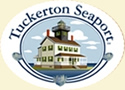
The Tuckerton Seaport is a working maritime village and museum located in Tuckerton, a borough situated on the Jersey Shore, within Ocean County in the U.S. state of New Jersey. The 40-acre (160,000 m2) site, which opened in May 2000, features 17 historic and recreated buildings connected by a boardwalk, a maritime forest and wetlands nature trail. The seaport, which is a member of the Council of American Maritime Museums, celebrated its 10th anniversary in 2010.
Michael J. Kennish is an American marine scientist and a research professor in the Institute of Marine and Coastal Sciences at Rutgers University in New Brunswick, New Jersey. He is best known for his work on the effects of human activities on estuarine and marine environments.
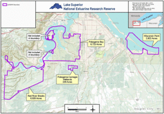
The Lake Superior National Estuarine Research Reserve includes land and water areas along the St. Louis River and Lake Superior in Douglas County, in the northwest corner of Wisconsin, United States. It is one of 29 National Estuarine Research Reserves. The Reserve is operated as a program of the Natural Resources Institute of the University of Wisconsin-Madison Division of Extension. It has an area of 16,697 acres (6,757 ha), and was designated in 2010.