
The National Estuarine Research Reserve System is a network of 29 protected areas established by partnerships between the National Oceanic and Atmospheric Administration (NOAA) and coastal states. The reserves represent different biogeographic regions of the United States. The National Estuarine Research Reserve System protects more than 1.3 million acres of coastal and estuarine habitats for long-term research, water-quality monitoring, education, and coastal stewardship.

The Coastal Zone Management Act of 1972 is an Act of Congress passed in 1972 to encourage coastal states to develop and implement coastal zone management plans (CZMPs). This act was established as a United States National policy to preserve, protect, develop, and where possible, restore or enhance, the resources of the Nation's coastal zone for this and succeeding generations.

Wells National Estuarine Research Reserve, located in Wells, Maine, USA, is 2,250 acres (9.1 km2) of protected land headquartered at a restored saltwater farm called Laudholm. As a National Estuarine Research Reserve, the Wells Reserve works to expand knowledge of coasts and estuaries, engage people in environmental learning, and involve communities in conservation, all with a goal of protecting and restoring coastal ecosystems around the Gulf of Maine. Wells Reserve funding is largely through the National Oceanic and Atmospheric Administration and the nonprofit Laudholm Trust.
The Chesapeake Bay National Estuarine Research Reserve is an estuary reserve in Maryland.
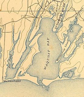
Waquoit Bay is a public national estuary, which is typically used as a research reserve. It is a part of Nantucket Sound and is located on the southern shore of Cape Cod in Massachusetts, USA. This bay forms the border of the towns of Falmouth, Massachusetts and Mashpee.
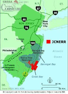
The Jacques Cousteau National Estuarine Research Reserve, located in southeastern New Jersey, encompasses over 110,000 acres (450 km²) of terrestrial, wetland and aquatic habitats within the Mullica River-Great Bay Ecosystem.
Rookery Bay Reserve protects 110,000 acres of coastal lands and waters at the northern end of the Ten Thousand Islands on the gulf coast of Florida, Rookery Bay National Estuarine Research Reserve represents one of the few remaining undisturbed mangrove estuaries in North America.
In 1999, the Guana Tolomato Matanzas National Estuarine Research Reserve was designated in St. Johns and Flagler counties, Florida as a part of the National Oceanic and Atmospheric Administration (NOAA) National Estuarine Research Reserve (NERR) system. The GTM Research Reserve represents the east Florida sub-region of the Carolinian bioregion. It is one of 29 NERRs in 23 states and one territory. GTM is one of three NERRs in Florida, and is administered on behalf of the state by the Florida Department of Environmental Protection's Florida Coastal Office as part of a network that includes forty-one aquatic preserves, three NERRs, a National Marine Sanctuary, the Coral Reef Conservation Program and the Florida Oceans and Coastal Council.

Elkhorn Slough is a 7-mile-long (11 km) tidal slough and estuary on Monterey Bay in Monterey County, California. The community of Moss Landing and the Moss Landing Power Plant are located at the mouth of the slough on the bay.

The San Francisco Bay National Estuarine Research Reserve is one of 27 reserves established as part of the United States National Estuarine Research Reserve System. The reserve is used to promote San Francisco Bay wetlands and estuary research, education, and stewardship.

The Ashepoo Combahee Edisto Basin National Estuarine Research Reserve is a 140,000-acre (570 km2) reserve area located in the ACE Basin, one of the largest undeveloped estuaries on the Atlantic coast of the United States. It is named for the Ashepoo, Combahee and Edisto Rivers, which flow past cypress swamps, historic plantation houses, old rice fields and tidal marshes to meet at South Carolina’s biologically rich St. Helena Sound.

The North Inlet-Winyah Bay National Estuarine Research Reserve, in the U.S. State of South Carolina, features the salt marshes and ocean dominated tidal creeks of the North Inlet Estuary plus the brackish waters and marshes of the adjacent Winyah Bay Estuary. North Inlet is a relatively pristine system in which water and habitat quality are much higher than those in Winyah Bay. As the estuary with the third largest watershed on the east coast, Winyah Bay has been greatly influenced by agriculture, industry and other human activities. More than 90 percent of North Inlet's watershed is in its natural forested state

The Delaware National Estuarine Research Reserve consists of two unique components, one on Blackbird Creek and the other on the St. Jones River. Freshwater wetlands, ponds and forest lands dominate the Blackbird Creek component. The St. Jones component is dominated by salt marsh and open water habitats of the Delaware Bay.
The Mission-Aransas National Estuarine Research Reserve is a large contiguous complex of wetland, terrestrial, and marine environments on the Texas Coastal Bend in the United States. Named for the two major rivers that flow into the area, the reserve contains public and private lands and waters. The land is primarily coastal prairie with unique oak motte habitats. The wetlands include riparian habitat, freshwater marshes, and saltwater marshes. Within the water areas, the bays are large, open, and include extensive tidal flats, seagrass meadows, mangroves, and oyster reefs. These unique and diverse estuarine habitats in the western Gulf of Mexico support a host of endangered and threatened species including the endangered whooping crane.
Old Woman Creek National Estuarine Research Reserve is the smallest reserve in the National Estuarine Research Reserve System at 573 acres (232 ha). It is one of two Great Lakes-type, freshwater estuaries in the system; the other being Lake Superior National Estuarine Research Reserve. Located in Erie County, Ohio near Sandusky, the reserve features freshwater marshes, swamp forests, a barrier beach, upland forest, estuarine waters, stream and nearshore Lake Erie. Photographic atlases containing descriptions and identifications of many of the invertebrates found at Old Woman Creek have been prepared by Dr. Kenneth Krieger of the National Center for Water Quality Research at Heidelberg University.

The Sapelo Island National Estuarine Research Reserve is a 6,110-acre (2,470 ha) coastal plain estuary, located in the U.S. State of Georgia, protected on its seaward side by a Pleistocene barrier island. It was established in 1976.

Waquoit Bay National Estuarine Research Reserve (WBNERR) encompasses open waters, barrier beaches, marshlands and uplands on the south shore of Cape Cod in the towns of Falmouth and Mashpee. The park is managed by the Department of Conservation and Recreation (DCR) and the National Oceanic and Atmospheric Administration.
The Weeks Bay National Estuarine Research Reserve is a field laboratory and research facility along Weeks Bay estuary, about 6,000 acres (2,400 ha) in size. It receives freshwater from the Magnolia and Fish Rivers, and drains a 198 square miles (510 km2) watershed into the portion of Mobile Bay via a narrow opening. This sub-estuary of Mobile Bay averages just 4.8 ft deep and is fringed with marsh and swamp. The reserve lands also include upland and bottomland hardwood forests, freshwater marsh, submerged aquatic vegetation and unique bog habitats. Weeks Bay is a critical nursery for shrimp, bay anchovy, blue crab and multitudes of other fish, crustaceans and shellfish that support robust commercial fisheries providing $450 million/year for Alabama.
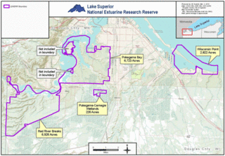
The Lake Superior National Estuarine Research Reserve is located along the St. Louis River in Douglas County, the northwest corner of Wisconsin, United States. It is one of many National Estuarine Research Reserves. It has an area of 16,697 acres (6,757 ha), and was designated in 2010.


