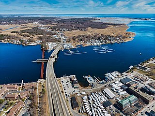
Laconia is a city in Belknap County, New Hampshire, United States. The population was 16,871 at the 2020 census, up from 15,951 at the 2010 census. It is the county seat of Belknap County. Laconia, situated between Lake Winnipesaukee and Lake Winnisquam, includes the villages of Lakeport and Weirs Beach. Each June, the city hosts Laconia Motorcycle Week, also more simply known as "Bike Week", one of the country's largest rallies.

New London is a town in Merrimack County, New Hampshire, United States. The population was 4,400 at the 2020 census. The town is the home of Colby–Sawyer College, site of the Gordon Research Conferences since 1947.
The Merrimack River is a 117-mile-long (188 km) river in the northeastern United States. It rises at the confluence of the Pemigewasset and Winnipesaukee rivers in Franklin, New Hampshire, flows southward into Massachusetts, and then flows northeast until it empties into the Gulf of Maine at Newburyport. From Pawtucket Falls in Lowell, Massachusetts, onward, the Massachusetts–New Hampshire border is roughly calculated as the line three miles north of the river.
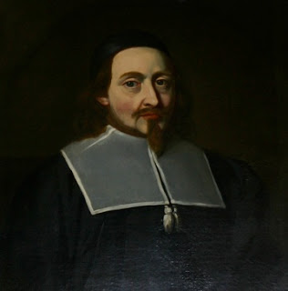
John Endecott, regarded as one of the Fathers of New England, was the longest-serving governor of the Massachusetts Bay Colony, which became the Commonwealth of Massachusetts. He served a total of 16 years, including most of the last 15 years of his life. When not serving as governor, he was involved in other elected and appointed positions from 1628 to 1665 except for the single year of 1634.

The Middlesex Canal was a 27-mile (44-kilometer) barge canal connecting the Merrimack River with the port of Boston. When operational it was 30 feet wide, and 3 feet deep, with 20 locks, each 80 feet long and between 10 and 11 feet wide. It also had eight aqueducts.

The northern boundary of the U.S. state of Massachusetts adjoins two other states: Vermont and New Hampshire. The majority of the boundary is roughly a straight line from the northwest corner of the state east to a point in Dracut, just north of Lowell. East of that point, the border is a series of line segments about 3 miles (5 km) north of the curving Merrimack River, ending in the Atlantic Ocean.

The following outline is provided as an overview of and topical guide to the U.S. state of Maine:

The following outline is provided as an overview of and topical guide to the U.S. Commonwealth of Massachusetts:

The Front Street Historic District in Exeter, New Hampshire, encompasses a portion of the town's historic center. The district extends from Swasey Pavilion, at the junction of Front and Water streets, southwesterly along Front Street to Gale Park, about five blocks. Front Street is one of Exeter's oldest roads, and is lined with a series of 18th and 19th-century civic, religious, and residential structures, many of which are well preserved. The district was listed on the National Register of Historic Places (NRHP) in 1973.

The Merrimack Valley is a bi-state region along the Merrimack River in the U.S. states of New Hampshire and Massachusetts. The Merrimack is one of the larger waterways in New England and has helped to define the livelihood and culture of those living along it for millennia.
The Eagle Hotel is a historic hotel building at 110 North Main Street in Concord, New Hampshire. Built in 1851, it has been a prominent local landmark since then, and a meeting place for state politicians, given its location across the street from the New Hampshire State House. The building was listed on the National Register of Historic Places in 1978.
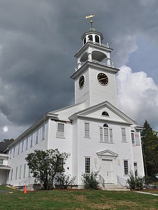
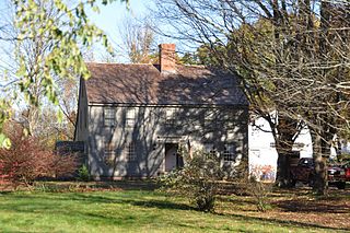
The Baptist New Meeting House is a historic church building at 461 Main Street in New London, New Hampshire. Built in 1826, its styling closely follows the patterns laid out by Asher Benjamin in his 1797 The Country Builder's Assistant, a major architectural guide from the Federal period. It was listed on the National Register of Historic Places in December 2005 and the New Hampshire State Register of Historic Places in April 2005.

St. John's Church is a historic church at 101 Chapel Street in Portsmouth, New Hampshire, United States. The brick building was designed by Alexander Parris and built in 1807; it was the first brick church in the state of New Hampshire, and is a rare surviving early design by Parris. The building was listed on the National Register of Historic Places in 1978. The church is home to an Episcopal congregation organized in 1732, with roots in the city's 17th-century founding.

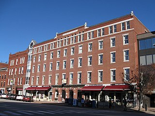
The Endicott Hotel is a historic hotel building at 1-3 South Main Street in Concord, New Hampshire. Completed in 1894, it is the only known surviving work in the state of the regionally prominent Damon Brothers architects, and it was the first major commercial building on South Main Street. It was listed on the National Register of Historic Places in 1987.
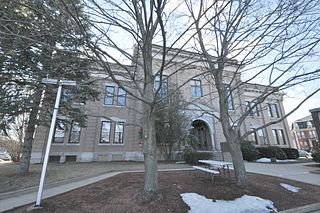
The former Merrimack County Courthouse stands at 163 North Main Street in Concord, New Hampshire, the state capital and county seat of Merrimack County. The oldest part of the courthouse building is a brick and granite two story structure, completed in 1857 to serve as a town hall and court building. The city and county used the building for town offices and county courts until 1904, when the city sold its interest in the building to the county. Between 1905 and 1907 the building was extensively remodeled to plans by local architect George S. Forrest. The courthouse has been listed on the National Register of Historic Places since 1979. As of 2018, a new courthouse had been constructed to the rear of the building, and county offices were to be moved into the original building.
The Morrill-Lassonde House is a historic house at 150 King Street in Boscawen, New Hampshire. Built about 1769, it is believed to be the oldest surviving house in the town. Historically significant residents include clock mechanism inventor Benjamin Morrill and artist Omer T. Lassonde, a founder of the New Hampshire Art Association. The house was listed on the National Register of Historic Places in 1984. Given by Lassonde's widow to the New Hampshire Art Association, it is now in private ownership.

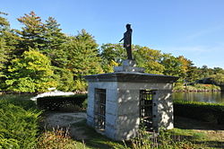
Stark Park is a city park located on the north side of Manchester, New Hampshire. It is a 30-acre (12 ha) parcel of land between River Road and the Merrimack River, which was once part of the larger farm property of American Revolutionary War hero John Stark. It was listed on the U.S. National Register of Historic Places in 2006, and the New Hampshire State Register of Historic Places in 2010.

Aquadoctan was one of the largest known Native American villages in what is now the U.S. state of New Hampshire. In an area commonly known today as The Weirs, the village lay on the north bank of the Winnipesaukee River at the outlet of Lake Winnipesaukee in the Lakes Region of New Hampshire. The site is now in Weirs Beach, a summer resort and village of the city of Laconia. The Native American village, whose archaeological remains extend for a half mile along the river and a quarter mile along the lake, has been documented through archaeological investigation to have evidence of settlement from 9,000 BCE to the late seventeenth century. Colonial reports document that the site was abandoned substantially in 1696, when most of New Hampshire's remaining native population withdrew to join the Pequawket at present-day Fryeburg, Maine.

The Lochmere Archeological District is a large archeological area on the banks of the Winnipesaukee River in Belknap County, New Hampshire, near the village of Lochmere. The area, part of which is now preserved by the state as the Brennick Lochmere Archaeological Site, is a multi-component site with evidence of human occupation from the Middle Archaic through the Late Woodland periods. The site was occupied in historic times by the Winnipesaukee sub-tribe of the Pennacook people, and is near Aquadoctan, one of the largest native towns of prehistoric New Hampshire.