
The Bald Knob National Wildlife Refuge is a 15,022 acres (60.79 km2) (2014) wildlife refuge located in White County, Arkansas about two miles south of the town of Bald Knob. The refuge is managed by the United States Fish and Wildlife Service. The refuge features large numbers of migratory waterfowl and bald eagles during the winter months.

The Alaska Peninsula National Wildlife Refuge is a United States National Wildlife Refuge in southwestern Alaska whose use is regulated as an ecological-protection measure. It stretches along the southern coast of the Alaska Peninsula, between the Becharof National Wildlife Refuge on its east and the end of the peninsula at False Pass in the west. In between, however, it is broken into sections by lands of the Aniakchak National Monument and Izembek National Wildlife Refuge. The refuge is administered from offices in King Salmon, Alaska and was established to conserve Alaska Peninsula brown bears, caribou, moose, marine mammals, shorebirds, other migratory birds and fish, and to comply with treaty obligations.
Montezuma National Wildlife Refuge is a wildlife preserve operated by the United States Fish and Wildlife Service, encompassing part of the Montezuma Swamp at the north end of Cayuga Lake. The 10,004-acre (40.48 km2) preserve is composed of swamps, pools and channels and is a stopping point for migratory birds. It is the largest contiguous wetland complex in the northeastern United States and comprises a portion of the larger Montezuma Wetlands Complex, which is a partnership between the USFWS, the New York State Department of Environmental Conservation, as well as several other non-profit support organizations.

Missisquoi National Wildlife Refuge is a National Wildlife Refuge in the U.S. state of Vermont located on the eastern shore of Lake Champlain and the southern side of Missisquoi Bay. The refuge is in Franklin County in the northwest corner of the state near the International Boundary with Canada.

The Klamath Basin National Wildlife Refuge Complex is a wildlife preserve operated by the United States Fish and Wildlife Service in the Klamath Basin of southern Oregon and northern California near Klamath Falls, Oregon. It consists of Bear Valley, Klamath Marsh and Upper Klamath National Wildlife Refuge (NWR) in southern Oregon and Lower Klamath, Tule Lake, and Clear Lake NWR in northern California.

The Erie National Wildlife Refuge is an 8,777-acre (3,552 ha) National Wildlife Refuge located in Crawford County, Pennsylvania. Named after the Erie tribe, it was established to provide waterfowl and other migratory birds with nesting, feeding, brooding, and resting habitat.

The Atlantic Flyway is a major north-south flyway for migratory birds in North America. The route generally starts in Greenland, then follows the Atlantic coast of Canada, then south down the Atlantic Coast of the United States to the tropical areas of South America and the Caribbean. Every year, migratory birds travel up and down this route following food sources, heading to breeding grounds, or traveling to overwintering sites.

Baskett Slough National Wildlife Refuge is in northwestern Oregon, 10 miles (16 km) west of Salem in Polk County. The Refuge consists of 1,173 acres (4.75 km2) of cropland, which provide forage for wintering geese, 300 acres (1.2 km2) of forests, 550 acres (2.2 km2) of grasslands, and 500 acres (2.0 km2) of shallow water seasonal wetlands and 35 acres (0.14 km2) of permanent open water. In 1965, Baskett Slough National Wildlife Refuge was created to help ensure some of the original habitat remained for species preservation. The refuge is managed by the U.S. Fish and Wildlife Service, an agency of the U.S. Department of the Interior.
The Rydell National Wildlife Refuge is an 2,120-acre (9 km2) National Wildlife Refuge in northwestern Minnesota, located in Woodside Township, Polk County, just west of Erskine in northwestern Minnesota. It was established in 1992, and receives more than 7,800 visitors each year. The refuge is a combination of maple/basswood/oak forest, wetlands, tallgrass prairie and bogs.

The Rachel Carson National Wildlife Refuge is a 9,125-acre (37 km2) National Wildlife Refuge made up of several parcels of land along 50 miles (80 km) of Maine's southern coast. Created in 1966, it is named for environmentalist and author Rachel Carson, whose book Silent Spring raised public awareness of the effects of DDT on migratory songbirds, and of other environmental issues.
Lake Ophelia National Wildlife Refuge was established in 1988 to protect the Mississippi/Red River floodplain ecosystem. The refuge is located in Avoyelles Parish, Louisiana, east central Louisiana. The refuge is named for its most prominent water body, the 350-acre (1.4 km2) Lake Ophelia that was at one time a channel of the nearby Red River of the South.
Upper Ouachita National Wildlife Refuge was established in 1978 and is located in Union and Morehouse Parishes in northern Louisiana.
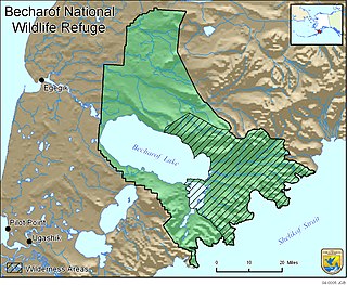
Becharof National Wildlife Refuge is a National Wildlife Refuge in the Aleutian Range of the Alaska Peninsula of southwestern Alaska. It is adjacent to Katmai National Park and Preserve. This national wildlife refuge, which covers an area of 1,200,000 acres (4,900 km2), was established in 1980 to conserve major brown bears, salmon, migratory birds, caribou, marine birds, and mammals and to comply with treaty obligations. It lies primarily in the east-central part of Lake and Peninsula Borough, but extends eastward into the mainland portion of Kodiak Island Borough. The refuge is administered from offices in King Salmon.
Aroostook National Wildlife Refuge is located on part of the former Loring Air Force Base, in Aroostook County, Maine. It was established in 1998, when 4,700 acres (19 km2) were transferred from the United States Air Force to the United States Fish and Wildlife Service. This refuge also administers some 2,400 acres (970 ha) of wetland conservation easements throughout Aroostook County. It is close to the Aroostook State Park where visitors can camp, hike, fish, and cross-country ski. In a portion of Maine where the landscape is dominated by agricultural crops such as potatoes and broccoli, Aroostook National Wildlife Refuge protects valuable wildlife habitat. The variety of habitat types attracts a diversity of wildlife species.
Maine Coastal Islands National Wildlife Refuge contains more than 50 offshore islands and four coastal parcels, totaling more than 8,100 acres. The complex spans more than 250 miles (400 km) of Maine coastline and includes five national wildlife refuges—Petit Manan, Cross Island, Franklin Island, Seal Island, and Pond Island. The U.S. Fish and Wildlife Service manages the refuge complex as part of the National Wildlife Refuge System.
Moosehorn National Wildlife Refuge is one of the northernmost National Wildlife Refuges in the Atlantic Flyway, a migratory route that follows the eastern coast of North America. The refuge provides important feeding and nesting habitat for many bird species, including waterfowl, wading birds, shorebirds, upland game birds, songbirds, and birds of prey.
Great Bay National Wildlife Refuge was established in 1992 and is located along the eastern shore of New Hampshire's Great Bay in the town of Newington. The area was formerly part of a weapons storage area at Pease Air Force Base, which was closed in 1991. A variety of rich wildlife habitats from uplands to open waters can be found throughout the refuge.

The Supawna Meadows National Wildlife Refuge is a component of the Delaware River estuary in Salem County, New Jersey, it is just north of the Salem River and south of Pennsville.

Hagerman National Wildlife Refuge (HNWR), a haven for migratory birds and other wildlife, lies in northwestern Grayson County, Texas, on the Big Mineral Arm of Lake Texoma, on the Red River between Oklahoma and Texas. This National Wildlife Refuge is made up of water, marsh, and upland habitat. Visitors can hike, observe wildlife, hunt, and fish throughout the year.

The Summer Lake Wildlife Area is a 29.6-square-mile (77 km2) wildlife refuge located on the northwestern edge of the Great Basin drainage in south-central Oregon. It is administered by the Oregon Department of Fish and Wildlife. The refuge is an important stop for waterfowl traveling along the Pacific Flyway during their spring and fall migrations. The Summer Lake Wildlife Area also provides habitat for shorebirds and other bird species as well as wide variety of mammals and several fish species. The Ana River supplies the water for the refuge wetlands.

