Related Research Articles

New Hampshire is a state in the New England region of the United States. It is bordered by Massachusetts to the south, Vermont to the west, Maine and the Gulf of Maine to the east, and the Canadian province of Quebec to the north. Of the 50 U.S. states, New Hampshire is the fifth smallest by area and the tenth least populous, with slightly more than 1.3 million residents. Concord is the state capital, while Manchester is the largest city. New Hampshire's motto, "Live Free or Die", reflects its role in the American Revolutionary War; its nickname, "The Granite State", refers to its extensive granite formations and quarries. It is best known nationwide for holding the first primary in the U.S. presidential election cycle.

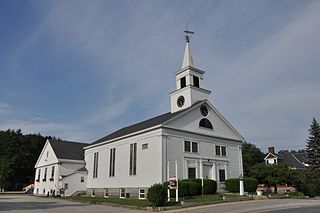
New Hampton is a town in Belknap County, New Hampshire, United States. The population was 2,377 at the 2020 census. A winter sports resort area, New Hampton is home to George Duncan State Forest and to the New Hampton School, a private preparatory school established in 1821.
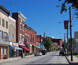
Berlin is a city along the Androscoggin River in Coös County in northern New Hampshire, United States. It is the northernmost city in New Hampshire. The population was 9,425 at the 2020 census, down from 10,051 at the 2010 census.
Pelham is a town in Hillsborough County, New Hampshire, United States. The population was 14,222 at the 2020 census, up from 12,897 at the 2010 census.
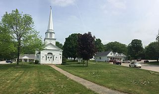
Canterbury is a town in Merrimack County, New Hampshire, United States. The population was 2,389 at the 2020 census. The Canterbury Shaker Village is in the eastern part of the town.

Franklin is a city in Merrimack County, New Hampshire, United States. At the 2020 census, the population was 8,741, the least of New Hampshire's 13 cities. Franklin includes the village of West Franklin.

The White Mountains Region is a tourism region designated by the New Hampshire Division of Travel and Tourism. It is located in northern New Hampshire in the United States and is named for the White Mountains, which cover most of the region. The southern boundary of the region begins at Piermont on the west, and runs east to Campton, then on to Conway and the Maine border. The northern boundary begins at Littleton and runs east to Gorham and the Maine border. The region to the north is known as the Great North Woods Region, which should not be confused with the larger and more general Great North Woods.
The Saco River is a river in northeastern New Hampshire and southwestern Maine in the United States. It drains a rural area of 1,703 square miles (4,410 km2) of forests and farmlands west and southwest of Portland, emptying into the Atlantic Ocean at Saco Bay, 136 miles (219 km) from its source. It supplies drinking water to roughly 250,000 people in thirty-five towns; and historically provided transportation and water power encouraging development of the cities of Biddeford and Saco and the towns of Fryeburg and Hiram. The name "Saco" comes from the Eastern Abenaki word [sɑkohki], meaning "land where the river comes out". The Jesuit Relations, ethnographic documents from the 17th century, refer to the river as Chouacoet.
The Great North Woods Region, also known as the North Country, is located at the northern tip of New Hampshire, United States, north of the White Mountains Region and is part of the larger Great North Woods. The Great North Woods is a tourism region of New Hampshire and is located in Coos County. The dividing line is loosely defined as running from Cushman, a hamlet within Dalton, to south of Berlin and east to the Maine border, roughly following US Route 2.

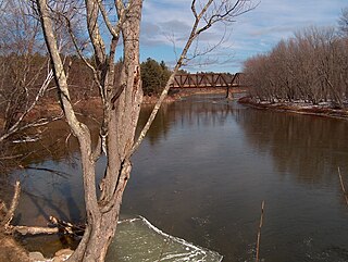
The Androscoggin River is a river in the U.S. states of Maine and New Hampshire, in northern New England. It is 178 miles (286 km) long and joins the Kennebec River at Merrymeeting Bay in Maine before its water empties into the Gulf of Maine on the Atlantic Ocean. Its drainage basin is 3,530 square miles (9,100 km2) in area. The name "Androscoggin" comes from the Eastern Abenaki term /aləssíkɑntəkw/ or /alsíkɑntəkw/, meaning "river of cliff rock shelters" ; or perhaps from Penobscot /aləsstkɑtəkʷ/, meaning "river of rock shelters". The Anglicization of the Abenaki term is likely an analogical contamination with the colonial governor Edmund Andros.
Nash Stream is a 15.3-mile-long (24.6 km) river in northern New Hampshire in the United States. It is a tributary of the Upper Ammonoosuc River and part of the Connecticut River watershed.
The Northern Forest Canoe Trail (NFCT) is a 740-mile (1,190 km) marked canoeing trail in the northeastern United States and Canada, extending from Old Forge in the Adirondacks of New York to Fort Kent, Maine. Along the way, the trail also passes through the states and provinces of Vermont, Quebec, and New Hampshire. The trail was opened on June 3, 2006.

Upton-Morgan State Forest is a 21-acre (8.5 ha) state forest in Concord, New Hampshire. It has a short interpretive trail.
Devils Slide State Forest is a 290-acre (120 ha) state forest in Stark, New Hampshire. It is part of a contiguous area of more than 2,000 acres (810 ha) of protected lands that includes the Kauffmann Forest and Percy State Forest.
Kauffmann Forest is a protected area around Christine Lake in Coos County, New Hampshire. It is owned by the Percy Summer Club and is protected by a conservation easement held by the Society for the Protection of New Hampshire Forests.
Mount Mitten is a 3,058 foot peak in the Dartmouth Range in New Hampshire. It is named for a mitten that Timothy Nash lost when climbing a tree atop the mountain to get his bearings. He saw Crawford Notch.
Mascoma State Forest is an area of forested land in Canaan in Grafton County, New Hampshire, on the west side of the Mascoma River. As of 2007, the tract covers 216 acres (87 ha). The forest borders the 900-acre Bear Pond Natural Area. Mascoma State Forest is managed by the state of New Hampshire Division of Forests and Lands.
References
- ↑ "State Owned Lands: Forests in Alphabetical Order" (PDF). NH Division of Forests and Lands. Retrieved March 7, 2018.
- ↑ "Nash Stream Forest". NH Division of Forests and Lands. Retrieved March 7, 2018.
Coordinates: 44°40′51″N71°26′16″W / 44.68083°N 71.43778°W