List of New Hampshire state parks

Last updated

USA New Hampshire location map.svg
Green pog.svg
Green pog.svg
Green pog.svg
Green pog.svg
Green pog.svg
Green pog.svg
Green pog.svg
Green pog.svg
Green pog.svg
Green pog.svg
Green pog.svg
Green pog.svg
Green pog.svg
Green pog.svg
Green pog.svg
Green pog.svg
Green pog.svg
Green pog.svg
Green pog.svg
Green pog.svg
Green pog.svg
Green pog.svg
Green pog.svg
Green pog.svg
Green pog.svg
Green pog.svg
Green pog.svg
Green pog.svg
Green pog.svg
Green pog.svg
Green pog.svg
Green pog.svg
Green pog.svg
Green pog.svg
Green pog.svg
Green pog.svg
Green pog.svg
Green pog.svg
Green pog.svg
Green pog.svg
Green pog.svg
Green pog.svg
Green pog.svg
Green pog.svg
Green pog.svg
Green pog.svg
Green pog.svg
Green pog.svg
Green pog.svg
Green pog.svg
Green pog.svg
Green pog.svg
Green pog.svg
Green pog.svg
Green pog.svg
Green pog.svg
Green pog.svg
Green pog.svg
Green pog.svg
Green pog.svg
Green pog.svg
Green pog.svg
Green pog.svg
Green pog.svg
Green pog.svg
Map of New Hampshire state parks

This is a list of New Hampshire state parks. State parks in the U.S. state of New Hampshire are overseen by the New Hampshire Division of Parks and Recreation. [1] [2]

Contents

New Hampshire State Parks logo.png

New Hampshire state parks

Name [3] [4] CountyTownSizeEstab-
lished
Image
Ahern State Park Belknap Laconia 128 acres (52 ha)1994 Ahern Winnisquam 2008.jpg
Androscoggin Wayside Park Coös Errol 1 acre (0.40 ha)1958 ErrolNH AndroscogginWaysidePark2.jpg
Bear Brook State Park Merrimack Allenstown 10,083 acres (4,080 ha)1943 Bear Brook State Park - Beaver Pond.JPG
Beaver Brook Falls Wayside Coös Colebrook 7.3 acres (3.0 ha) BeaverBrookFallsWaysidePark4.jpg
Cardigan Mountain State Park Grafton Orange 5,655 acres (2,288 ha)1939 Cardigan State Park, 30 May 2009, no. 16.jpg
Chesterfield Gorge Natural Area Cheshire Chesterfield 13 acres (5.3 ha)1948 Chesterfield Gorge, Chesterfield NH.jpg
Clough State Park Hillsborough Weare 1964 Clough State Park, Weare NH.jpg
Coleman State Park Coös Stewartstown 1,573 acres (637 ha)1956 Coleman State Park.jpg
Crawford Notch State Park Carroll Hart's Location 5,775 acres (2,337 ha)1913 CrawfordNotchCenter.jpg
Deer Mountain Campground Coös Pittsburg
Dixville Notch State Park Coös Dixville 127 acres (51 ha) Dixville Notch SP.JPG
Echo Lake State Park Carroll Conway 118 acres (48 ha) Echo Lake, North Conway, NH.jpg
Eisenhower Memorial Wayside Park Coös Crawford's Purchase 7 acres (2.8 ha)1979 Eisenhower Memorial Wayside View June 2019.jpg
Ellacoya State Park Belknap Gilford 82 acres (33 ha)1956 Ellacoya State Park.jpg
Forest Lake State Park Coös Dalton 397 acres (161 ha)1935 Forest Lake NH Sept 2020.jpg
Franconia Notch State Park Grafton Franconia 6,692.8 acres (2,708.5 ha)1928 Echo Lake in Fall of 2008.JPG
Gardner Memorial Wayside Park Sullivan Springfield 1980 Gardner Memorial Wilmot NH.jpg
Greenfield State Park Hillsborough Greenfield 400 acres (160 ha) GreenfieldStatePark OtterLakeInWinter.jpg
Hampton Beach State Park Rockingham Hampton 50 acres (20 ha)1933 Hampton Beach, New Hampshire 2004.jpg
Jenness State Beach Rockingham Rye 1.3 acres (0.53 ha)1980 Jenness Beach Rye NH March 2019.jpg
Jericho Mountain State Park Coös Berlin 7,430 acres (3,010 ha)2005 JericoLake.JPG
Kingston State Park Rockingham Kingston 44 acres (18 ha) Kingston State Park, Kingston NH.jpg
Lake Francis State Park Coös Pittsburg 38 acres (15 ha)1976
Lake Tarleton State Park Grafton Piermont 48 acres (19 ha) Lake Tarleton State Park July 2020.jpg
Madison Boulder Natural Area Carroll Madison 17 acres (6.9 ha)1946 Boulder, Madison, NH.jpg
Milan Hill State Park Coös Milan 102 acres (41 ha)1939
Miller State Park Hillsborough Peterborough 533 acres (216 ha)1891 Pack Monadnock.jpg
Mollidgewock State Park Coös Errol 46 acres (19 ha)1972 ErrolNH MollidgewockSP 2.jpg
Monadnock State Park Cheshire Jaffrey 1,017 acres (412 ha) Mount Monadnock from route 124.JPG
Moose Brook State Park Coös Gorham 755 acres (306 ha)1936 Moose Brook State Park (2605354825).jpg
Mount Sunapee State Park Merrimack Newbury 2,893 acres (1,171 ha)1948 MountSunapeefromLake.jpg
Mount Washington State Park Coös Sargent's Purchase 60.3 acres (24.4 ha)1964 2016-09-03 14 09 34 View east-southeast across the summit of Mount Washington in Sargent's Purchase Township, Coos County, New Hampshire.jpg
Nansen Wayside Park Coös Milan 14 acres (5.7 ha) MilanNH NansenWaysidePark2.jpg
North Hampton State Beach Rockingham North Hampton 1.1 acres (0.45 ha)1980 NorthHamptonNH NorthHamptonStateBeach2.jpg
Northwood Meadows State Park Rockingham Northwood 674.5 acres (273.0 ha)1990
Odiorne Point State Park Rockingham Rye 333.7 acres (135.0 ha)1961 Odiorne Seacoast Science Center March 2019.jpg
Pawtuckaway State Park Rockingham Nottingham 5,536.1 acres (2,240.4 ha) Pawtuckaway Lake.JPG
Pillsbury State Park Sullivan Washington 4,456 acres (1,803 ha) Pillsbury State Park.jpg
Pisgah State Park Cheshire Chesterfield 13,361 acres (5,407 ha)1967
Rhododendron State Park Cheshire Fitzwilliam 2,723 acres (1,102 ha)1947 FitzwilliamNH OldPatchPlace.jpg
Rollins State Park Merrimack Warner 118.5 acres (48.0 ha)1950 Rollins Trail Mount Kearsarge NH Oct 2020.jpg
Rye Harbor State Park Rockingham Rye 63 acres (25 ha)1936 RyeNH RyeHarborSP marsh view 2.jpg
Sculptured Rocks Natural Area Grafton Groton 272 acres (110 ha) SculpRocks.jpg
Silver Lake State Park Hillsborough Hollis 80 acres (32 ha)1954 Silver Lake State Park, Hollis NH.jpg
Umbagog Lake State Park Coös Errol 136.0 acres (55.0 ha)1998 Umbagog Lake NH.jpg
Wadleigh State Park Merrimack Sutton 43 acres (17 ha)1934
Wallis Sands State Beach Rockingham Rye 30 acres (12 ha)1964 Wallis Sands State Park, Rye NH.jpg
Weeks State Park Coös Lancaster 420 acres (170 ha)1941 WeeksStatePark TowerView1.jpg
Wellington State Park Grafton Alexandria 204 acres (83 ha)1931 Newfound Lake Sept 2005.jpg
Wentworth State Park Carroll Wolfeboro 50 acres (20 ha)1934
White Lake State Park Carroll Tamworth 902.7 acres (365.3 ha)1933
Winslow State Park Merrimack Wilmot 1935 Mount Kearsarge from The Bulkhead.jpg

State historic sites

Name [5] CountyTownSizeEstab-
lished
Image
Bedell Bridge State Historic Site Grafton Haverhill 38 acres (15 ha) 226 08 Bedell Covered Bridge.jpg
Daniel Webster Birthplace State Historic Site Merrimack Franklin 147 acres (59 ha) FranklinNH DanielWebsterBirthplace.jpg
Endicott Rock State Historic Site Belknap Laconia 0.1 acres (0.040 ha) EndicottRock 3.jpg
Fort Constitution State Historic Site Rockingham New Castle 2 acres (0.81 ha) FortConstitution 6.jpg
Fort Stark State Historic Site Rockingham New Castle 10 acres (4.0 ha) FortStark a small battery.jpg
Franklin Pierce Homestead State Historic Site Hillsborough Hillsborough 13 acres (5.3 ha) HillsboroughNH FranklinPierceHomestead.jpg
Governor Wentworth Historic Site Carroll Wolfeboro 96 acres (39 ha) Governor Wentworth Historic Site.jpg
Hannah Duston Memorial State Historic Site Merrimack Boscawen Hannahdustin statue.JPG
John Wingate Weeks Historic Site Coös Lancaster 420 acres (170 ha)1941 WeeksStatePark CarriageHouse.jpg
Nansen Ski Jump State Historic Site Coös Milan 14 acres (5.7 ha) Nansen Ski Jump, Berlin, N.H.jpg
Robert Frost Farm State Historic Site Rockingham Derry Robertfrostfarm.JPG
Taylor Mill State Historic Site Rockingham Derry Taylor Mill2.jpg
Tip-Top House Coös Sargent's Purchase Tip-Top House 5.JPG
Wentworth–Coolidge Mansion State Historic Site Rockingham Portsmouth PortsmouthNH WentworthCoolidgeMansion 2.jpg
White Island State Historic Site Rockingham Rye 5 acres (2.0 ha) Lighthouse on the Rock.jpg
Willey House Carroll Hart's Location Willey House, Crawford Notch, White Mountains, New Hampshire.png

Other state protected areas

Other areas of note still owned by the state but not maintained.

Name [4] CountyTownSizeEstab-
lished
Image
Bear's Den Natural Area Cheshire Gilsum 95 acres (38 ha) [6] [7]
Binney Pond Natural Area Hillsborough New Ipswich 99 acres (40 ha) [8]
Bradford Pines Natural Area Merrimack Bradford 5 acres (2.0 ha) [9]
Crosby Mountain State Park Grafton Groton 86 acres (35 ha) [10] Donated in 1971
Curtiss Dogwood Natural Area Hillsborough Wilton 14 acres (5.7 ha)
Dublin Lake Scenic Area Cheshire Dublin 1.3 acres (0.53 ha) DublinPond.jpg
Heath Pond Bog Natural Area Carroll Ossipee 1,378.5 acres (557.9 ha) [11] [12]
Humphrey's Ledge Natural Area Carroll Bartlett 36 acres (15 ha) [13]
Jeremy Mill Natural Area Hillsborough Pelham 63 acres (25 ha) [14] [15]
Mascot Mine Natural Area Coös Gorham 11.7 acres (4.7 ha) [16]
Ossipee Lake Natural Area Carroll Ossipee 400 acres (160 ha) [17]
Otter Brook Lake Cheshire Keene 2.5 acres (1.0 ha)
Smith's Ferry Heritage Park Hillsborough Manchester 17 acres (6.9 ha) [18]
Urban Forestry Center Rockingham Portsmouth 182 acres (74 ha) [19] Urban Forestry Center (arboretum), Portsmouth, NH - IMG 8236.JPG
Wantastiquet Mountain Natural Area or Wantastiquet State Forest Cheshire West Chesterfield 1,006 acres (407 ha) [20] [21]

See also

Related Research Articles

Tamworth, New Hampshire Town in New Hampshire, United States

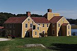
Tamworth is a town in Carroll County, New Hampshire, United States. The population was 2,812 at the 2020 census. Tamworth includes the villages of Chocorua, South Tamworth, Wonalancet, and Whittier. The White Mountain National Forest is to the north. The town is home to Hemenway State Forest in the north and White Lake State Park in the southeast.

Miller State Park State park in Hillsborough County, New Hampshire

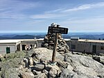
Miller State Park is the oldest state-run park in New Hampshire, a state in the New England region of the United States. It is located in the towns of Peterborough and Temple, and is centered on Pack Monadnock, a 2,290-foot (700 m) mountain.

Lakes Region (New Hampshire) Region in New Hampshire, United States

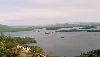
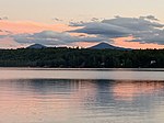
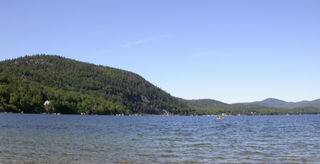
The Lakes Region of New Hampshire is located in the east-central part of the state, south of the White Mountains Region and extending to the Maine border. It is named for the numerous lakes in the region, the largest of which are Lake Winnipesaukee, Lake Winnisquam, Squam Lake, and Newfound Lake. The area comprises all of Belknap County, the southern portion of Carroll County, the eastern portion of Grafton County, and the northern portions of Strafford County and Merrimack County. The largest municipality is the city of Laconia.

Rollins State Park State park in Merrimack County, New Hampshire

Rollins State Park is a public recreation area on the southern slope of Mount Kearsarge in Warner, New Hampshire. The state park is at the entrance to an auto road that ascends to within 0.5 miles (0.8 km) of the summit. Picnic facilities are available, and hiking trails leave from the high point of the auto road to the summit. The park is named for Frank W. Rollins, who served as governor of New Hampshire from 1899 to 1901.

Pine River (New Hampshire) River in New Hampshire, United States

The Pine River is a 19.2-mile-long (30.9 km) river located in eastern New Hampshire in the United States. It is a tributary of Ossipee Lake, part of the Saco River watershed leading to the Atlantic Ocean.

Jericho Mountain State Park State park in New Hampshire, United States

Jericho Mountain State Park is located in the White Mountains in Berlin, New Hampshire, United States. The park offers trail riding for ATV, UTV, trail bike, and snowmobile enthusiasts, as well as camping, swimming, fishing, canoeing, and picnicking at Jericho Lake.

Monadnock-Sunapee Greenway

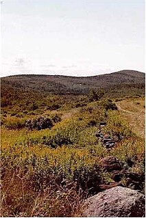
The Monadnock-Sunapee Greenway (MSG) is a 50-mile (80 km) hiking trail that traverses the highlands of southern New Hampshire from Mount Monadnock in Jaffrey to Mount Sunapee in Newbury. Located approximately 27 miles (43 km) from the city of Concord, New Hampshire, the trail traverses a rural, heavily glaciated and metamorphic upland studded with lakes, heath barrens, the rocky summits of several monadnocks, and dense woodland of the northern hardwood forest type. The trail is maintained primarily through the efforts of the Monadnock-Sunapee Greenway Trail Club.

Bear Brook State Park State park in Merrimack County, New Hampshire

Bear Brook State Park is a 10,000-acre (4,000 ha) preserve in Allenstown, New Hampshire, and neighboring towns. It is one of New Hampshire's largest state parks.

Pisgah State Park is a 13,300-acre (5,400 ha) public recreation area located in the Cheshire County towns of Winchester, Chesterfield and Hinsdale in New Hampshire. It is the largest state park in New Hampshire and contains a complete watershed north of the Ashuelot River, seven ponds, four highland ridges, numerous wetlands, and a 20-acre (8 ha) parcel of old-growth forest.

New Hampshire Division of Parks and Recreation Government agency in the U.S. state of New Hampshire

The New Hampshire Division of Parks and Recreation is responsible for the management of state parks within New Hampshire, the Cannon Mountain Ski Area, the Bureau of Trails, the Bureau of Historic Sites, and various community programs. Philip A. Bryce is director of the division. Since 2017, the division's parent agency has been the New Hampshire Department of Natural and Cultural Resources (DNCR).

Pawtuckaway State Park

Pawtuckaway State Park is a 5,000-acre (20 km2) preserve in New Hampshire, United States. It is one of the largest state parks in southeastern New Hampshire and is named for Pawtuckaway Lake and the Pawtuckaway Mountains. The park extends from the west shore of the lake to the west side of the mountains.

Groton State Forest State Forest in Caledonia, Orange, and Washington counties, Vermont

Groton State Forest covers 26,164 acres (105.88 km2) in Danville, Groton, Marshfield, Orange, Peacham, Plainfield, Topsham, Vermont. The forest covers areas in Caledonia, Orange, and Washington Counties. Major roads through the forest are U.S. Route 302 and Vermont Route 232.

Winslow State Park State park in Merrimack County, New Hampshire

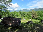
Winslow State Park is a public recreation area located on the northwest slope of Mount Kearsarge in Wilmot, New Hampshire. The state park features a picnic area on an 1,820-foot (550 m) plateau with views of the White Mountains to the north. A 1.1-mile (1.8 km) foot trail leads from the picnic area to the summit of Mount Kearsarge. A 1.7-mile (2.7 km) trail offers a loop possibility.

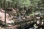
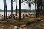
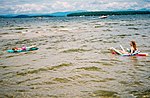
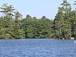
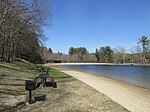
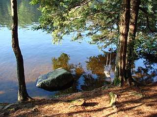
White Lake State Park is a 902.7-acre (365.3 ha) public recreation area in Tamworth, New Hampshire. The state park surrounds 125-acre (51 ha) White Lake, a typical glacial lake. It is open year-round and offers swimming, hiking, non-motorized boating, picnicking, trout fishing, winter sports, day-use area, group areas, and seasonal camping.

Wellington State Park State park in Grafton County, New Hampshire

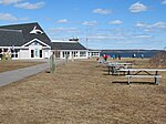
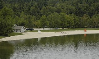
Wellington State Park is a 220-acre (89 ha) public recreation area located on the southwest shore of Newfound Lake in Bristol, New Hampshire. The state park features the largest freshwater swimming beach in the New Hampshire state park system. Activities include swimming, fishing, non-motorized boating, hiking and picnicking. A 7-mile (11 km) trail system that begins in the park leads hikers to the top of Little and Big Sugarloaf mountains.

Greenfield State Park State park in New Hampshire, United States

Greenfield State Park is a 400-acre (160 ha) public recreation area in Greenfield, New Hampshire. The state park features ponds, bogs, and a forest that extends to the shore of undeveloped Otter Lake. Activities include camping, hiking, swimming, fishing, picnicking, and non-motorized boating. There is a small store, playground, boat ramp, and rentals.

Wadleigh State Park is a public recreation area located on the south shore of 170-acre (69 ha) Kezar Lake in Sutton, New Hampshire. The state park has a bathhouse and playing fields and offers opportunities for swimming, picnicking, fishing, and boating.

Echo Lake State Park State park in Carroll County, New Hampshire

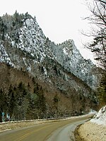
Echo Lake State Park is a public recreation area in North Conway, New Hampshire, that features 15.7-acre (6.4 ha) Echo Lake and two rock ledges with scenic views, Cathedral Ledge and White Horse Ledge. Activities include swimming, hiking, non-motorized boating, picnicking and fishing. There is a one-mile trail around the lake.

Mount Sunapee State Park State park in Merrimack County, New Hampshire

Mount Sunapee State Park is a public recreation area in Newbury, New Hampshire. The state park's nearly 3,000 acres (1,200 ha) include most of Mount Sunapee and a beach area on Lake Sunapee. Park activities include swimming, hiking, camping, skiing, fishing, picnicking, and non-motorized boating. The park's ski area is operated as Mount Sunapee Resort under the management of Vail Resorts Inc.

References

  1. "Division". nhstateparks.org. New Hampshire Division of Parks and Recreation. Retrieved July 7, 2019.
  2. All data come from respective New Hampshire State Parks webpage unless otherwise noted.
  3. "State Parks". nhstateparks.org. New Hampshire Division of Parks and Recreation. Retrieved July 7, 2019.
  4. 1 2 "NH Forests, Parks, Natural Areas and Other" (PDF). NH Division of Forest and Lands. Archived from the original (PDF) on March 3, 2016. Retrieved 20 February 2017.
  5. "Historic Sites". nhstateparks.org. New Hampshire Division of Parks and Recreation. Retrieved October 10, 2020.
  6. "Bear Den Geological Park & Trail". Trails.com. Retrieved 18 February 2017.
  7. "Bear's Den Natural Area". NH Garden Solutions. Retrieved 18 February 2017.
  8. "Binney Pond Wildlife area access, Wapack Trail - New Ipswich, NH". Waymarking. Retrieved 18 February 2017.
  9. "Bradford, NH Trails and Public Lands Map" (PDF). Bradford, NH. Retrieved 20 February 2017.
  10. "Cockermouth Forest - Bald Knob & Mt. Crosby: 4/30/09". Mountain Wandering. Retrieved 20 February 2017.
  11. "Heath Pond Bog". NH Division of Forests and Lands. Retrieved 20 February 2017.
  12. "Heath Pond Bog Natural Area". Ossipee Lake Alliance. Retrieved 20 February 2017.
  13. "Humphrey's Ledge". Mountain Project. Retrieved 20 February 2017.
  14. "Fire Towers". Double-D Mountain Runner. May 7, 2014. Retrieved 20 February 2017.
  15. "Conservation Map 2008" (PDF). Town of Pelham, NH. Retrieved 20 February 2017.
  16. "Going "Batty" Trying to Avoid the Rain (Mascot Pond: 18-Jun-2009)". Views from the Top. Retrieved 20 February 2017.
  17. "Ossipee Lake Natural Area". Ossipee Lake Alliance. Retrieved 20 February 2017.
  18. "Greening the City Master Plan" (PDF). Manchester NH. p. 109. Retrieved 20 February 2017.
  19. "Urban Forestry Center". NH Division of Forests and Lands. Retrieved 20 February 2017.
  20. "Wantastiquet Natural Area Summit Trail". All Trails. Retrieved 18 February 2017.
  21. "Map". Chesterfield Outdoors. Retrieved 20 February 2017.