Sugar Hill, New Hampshire

Last updated

Sugar Hill, New Hampshire
Town
The Sunset Hill House, Sugar Hill, NH.jpg
The Sunset Hill House, Sugar Hill, c.1910
Grafton-Sugar-Hill-NH.png
Coordinates: 44°12′55″N71°47′58″W / 44.21528°N 71.79944°W / 44.21528; -71.79944
Country United States
State New Hampshire
County Grafton
Incorporated 1962
Government
   Select Board
  • Margaret Connors, Chair
  • Chris Ellms
  • Richard Bielefield
Area
[1]
  Total17.23 sq mi (44.63 km2)
  Land17.05 sq mi (44.16 km2)
  Water0.18 sq mi (0.47 km2)  1.06%
Elevation
1,325 ft (404 m)
Population
 (2020) [2]
  Total647
  Density38/sq mi (14.7/km2)
Time zone UTC-5 (Eastern)
  Summer (DST) UTC-4 (Eastern)
ZIP code
03586
Area code 603
FIPS code 33-74740
GNIS feature ID0873730
Website www.sugarhillnh.org

Sugar Hill is a town in Grafton County, New Hampshire, United States. The population was 647 at the 2020 census, [2] an increase over the figure of 563 tabulated in 2010. [3] The town overlooks the White Mountain National Forest, with views of the Presidential, Franconia, Kinsman and Dalton ranges. Sugar Hill was incorporated as a town in 1962, the most recent in New Hampshire.

Contents

History

Sugar Hill is known for its lupine blooms every June. Sugar Hill Lupine.jpg
Sugar Hill is known for its lupine blooms every June.

Incorporated in 1962 out of the town of Lisbon after considerable litigation, Sugar Hill is the most recently incorporated town in the state. The name "Sugar Hill" comes from the large groves of sugar maples within the town limits.

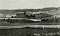
Offering clean air and panoramic views from atop Sunset Hill Ridge of both the White Mountains and Green Mountains, the community became a fashionable Victorian resort. First attracted by paintings of White Mountain artists, the wealthy arrived by train to escape the heat, humidity and pollution of summers in Boston, Hartford, New York and Philadelphia. Several hostelries were built, including the Hotel Lookoff. But the grandest was the Sunset Hill House, built in 1880 after rail service arrived in neighboring Lisbon Village (Sunset Hill Station). With the longest porch on a single side in New Hampshire, the Second Empire hotel accommodated 350 guests and 300 staff. Patrons found amusement in the casino and bowling alley, or on carriage rides touring nearby Franconia Notch. Built in 1897, the 9-hole Sugar Hill House Golf Course, together with its 1900 clubhouse, are the oldest in the state and are listed on the National Register of Historic Places. Bobby Jones played the links.

With the advent of automobiles came a decline in grand hotels, however, as tourists were no longer restricted by the limits of rail service. The Sunset Hill House remained open until 1973, longer than many of its type in the region. But it closed at season's end, when the furnishings were sold at auction. The aging structure was demolished in 1974, although its annex survived and was purchased in 2013 by new owners, to reopen in 2015 as "The Inn at Sunset Hill".

Otto Lang, ski instructor, on slope near Peckett's Inn - 1936 Otto Lang Peckett's 1936.jpg
Otto Lang, ski instructor, on slope near Peckett's Inn – 1936

Peckett's-on-Sugar Hill

Robert P. Peckett Sr. acquired land on Sugar Hill around 1900 and founded the Peckett's-on-Sugar Hill Inn. [4] While hosting winter guests early in the century, the need for increased clientele prompted him, with the assistance of his daughter, Katherine "Kate" Peckett, to establish the first resort-based ski school in the United States. [5] The first two ski instructors were German; they introduced the Arlberg technique developed by Hannes Schneider at St. Anton. In 1931, Sig Buchmayr joined the staff. Kate Peckett brought in several more European instructors including Otto Lang to teach the Arlberg system. Among pupils were Nelson Rockefeller, Averell Harriman, Lowell Thomas, Minot Dole and Roger Peabody. [6] Subsequent efforts by Kate, the CCC and others resulted in the development of the Taft Ski Trail and other facilities on the Cannon Mountain Ski Area. [7]

Geography

According to the United States Census Bureau, the town has a total area of 17.2 square miles (44.6 km2), of which 17.1 square miles (44.2 km2) are land and 0.2 square miles (0.5 km2) are water, comprising 1.06% of the town. [1] Sugar Hill is drained by the Gale River and other tributaries of the Ammonoosuc River, part of the Connecticut River watershed. The town is crossed by New Hampshire Route 117. Interstate 93 and New Hampshire Route 18 pass through the northeastern corner of the town. The highest point in Sugar Hill is the summit of Bronson Hill, at 2,078 feet (633 m) above sea level, in the southwestern corner of the town.

Demographics

Historical population
CensusPop.Note
1970 336
1980 39718.2%
1990 46416.9%
2000 56321.3%
2010 5630.0%
2020 64714.9%
U.S. Decennial Census [2] [8]
Sugar Hill Meetinghouse, listed on the New Hampshire State Register of Historic Places Sugar Hill Meetinghouse.JPG
Sugar Hill Meetinghouse, listed on the New Hampshire State Register of Historic Places

As of the census [9] of 2000, there were 563 people, 258 households, and 164 families residing in the town. The population density was 32.9 inhabitants per square mile (12.7/km2). There were 385 housing units at an average density of 22.5 per square mile (8.7/km2). The racial makeup of the town was 98.40% White, 1.24% Asian, and 0.36% from two or more races. Hispanic or Latino of any race were 0.18% of the population.

There were 258 households, out of which 22.1% had children under the age of 18 living with them, 56.2% were married couples living together, 4.7% had a female householder with no husband present, and 36.4% were non-families. 29.8% of all households were made up of individuals, and 12.0% had someone living alone who was 65 years of age or older. The average household size was 2.18 and the average family size was 2.72.

In the town, the population was spread out, with 18.1% under the age of 18, 5.3% from 18 to 24, 24.2% from 25 to 44, 33.7% from 45 to 64, and 18.7% who were 65 years of age or older. The median age was 46 years. For every 100 females, there were 98.9 males. For every 100 females age 18 and over, there were 101.3 males.

The median income for a household in the town was $49,219, and the median income for a family was $60,288. Males had a median income of $36,667 versus $25,714 for females. The per capita income for the town was $29,743. About 4.3% of families and 5.3% of the population were below the poverty line, including none of those under age 18 and 10.6% of those age 65 or over.

Notable people


Sites of interest

Related Research Articles

<span class="mw-page-title-main">Hanover, New Hampshire</span> Town in New Hampshire, United States

Hanover is a town located along the Connecticut River in Grafton County, New Hampshire, United States. As of the 2020 census, its population was 11,870. The town is home to the Ivy League university Dartmouth College, the U.S. Army Corps of Engineers Cold Regions Research and Engineering Laboratory, and Hanover High School. The Appalachian Trail crosses the town, connecting with a number of trails and nature preserves.

<span class="mw-page-title-main">Lincoln, New Hampshire</span> Town in New Hampshire, United States

Lincoln is a town in Grafton County, New Hampshire, United States. It is the second-largest town by area in New Hampshire. The population was 1,631 at the 2020 census. The town is home to the New Hampshire Highland Games and to a portion of Franconia Notch State Park. Set in the White Mountains, large portions of the town are within the White Mountain National Forest. The Appalachian Trail crosses the western and northeastern parts of the town. Lincoln is the location of Loon Mountain Ski Resort and associated recreation-centered development.

<span class="mw-page-title-main">Grafton County, New Hampshire</span> County in New Hampshire, United States

Grafton County is a county in the U.S. state of New Hampshire. As of the 2020 census, the population was 91,118. Its county seat is North Haverhill, a village within the town of Haverhill. Until 1972, the county courthouse and other offices were in downtown Woodsville, a larger village within the town of Haverhill.

<span class="mw-page-title-main">North Conway, New Hampshire</span> Census-designated place in New Hampshire, United States

North Conway is a census-designated place (CDP) and village in eastern Carroll County, New Hampshire, United States. The population was 2,116 at the 2020 census. A year-round resort area, North Conway is the second-largest village within the town of Conway, after the village of Conway proper. North Conway maintains its own fire station, post office and public library, sharing its other services with Conway. The White Mountain National Forest is to the west and north. The area is home to Cathedral Ledge, Echo Lake State Park, and Cranmore Mountain Resort. North Conway is known for its large number of outlet shops.

<span class="mw-page-title-main">Benton, New Hampshire</span> Town in New Hampshire, United States

Benton is a town in Grafton County, New Hampshire, United States. The population was 374 at the 2020 census. Located in the White Mountains, Benton is largely surrounded by the White Mountain National Forest. The town is crossed by the Appalachian Trail.

<span class="mw-page-title-main">Bridgewater, New Hampshire</span> Town in New Hampshire, United States

Bridgewater is a town in Grafton County, New Hampshire, United States. The population was 1,160 at the 2020 census.

<span class="mw-page-title-main">Campton, New Hampshire</span> Town in New Hampshire, United States

Campton is a town in Grafton County, New Hampshire, United States. The population was 3,343 at the 2020 census. Campton, which includes the villages of Blair, Campton Hollow, Lower Campton and West Campton, is home to Blair State Forest and Livermore Falls State Forest. It is located in the foothills of the White Mountains, and parts of the White Mountain National Forest are in the northeast and northwest.

<span class="mw-page-title-main">Easton, New Hampshire</span> Town in New Hampshire, United States

Easton is a town in Grafton County, New Hampshire, United States. The population was 292 at the 2020 census.

<span class="mw-page-title-main">Franconia, New Hampshire</span> Town in New Hampshire, United States

Franconia is a town in Grafton County, New Hampshire, United States. The population was 1,083 at the 2020 census. Set in the White Mountains, Franconia is home to the northern half of Franconia Notch State Park. Parts of the White Mountain National Forest are in the eastern and southern portions of the town. The Appalachian Trail crosses the town.

<span class="mw-page-title-main">Grafton, New Hampshire</span> Town in New Hampshire, United States

Grafton is a town in Grafton County, New Hampshire, United States. The population was 1,385 at the 2020 census.

<span class="mw-page-title-main">Hebron, New Hampshire</span> Town in New Hampshire, United States

Hebron is a town in Grafton County, New Hampshire, United States. The population was 632 at the 2020 census. Settlements include the town center and the village of East Hebron.

<span class="mw-page-title-main">Landaff, New Hampshire</span> Town in New Hampshire, United States

Landaff is a town in Grafton County, New Hampshire, United States. As of the 2020 census, the town population was 446.

<span class="mw-page-title-main">Lyman, New Hampshire</span> Town in New Hampshire, United States

Lyman is a town in Grafton County, New Hampshire, United States. The population was 585 at the 2020 census.

<span class="mw-page-title-main">Thornton, New Hampshire</span> Town in New Hampshire, United States

Thornton is a town in Grafton County, New Hampshire, United States. The population was 2,708 at the 2020 census, up from 2,490 at the 2010 census.

<span class="mw-page-title-main">Warren, New Hampshire</span> Town in New Hampshire, United States

Warren is a town in Grafton County, New Hampshire, United States. The population was 825 at the 2020 census, down from 904 at the 2010 census. Warren includes the village of Glencliff. The Appalachian Trail crosses the town in the west.

<span class="mw-page-title-main">Waterville Valley, New Hampshire</span> Town in New Hampshire, United States

Waterville Valley is a New England town in Grafton County, New Hampshire, United States. The population was 508 at the 2020 census, up from 247 at the 2010 census.

<span class="mw-page-title-main">Danbury, New Hampshire</span> Town in New Hampshire, United States

Danbury is a town in Merrimack County, New Hampshire, United States. The population was 1,250 at the 2020 census.

<span class="mw-page-title-main">Springfield, New Hampshire</span> Place in New Hampshire, United States

Springfield is a town in Sullivan County, New Hampshire, United States. The population was 1,259 at the 2020 census. Gile State Forest is located within the town.

<span class="mw-page-title-main">Lisbon, New Hampshire</span> Town in New Hampshire, United States

Lisbon is a town in Grafton County, New Hampshire, United States. The population was 1,621 at the 2020 census. Lisbon hosts an annual lilac festival on Memorial Day weekend.

Littleton is a census-designated place (CDP) and the main village in the town of Littleton in Grafton County, New Hampshire, United States. The population of the CDP was 4,467 at the 2020 census, out of 6,005 in the entire town.

References

  1. 1 2 "2021 U.S. Gazetteer Files – New Hampshire". United States Census Bureau. Retrieved November 30, 2021.
  2. 1 2 3 "Sugar Hill town, Grafton County, New Hampshire: 2020 DEC Redistricting Data (PL 94-171)". U.S. Census Bureau. Retrieved November 30, 2021.
  3. "Geographic Identifiers: 2010 Demographic Profile Data (G001): Sugar Hill town, Grafton County, New Hampshire". U.S. Census Bureau, American Factfinder. Archived from the original on February 12, 2020. Retrieved February 6, 2014.
  4. Memories of Peckett's Inn, #11 New England Ski Museum 1984
  5. New Hampshire and the Emergence of an American Ski Industry, November 10, 2009, by Jeffrey R. Leich, New England Ski Museum
  6. http://skiinghistory.org/history/timeline-important-ski-history-dates
  7. "Cannon Mountain, New Hampshire - New England's Alpine CCC Ski Trails".
  8. "Census of Population and Housing". Census.gov. Retrieved June 4, 2016.
  9. "U.S. Census website". United States Census Bureau . Retrieved January 31, 2008.
  10. "Bette Davis Eyes Sugar Hill". March 2012.
  11. "Stewart, an Ex-Justice, Hospitalized by Stroke". The New York Times. December 7, 1985.
  12. Alpheus Mason, Harlan Fiske Stone, 1956, p. 658