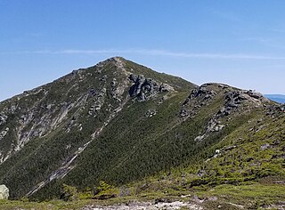
The summit of North Kinsman Mountain is viewless, but a short bushwhack to the east takes hikers to steep granite ledges that fall off to Kinsman Pond and offer views of Cannon Mountain, South Kinsman, Franconia Ridge, and Lonesome Lake.
Franconia is a town in Grafton County, New Hampshire, United States. The population was 1,083 at the 2020 census. Set in the White Mountains, Franconia is home to the northern half of Franconia Notch State Park. Parts of the White Mountain National Forest are in the eastern and southern portions of the town. The Appalachian Trail crosses the town.
Franconia Notch State Park is a public recreation area and nature preserve that straddles eight miles (13 km) of Interstate 93 as it passes through Franconia Notch, a mountain pass between the Kinsman Range and Franconia Range in the White Mountains of northern New Hampshire, United States. The northern part of the park, including Cannon Mountain and Echo and Profile lakes, is in the town of Franconia, and the southern part, including Lonesome Lake and the Flume, is in Lincoln. Attractions in the state park include the Flume Gorge and visitor center, the Old Man of the Mountain historical site, fishing in Echo Lake and Profile Lake, and miles of hiking, biking and ski trails.
Franconia Notch is a major mountain pass through the White Mountains of New Hampshire. Dominated by Cannon Mountain to the west and Mount Lafayette to the east, it lies principally within Franconia Notch State Park and is traversed by the Franconia Notch Parkway. The parkway required a special act of Congress to sidestep design standards for the Interstate highway system because it is only one lane in each direction.
Mount Lincoln is a 5,089-foot-high (1,551 m) mountain within the Franconia Range of the White Mountains of New Hampshire. Lincoln is located between Little Haystack and Mount Lafayette. All three overlook Franconia Notch. The west side of Lincoln drains into the main stem of the Pemigewasset River. The east side drains into Lincoln Brook, thence into the Franconia Branch of the Pemigewasset.
Mount Flume is a 4,328-foot (1,319 m) mountain at the southern end of the Franconia Range in the White Mountains of New Hampshire, United States. Mount Flume is the lowest in elevation of the peaks in the Franconia Range that are accessible by official hiking trails.
South Twin Mountain is a mountain located in Grafton County, New Hampshire, United States. The mountain is part of the Twin Range of the White Mountains. South Twin forms the high point of a north–south ridge, with North Twin Mountain lying approximately one mile to the north and Mount Guyot two miles (3.2 km) to the southeast. Galehead Mountain, a lower spur of South Twin, is to the west.
Mount Moosilauke is a 4,802-foot-high (1,464 m) mountain at the southwestern end of the White Mountains in the town of Benton, New Hampshire, United States. It is the tenth highest and most southwesterly of the 4,000 foot summits in the White Mountains.
Mount Cardigan is a prominent bare-rock summit in the towns of Orange and Alexandria in western New Hampshire, USA. While its peak is only 3,155 feet (962 m) above sea level, it has extensive areas of bare granite ledges and alpine scrub, giving it the feel to hikers of a much higher mountain. Most of the summit area was denuded by devastating forest fires in 1855.
Mount Carrigain is a mountain located in Grafton County, New Hampshire. The mountain is named after Phillip Carrigain, NH Secretary of State (1805–10), and is on the south side of the Pemigewasset Wilderness, the source of the East Branch of the Pemigewasset River in the heart of the White Mountains, between Franconia Notch and Crawford Notch. Carrigain is flanked to the northeast beyond Carrigain's Vose Spur by Mount Anderson and Mount Lowell across Carrigain Notch, and to the southwest by Mount Hancock. It has a fire tower at the summit, providing 360 degree views of the surrounding wilderness.
Kinsman Notch is a mountain pass located in the White Mountains of New Hampshire, United States. It is the westernmost of the major notches through the White Mountains. To the southeast, the valley of the notch is drained by the Lost River, leading to the Pemigewasset River, and ultimately the Merrimack, flowing into the Gulf of Maine. The northwest half of the notch is drained by Beaver Brook and the Wild Ammonoosuc River, part of the Connecticut River watershed leading to Long Island Sound.
Mount Field is a mountain located in Grafton County, New Hampshire. The mountain is named after Darby Field (1610–1649), who in 1642 made the first known ascent of Mount Washington. Mount Field is the highest peak of the Willey Range of the White Mountains. Mt. Field is flanked to the northwest by Mount Tom, and to the southwest by Mount Willey.
Mount Garfield is a mountain located in Grafton County, New Hampshire. The mountain is part of the White Mountains. Mt. Garfield is flanked to the east by South Twin Mountain, and to the southwest along Garfield Ridge by Mount Lafayette.
Mount Tripyramid is a mountain located in Grafton County, New Hampshire. Part of the Sandwich Range of the White Mountains, it has three distinct peaks – North, Middle, and South – along its mile-long summit ridge. North, at 4,160 ft (1,270 m), is the highest. Scaur Peak and The Fool Killer are subsidiary peaks to the northwest and northeast. To the southeast, Tripyramid is flanked by The Sleepers.
Galehead Mountain is a mountain located in Grafton County, New Hampshire. The mountain is part of the Twin Range of the White Mountains. Galehead is flanked to the east by South Twin Mountain, and to the west by Mount Garfield. The summit is reached by the Frost Trail which departs from Galehead Hut. There are several ways to reach the hut from one's car, the Gale River Trail from the northwest being the most direct.
Mount Guyot is a mountain located in Grafton County, New Hampshire. The mountain is named after Professor Arnold H. Guyot (1807–1884) of Princeton University, and is part of the Twin Range of the White Mountains. Mount Guyot is flanked to the northwest by South Twin Mountain, to the northeast by Mount Zealand, and to the south by Mount Bond. Guyot is on the northern boundary of the Pemigewasset Wilderness. The immediate area around the summit consists of high-altitude spruce-fir forest or krummholz.
Sandwich Mountain is a 3,983 ft (1,214 m) mountain located on the border between Carroll and Grafton counties, New Hampshire spanning parts of the towns of Sandwich and Waterville Valley, respectively. The mountain is part of the Sandwich Range of the White Mountains.
The Pemigewasset Wilderness is a 45,000-acre (182 km2) federally designated Wilderness Area in the heart of New Hampshire's White Mountains. It is a part of the White Mountain National Forest. It is New Hampshire's largest wilderness area.
Nubble Peak, also known as The Peak Above The Nubble, is a mountain located in Grafton County, New Hampshire. The mountain is part of the Twin Range of the White Mountains. A rock outcrop on its northwestern ridge is known as The Nubble, but topographic maps identify the formation as Haystack Mountain. Nubble Peak is flanked to the south by North Twin Mountain. The mountain is officially trailless and is one of New England's hundred highest summits.
The Cannon Balls is a mountain ridge located in Grafton County, New Hampshire. It is part of the Kinsman Range of the White Mountains. The ridge has three peaks with elevations of, from west to east, 3,693, 3,660, and 3,769 feet. The ridge takes its name from adjacent Cannon Mountain, on which a series of boulders, when viewed from the foot of the mountain, resemble an antique artillery cannon. The Cannon Balls are flanked to the northeast by Cannon Mountain, and to the southwest by Kinsman Mountain.
The Kinsman Range, also known as the Cannon–Kinsman Range, is a north–south range in the White Mountains of New Hampshire in the United States. Its highest point is 4,358-foot-high (1,328 m) Kinsman Mountain, followed by the 4,293-foot (1,309 m) North Peak of Kinsman, and 4,080-foot (1,240 m) Cannon Mountain, one of the richest in rock climbing routes in the Whites. All are official "Four-thousand footers". 3,478-foot (1,060 m) Mount Wolf is on the crest of the range south of Kinsman Mountain. Rounding out the range are 2,470-foot (750 m) Bald Peak on the west side of Kinsman Mountain and 2,530-foot (770 m) Mount Pemigewasset on the east side, overlooking Franconia Notch.
This page is based on this Wikipedia article Text is available under the CC BY-SA 4.0 license; additional terms may apply. Images, videos and audio are available under their respective licenses.