
The White Mountains Region is a tourism region designated by the New Hampshire Division of Travel and Tourism. It is located in northern New Hampshire in the United States and is named for the White Mountains, which cover most of the region. The southern boundary of the region begins at Piermont on the west, and runs east to Campton, then on to Conway and the Maine border. The northern boundary begins at Littleton and runs east to Gorham and the Maine border. The region to the north is known as the Great North Woods Region, which should not be confused with the larger and more general Great North Woods.
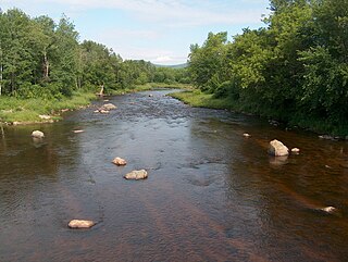
The Israel River, sometimes referred to as Israel's River, is a 23.2-mile-long (37.3 km) river in the White Mountains of New Hampshire, in the United States. It rises in the township of Low and Burbank's Grant and runs generally northwest along U.S. Route 2, traversing the towns of Jefferson and Lancaster, before joining the Connecticut River.

Crawford Notch is a major pass through the White Mountains of New Hampshire, located in Hart's Location. Roughly half of that town is contained in Crawford Notch State Park. The high point of the notch, at approximately 1,900 feet (580 m) above sea level, is at the southern end of the town of Carroll, near the Crawford Depot train station and Saco Lake, the source of the Saco River, which flows southward through the steep-sided notch. North of the high point of the notch, Crawford Brook flows more gently northwest to the Ammonoosuc River, a tributary of the Connecticut River.
The Great North Woods Region, also known as the North Country, is located at the northern tip of New Hampshire, United States, north of the White Mountains Region and is part of the larger Great North Woods. The Great North Woods is a tourism region of New Hampshire and is located in Coos County. The dividing line is loosely defined as running from Cushman, a hamlet within Dalton, to south of Berlin and east to the Maine border, roughly following US Route 2.

The High Huts of the White Mountains are eight mountain huts in the White Mountains of New Hampshire, owned and maintained by the Appalachian Mountain Club. They are modeled after similar huts in the Alps and positioned at intervals along the Appalachian Trail, allowing "thru-hikers" who hike the entire Appalachian Trail to benefit from their services. They are generally separated by six to eight miles, about a day's hike.
The Ossipee Mountains are a small mountain range in the New England state of New Hampshire, United States. The remains of an ancient volcanic ring dike, they lie north of Lake Winnipesaukee, east of Squam Lake, and south of the Sandwich Range, the southernmost of the White Mountains. 2,990 ft (910 m) Mount Shaw is their highest point.

North Baldface is a 3,606-foot (1,099 m) mountain in the township of Bean's Purchase, New Hampshire in the eastern White Mountains. It gets its name from its steep barren southeast face. Along with the neighboring summit South Baldface, it is a popular hiking destination, especially in the summer. The two mountains are ascended by the Slippery Brook, Baldface Knob, Baldface Circle, Meader Ridge, and Bicknell Ridge trails.

The Baldface-Royce Range is a range of mountains in western Maine and eastern New Hampshire, in the United States. They are located in the town of Chatham, New Hampshire, and the townships of Bean's Purchase, New Hampshire, and Batchelders Grant, Maine, in the eastern part of the White Mountains.
Mount Tremont, elevation 3,371 feet (1,027 m), is a mountain in Carroll and Grafton counties in the White Mountains of New Hampshire. It stands southwest of the town of Bartlett and directly south of Crawford Notch. It is flanked to the east by Bartlett Haystack mountain, to the northwest by the Sawyer River valley, and to the northeast by the Saco River valley. The mountain is crossed by the Brunel and Mount Tremont trails.
Mount Success, formerly Ingalls Mountain, is a mountain in the Mahoosuc Range with an elevation of 3,565 feet (1,087 m). It is located in Coos County, New Hampshire.

Mount Meader, elevation 2,782 feet (848 m), is a mountain in the Baldface-Royce Range, located in Coos County, New Hampshire. It is reached by the Basin Rim, Mount Meader, and Meader Ridge trails. It is flanked to the southwest by Eagle Crag, and to the northeast by West Royce Mountain.
Mount Rosebrook is a mountain in New Hampshire's White Mountains. It is part of the Bretton Woods Ski Resort, rising to the southwest across U.S. Route 302 from the Mount Washington Hotel. The elevation of the summit is 3,004 feet (916 m). It is on the crest of the Rosebrook Mountains, with 2,746-foot (837 m) Mount Oscar to the northwest and 3,043-foot (928 m) Mount Stickney to the southeast.

Mount Forest, locally spelled Mount Forist, is a mountain located in Coös County, New Hampshire, in the United States. The mountain has an elevation of 2,031 feet (619 m), and is a prominent feature of the city of Berlin's landscape. It is sometimes referred to as Elephant Mountain due to its appearance from Berlin.
The Crescent Range, sometimes referred to as the Randolph Mountains, is located in the White Mountains of New Hampshire in the United States. The highest peak in the range is Black Crescent Mountain, with an elevation of 3,264 feet (995 m).
Mount Cilley is 2,227-foot (679 m) peak in the White Mountains of New Hampshire. The wooded mountain is in the town of Woodstock, west of the Pemigewasset River and northeast of Elbow Pond. It was named for General Joseph Cilley.

The Crawford Path is an 8.5-mile-long (13.7 km) hiking trail in the White Mountains of New Hampshire that is considered to be the United States' oldest continuously maintained hiking trail. It travels from Crawford Notch to the summit of Mount Washington (Agiocochook). The first iteration of the Crawford Path was cut in 1819 by Ethan Allen Crawford and his father, Abel Crawford. The trail ascends a cumulative 4,900 feet (1,500 m), first through densely wooded forest for about 3.1 miles (5.0 km), then following the exposed southern ridge of the Presidential Range mostly above the treeline.

Mount Pemigewasset, or Indian Head, is a mountain in Franconia Notch in the White Mountains in Grafton County, New Hampshire, United States. It lies near the town of Lincoln.