
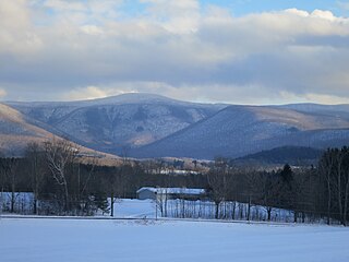
Sugar Hill is a town in Grafton County, New Hampshire, United States. The population was 647 at the 2020 census, an increase over the figure of 563 tabulated in 2010. The town overlooks the White Mountain National Forest, with views of the Presidential, Franconia, Kinsman and Dalton ranges. Sugar Hill was incorporated as a town in 1962, the most recent in New Hampshire.

Mount Washington, is an ultra-prominent mountain in the state of New Hampshire. It is the highest peak in the Northeastern United States at 6,288.2 ft (1,916.6 m) and the most topographically prominent mountain east of the Mississippi River.

The White Mountains are a mountain range covering about a quarter of the state of New Hampshire and a small portion of western Maine in the United States. They are a subrange of the northern Appalachian Mountains and the most rugged mountains in New England. Several of the higher peaks contain an Alpine tundra. The range is heavily visited due to its proximity to Boston, New York City, and Montreal.

Mount Monadnock, or Grand Monadnock, is a mountain in the towns of Jaffrey and Dublin, New Hampshire. It is the most prominent mountain peak in southern New Hampshire and is the highest point in Cheshire County. It lies 38 miles (61 km) southwest of Concord and 62 miles (100 km) northwest of Boston. At 3,165 feet (965 m), Mount Monadnock is nearly 1,000 feet (305 m) higher than any other mountain peak within 30 miles (48 km) and rises 2,000 feet (610 m) above the surrounding landscape. Monadnock's bare, isolated, and rocky summit provides expansive views. It is known for being featured in the writings of Ralph Waldo Emerson and Henry David Thoreau.
Mount Greylock is the highest point in Massachusetts at 3,489 feet. Located in northwest region of the state, it is part of the Taconic Mountains, a geologically distinct range from the nearby Berkshires and Green Mountains. Expansive views and a small area of sub-alpine forest characterize its upper reaches. A seasonal automobile road crosses the summit area near three structures from the 1930s, which together constitute a small, "National Historic District." Various hiking paths including the Appalachian Trail traverse the area, which is part of the larger Mount Greylock State Reservation.

The White Mountains Region is a tourism region designated by the New Hampshire Division of Travel and Tourism. It is located in northern New Hampshire in the United States and is named for the White Mountains, which cover most of the region. The southern boundary of the region begins at Piermont on the west, and runs east to Campton, then on to Conway and the Maine border. The northern boundary begins at Littleton and runs east to Gorham and the Maine border. The region to the north is known as the Great North Woods Region, which should not be confused with the larger and more general Great North Woods.

Franconia Notch State Park is a public recreation area and nature preserve that straddles eight miles (13 km) of Interstate 93 as it passes through Franconia Notch, a mountain pass between the Kinsman Range and Franconia Range in the White Mountains of northern New Hampshire, United States. The northern part of the park, including Cannon Mountain and Echo and Profile lakes, is in the town of Franconia, and the southern part, including Lonesome Lake and the Flume, is in Lincoln. Attractions in the state park include the Flume Gorge and visitor center, the Old Man of the Mountain historical site, fishing in Echo Lake and Profile Lake, and miles of hiking, biking and ski trails.
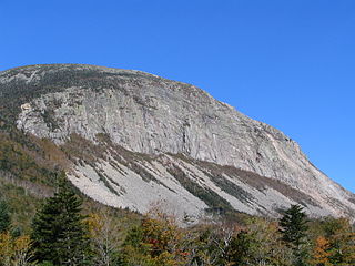
Cannon Mountain is a 4,080-foot (1,240 m) peak in the White Mountains of New Hampshire. It is known for both its technical rock and ice climbing on its cliff face and skiing at Cannon Mountain Ski Area. It was also home to the Old Man of the Mountain, until that formation collapsed on May 3, 2003.

The Metacomet-Monadnock Trail is a 114-mile-long (183 km) hiking trail that traverses the Metacomet Ridge of the Pioneer Valley region of Massachusetts and the central uplands of Massachusetts and southern New Hampshire. Although less than 70 miles (110 km) from Boston and other large population centers, the trail is considered remarkably rural and scenic and includes many areas of unique ecologic, historic, and geologic interest. Notable features include waterfalls, dramatic cliff faces, exposed mountain summits, woodlands, swamps, lakes, river floodplain, farmland, significant historic sites, and the summits of Mount Monadnock, Mount Tom and Mount Holyoke. The Metacomet-Monadnock Trail is maintained largely through the efforts of the Western Massachusetts Chapter of the Appalachian Mountain Club (AMC). Much of the trail is a portion of the New England National Scenic Trail.
Mount Cardigan is a prominent bare-rock summit in the towns of Orange and Alexandria in western New Hampshire, USA. While its peak is only 3,155 feet (962 m) above sea level, it has extensive areas of bare granite ledges and alpine scrub, giving it the feel to hikers of a much higher mountain. Most of the summit area was denuded by devastating forest fires in 1855.
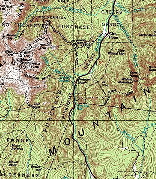
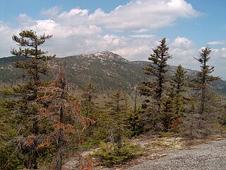
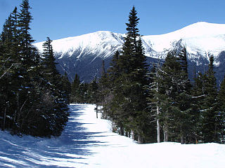
Pinkham Notch is a mountain pass in the White Mountains of north-central New Hampshire, United States. The notch is a result of extensive erosion by the Laurentide Ice Sheet during the Wisconsinian ice age. Pinkham Notch was eroded into a glacial U-shaped valley whose walls are formed by the Presidential, Wildcat, and Carter-Moriah ranges. Due to the volatility of the area's climate and rugged character of the terrain, a number of rare or endemic ecosystems have developed throughout the notch.

Wildcat Mountain is a mountain located in Coos County, northern New Hampshire, United States. The mountain is part of the Carter-Moriah Range of the White Mountains, on the east side of Pinkham Notch. Wildcat Mountain faces Carter Dome across Carter Notch to the northeast, and Mount Washington across Pinkham Notch to the west.
Waterville Valley is a ski resort in Waterville Valley, New Hampshire, United States. It is located within the White Mountain National Forest. Built on Mount Tecumseh, with a summit elevation of 3,997 feet (1,218 m) above sea level, the ski trails extend to a high point on the south ridge of the mountain at 3,840 feet (1,170 m), offering a vertical drop of 2,020 feet (615 m). The ski area has 11 lifts, including two high-speed quads and the slopes primarily face east and northeast.
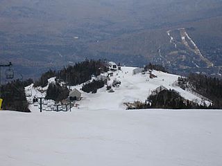
Wildcat Mountain Ski Area is a ski area located on Wildcat Mountain near Jackson, New Hampshire, United States, in the Mount Washington Valley. Its vertical drop of 2,112 feet (644 m) is the second largest in New Hampshire and the ninth largest in New England.

Mount Doublehead is a twin-peaked mountain in eastern New Hampshire, United States. It is located in the town of Jackson, Carroll County, in the eastern White Mountains. North Doublehead has an elevation of 3,053 feet (930.5 m) above sea level, while South Doublehead has an elevation of 2,939 ft (895.8 m).

Mount Rowe, elevation 1,680 feet (510 m), is a mountain located north of Gunstock Mountain in the Belknap Range, Belknap County, New Hampshire, United States. It has been home to multiple alpine ski operations, including the original Gunstock Mountain Resort single chairlift, the Belknap Ski Jumps, and the defunct Alpine Ridge/Mt. Rowe ski area.

Mount Whittier Ski Area was an alpine ski area located in West Ossipee, New Hampshire. Though it shared a name with a nearby mountain in the Ossipee Range, the ski area was actually located on Nickerson Mountain.

Black Mountain Ski Area is an alpine ski area located in Jackson, New Hampshire, United States. First used in the mid-1930s, it has operated seasonally since shortly after World War II. Black Mountain offers terrain for all abilities, including slopes for novices, cruising trails for intermediates, and black diamond trails for experts. The terrain is served by two chairlifts and three surface lifts. In addition to alpine skiing and snowboarding, it also offers summer camps and equine programs.
Bear Mountain is a 3,219-foot (981 m) mountain located in Bartlett, New Hampshire, USA. Bear Mountain is flanked to the northwest, across Bear Notch, by Bartlett Haystack. To the east is Table Mountain, followed by Big Attitash Mountain. The north side of Bear Mountain drains via Louisville Brook and Albany Brook to the Saco River in Bartlett. The southern slopes of the mountain drain to the Swift River, on the southwest via Douglas Brook and on the southeast via Cilley Brook, which joins the Swift River at Rocky Gorge.

Nickerson Mountain is a mountain located in Carroll County, New Hampshire, in the northeastern Ossipee Mountains. The peak was also once known as Mount Whittier; however, the USGS has since labelled a mountain to the immediate west with the name.
