Wildcat Mountain (New Hampshire)

Last updated
Wildcat Mountain A
WildcatA.jpg
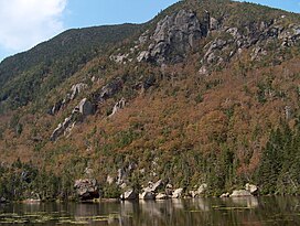
Wildcat A rises over Carter Notch
Highest point
Elevation 4,422 ft (1,348 m)
Prominence 1,034 ft (315 m)
Listing White Mountain 4,000-footers
Coordinates 44°15′32″N71°12′05″W / 44.25889°N 71.20139°W / 44.25889; -71.20139
Geography
Location Coös County, New Hampshire, U.S.
Parent range Carter-Moriah Range
Topo map USGS Carter Dome
Wildcat Mountain D
Highest point
Elevation 4,062 ft (1,238 m)
Prominence 287 ft (87 m)
Listing White Mountain 4,000-footers
Climbing
Easiest route Via Wildcat Mountain Ski Area gondola lift

Wildcat Mountain is a mountain located in Coos County, northern New Hampshire, United States. The mountain is part of the Carter-Moriah Range of the White Mountains, on the east side of Pinkham Notch. Wildcat Mountain faces Carter Dome across Carter Notch to the northeast, and Mount Washington across Pinkham Notch to the west.

Contents

Wildcat Mountain has five summits — A, B, C, D, and E — along Wildcat Ridge, which curves two miles (3 km) to the south and west. Both A, at 4,422 feet (1,348 m), and D, at 4,062 feet (1,238 m), are considered "four-thousand footers". B, with an elevation of 4,305 feet (1,312 m), and C, at 4,285 feet (1,306 m), lack the topographic prominence to be considered more than subpeaks of Wildcat A. Likewise, the E peak, at 4,046 feet (1,233 m), is considered to be a subpeak of the higher D peak (the E peak was formerly believed to be the higher of the two, and used to appear on the official list of four-thousand footers, but current topographic maps reveal the D peak to be the higher summit).

The Appalachian Trail, which extends over 2,170 miles (3,490 km) from Georgia to Maine, climbs up from the Appalachian Mountain Club's Joe Dodge Lodge in Pinkham Notch and traverses the summits of the Wildcat Ridge, continuing on to Carter Dome.

The Wildcat Mountain Ski Area is one of the best-known alpine skiing resorts in New England, with lifts from the base on NH Route 16 in Pinkham Notch 2,112 ft (644 m) up to the D summit. The area has 49 trails on 225 acres (0.91 km2), including Polecat Trail—the longest ski trail in New Hampshire. The Wildcat Valley Trail, an ungroomed cross-country ski trail, leads from the summit down to Jackson, New Hampshire, dropping 3,240 ft (990 m) in 11.1 miles (17.9 km). Cut in 1972, it is one of the best-known routes in the extensive trail system maintained by the Jackson Ski Touring Foundation.

Climate

Climate data for Wildcat Mountain 44.2558 N, 71.1981 W, Elevation: 4,016 ft (1,224 m) (1991–2020 normals)
MonthJanFebMarAprMayJunJulAugSepOctNovDecYear
Average high °F (°C)19.3
(−7.1)
21.2
(−6.0)
27.9
(−2.3)
39.6
(4.2)
52.7
(11.5)
60.9
(16.1)
65.6
(18.7)
64.3
(17.9)
58.5
(14.7)
46.2
(7.9)
34.3
(1.3)
24.8
(−4.0)
42.9
(6.1)
Daily mean °F (°C)11.4
(−11.4)
12.8
(−10.7)
19.3
(−7.1)
31.2
(−0.4)
44.1
(6.7)
53.0
(11.7)
57.9
(14.4)
56.7
(13.7)
50.5
(10.3)
38.7
(3.7)
27.5
(−2.5)
17.7
(−7.9)
35.1
(1.7)
Average low °F (°C)3.5
(−15.8)
4.4
(−15.3)
10.7
(−11.8)
22.7
(−5.2)
35.6
(2.0)
45.1
(7.3)
50.3
(10.2)
49.0
(9.4)
42.5
(5.8)
31.3
(−0.4)
20.8
(−6.2)
10.6
(−11.9)
27.2
(−2.7)
Average precipitation inches (mm)5.36
(136)
4.63
(118)
5.53
(140)
6.65
(169)
6.19
(157)
6.94
(176)
6.78
(172)
5.81
(148)
5.84
(148)
9.12
(232)
6.91
(176)
6.54
(166)
76.3
(1,938)
Source: PRISM Climate Group [1]

See also

Related Research Articles

<span class="mw-page-title-main">White Mountains (New Hampshire)</span> Mountain range in New Hampshire and Maine, United States

The White Mountains are a mountain range covering about a quarter of the state of New Hampshire and a small portion of western Maine in the United States. They are part of the northern Appalachian Mountains and the most rugged mountains in New England. Several of the higher peaks contain an Alpine tundra. The range is heavily visited due to its proximity to Boston, New York City, and Montreal.

<span class="mw-page-title-main">Mount Adams (New Hampshire)</span> Mountain in New Hampshire, United States

Mount Adams, elevation 5,793 feet (1,766 m) above sea level, is a mountain in New Hampshire, the second highest peak in the Northeast United States after its nearby neighbor, Mount Washington. Located in the northern Presidential Range, Mount Adams was named after John Adams, the second President of the United States. It was given this name on July 31, 1820. To the northeast is Mount Madison and to the southwest is Mount Jefferson. From the summit, Mount Washington can be seen directly to the south.

<span class="mw-page-title-main">Mount Eisenhower</span> Mountain in the American state of New Hampshire

Mount Eisenhower, formerly Mount Pleasant, is a mountain in the Presidential Range in the White Mountains of New Hampshire approximately 4,760 ft (1,450 m) high. Named after President Dwight D. Eisenhower, its summit offers a 360° view. It is inaccessible by road.

<span class="mw-page-title-main">Mount Madison</span>

Mount Madison is a 5,367-foot (1,636 m) mountain in the Presidential Range of New Hampshire in the United States. It is named after the fourth U.S. President, James Madison.

Four-thousand footers are a group of forty-eight mountains in New Hampshire at least 4,000 feet (1,200 m) above sea level. To qualify for inclusion a peak must also meet the more technical criterion of topographic prominence important in the mountaineering sport of peak-bagging.

<span class="mw-page-title-main">Mount Lafayette</span> Mountain in New Hampshire

Mount Lafayette is a 5,249-foot (1,600 m) mountain at the northern end of the Franconia Range in the White Mountains of New Hampshire, United States. It lies in the town of Franconia in Grafton County, and appears on the New England Fifty Finest list of the most topographically prominent peaks in New England. The mountain's upper reaches are located in the alpine zone, an area where only dwarf vegetation exists due to the harsh climate.

<span class="mw-page-title-main">Carter Dome</span> Mountain in United States of America

Carter Dome, or simply The Dome, is a mountain located in Coos County, New Hampshire. The mountain is part of the Carter-Moriah Range of the White Mountains, which runs along the northern east side of Pinkham Notch. Carter Dome is flanked to the northeast by Mount Hight and to the southwest by Wildcat Mountain.

<span class="mw-page-title-main">Mount Moosilauke</span> Mountain in the American state of New Hampshire

Mount Moosilauke is a 4,802-foot-high (1,464 m) mountain at the southwestern end of the White Mountains in the town of Benton, New Hampshire, United States. It is the tenth highest and most southwesterly of the 4,000 foot summits in the White Mountains.

<span class="mw-page-title-main">Mount Monroe</span> Mountain in the American state of New Hampshire

Mount Monroe is a 5,372-foot-high (1,637 m) mountain peak southwest of Mount Washington in the Presidential Range of the White Mountains in New Hampshire, United States. It is named for American President James Monroe and is the fourth highest mountain on the 4000 footers list for New Hampshire. The Appalachian Trail skirts its summit, which is the next highest peak on or near the trail north of Mount Rogers in Virginia. The Lakes of the Clouds, and its AMC hut, lie nestled at the col between Mount Monroe and neighboring Mount Washington.

<span class="mw-page-title-main">Pinkham Notch</span> Mountain pass in New Hampshire

Pinkham Notch is a mountain pass in the White Mountains of north-central New Hampshire, United States. The notch is a result of extensive erosion by the Laurentide Ice Sheet during the Wisconsinian ice age. Pinkham Notch was eroded into a glacial U-shaped valley whose walls are formed by the Presidential, Wildcat, and Carter-Moriah ranges. Due to the volatility of the area's climate and rugged character of the terrain, a number of rare or endemic ecosystems have developed throughout the notch.

<span class="mw-page-title-main">Middle Carter Mountain</span> Mountain in the state of New Hampshire

Middle Carter Mountain is a mountain located in Coos County, New Hampshire. The mountain is part of the Carter-Moriah Range of the White Mountains, which runs along the northern east side of Pinkham Notch. Middle Carter is flanked to the north by North Carter Mountain and to the southwest by South Carter Mountain. The summit of Middle Carter is wooded, but there are views from the ridgecrest not far from the summit.

<span class="mw-page-title-main">North Carter Mountain</span>

North Carter Mountain is a mountain located in Coos County, New Hampshire. The mountain is part of the Carter-Moriah Range of the White Mountains, which runs along the northern east side of Pinkham Notch. North Carter is flanked to the northeast by Imp Mountain, and to the southwest by Middle Carter Mountain.

<span class="mw-page-title-main">Mount Moriah (New Hampshire)</span> Mountain in the state of New Hampshire

Mount Moriah is a mountain located in Coos County, New Hampshire. The mountain is part of the Carter-Moriah Range of the White Mountains, which runs along the northern east side of Pinkham Notch. The summit is approximately 5 miles (8 km) southeast of the center of the town of Gorham. Mount Moriah is flanked to the northeast by Middle Moriah Mountain and to the southwest by Imp Mountain. The summit is located on the Appalachian Trail and affords views in all directions.

<span class="mw-page-title-main">Mount Carrigain</span> Mountain in the state of New Hampshire

Mount Carrigain is a mountain located in Grafton County, New Hampshire. The mountain is named after Phillip Carrigain, NH Secretary of State (1805–10), and is on the south side of the Pemigewasset Wilderness, the source of the East Branch of the Pemigewasset River in the heart of the White Mountains, between Franconia Notch and Crawford Notch. Carrigain is flanked to the northeast beyond Carrigain's Vose Spur by Mount Anderson and Mount Lowell across Carrigain Notch, and to the southwest by Mount Hancock. It has a fire tower at the summit, providing 360 degree views of the surrounding wilderness.

<span class="mw-page-title-main">Boott Spur</span>

Boott Spur is a minor peak located in Coos County, New Hampshire. The mountain is named after Francis Boott (1792–1863), and is part of the Presidential Range of the White Mountains. Boott Spur stands on the shoulder of Mount Washington, above the south side of the headwall of Tuckerman Ravine.

<span class="mw-page-title-main">Carter-Moriah Range</span> Part of the White Mountains of New Hampshire

<span class="mw-page-title-main">Mount Bigelow (Maine)</span>

Mount Bigelow is a long mountain ridge with several summits. It is located in Franklin County and Somerset County, Maine. It is one of Maine's highest summits. The mountain is named after Major Timothy Bigelow who climbed the rugged summit in late October 1775 "for the purpose of observation." Major Bigelow was one of Colonel Benedict Arnold's four division commanders during the 1775 Invasion of Canada. The expeditionary force passed along the Dead River on the northern edge of the Bigelow Range, now dammed into Flagstaff Lake.

Mount Isolation is a mountain located in Coos County, New Hampshire. The mountain is part of the Presidential Range of the White Mountains. Mount Isolation is the highest peak on the Montalban Ridge which extends south from Boott Spur.

Mount Cabot is a mountain located in Coos County, in the U.S. state of New Hampshire. The mountain is the highest peak of the Pilot Range of the White Mountains. Cabot is flanked to the northeast by The Bulge, and to the south of Bunnell Notch by Terrace Mountain. Mount Cabot was named in honor of the Italian explorer Sebastian Cabot.

References

  1. "PRISM Climate Group, Oregon State University". PRISM Climate Group, Oregon State University. Retrieved October 26, 2023. To find the table data on the PRISM website, start by clicking Coordinates (under Location); copy Latitude and Longitude figures from top of table; click Zoom to location; click Precipitation, Minimum temp, Mean temp, Maximum temp; click 30-year normals, 1991-2020; click 800m; click Retrieve Time Series button.