
The White Mountain National Forest (WMNF) is a federally managed forest contained within the White Mountains in the northeastern United States. It was established in 1918 as a result of the Weeks Act of 1911; federal acquisition of land had already begun in 1914. It has a total area of 750,852 acres (303,859 ha). Most of the WMNF is in New Hampshire; a small part is in the neighboring state of Maine. While often casually referred to as a park, this is a national forest, used not only for hiking, camping, and skiing but for logging and other limited commercial purposes. The WMNF is the only national forest located in either New Hampshire or Maine, and is the most eastern national forest in the United States. Most of the major peaks over 4,000 feet high for peak-bagging in New Hampshire are located in the national forest. Over 100 miles (160 km) of the Appalachian Trail traverses the White Mountain National Forest. In descending order of land area the forest lies in parts of Grafton, Coos, and Carroll counties in New Hampshire, and Oxford County in Maine.

Mount Lafayette is a 5,249-foot (1,600 m) mountain at the northern end of the Franconia Range in the White Mountains of New Hampshire, United States. It lies in the town of Franconia in Grafton County, and appears on the New England Fifty Finest list of the most topographically prominent peaks in New England. The mountain's upper reaches are located in the alpine zone, an area where only dwarf vegetation exists due to the harsh climate.

Mount Lincoln is a 5,089-foot-high mountain within the Franconia Range of the White Mountains of New Hampshire. Lincoln is located between Little Haystack and Mount Lafayette. All three overlook Franconia Notch. The west side of Lincoln drains into the main stem of the Pemigewasset River. The east side drains into Lincoln Brook, thence into the Franconia Branch of the Pemigewasset.

South Twin Mountain is a mountain located in Grafton County, New Hampshire. The mountain is part of the Twin Range of the White Mountains. South Twin forms the high point of a north-south ridge, with North Twin Mountain lying approximately one mile to the north and Mount Guyot two miles (3 km) to the southeast. Galehead Mountain, a lower spur of South Twin, is to the west.

Mount Moosilauke is a 4,802-foot-high (1,464 m) mountain at the southwestern end of the White Mountains in the town of Benton, New Hampshire, United States. It is the tenth highest and most southwesterly of the 4,000 foot summits in the White Mountains.

Mount Monroe is a 5,372-foot-high (1,637 m) mountain peak southwest of Mount Washington in the Presidential Range of the White Mountains in New Hampshire, United States. It is named for American President James Monroe and is the fourth highest mountain on the 4000 footers list for New Hampshire. The Appalachian Trail skirts its summit, which is the next highest peak on or near the trail north of Mount Rogers in Virginia. The Lakes of the Clouds, and its AMC hut, lie nestled at the col between Mount Monroe and neighboring Mount Washington.

The North Shore Mountains are a mountain range overlooking Vancouver in British Columbia, Canada. Their southernmost peaks are visible from most areas in Vancouver and form a distinctive backdrop for the city.

The Camelsfoot Range is a sub-range of the Chilcotin Ranges subdivision of the Pacific Ranges of the Coast Mountains in British Columbia. The Fraser River forms its eastern boundary. The range is approximately 90 km at its maximum length and less than 30 km wide at its widest.

The East Branch of the Pemigewasset River is a 15.8-mile-long (25.4 km) river located in the White Mountains of New Hampshire in the United States. It is a tributary of the Pemigewasset River, part of the Merrimack River watershed.

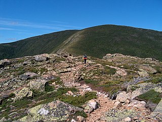
Owl's Head is a 4,025-foot (1,227 m) mountain in Franconia, New Hampshire. It lies between the Franconia Branch of the Pemigewasset River and Lincoln Brook, in the Pemigewasset Wilderness of the White Mountain National Forest.

Mount Zealand, or Zealand Mountain, is a mountain located in the White Mountains, in Grafton County, New Hampshire. Zealand stands on a spur ridge northeast of Mount Guyot, and facing Whitewall Mountain to the east across Zealand Notch.

Mount Garfield is a mountain located in Grafton County, New Hampshire. The mountain is part of the White Mountains. Mt. Garfield is flanked to the east by South Twin Mountain, and to the southwest along Garfield Ridge by Mount Lafayette.

Galehead Mountain is a mountain located in Grafton County, New Hampshire. The mountain is part of the Twin Range of the White Mountains. Galehead is flanked to the east by South Twin Mountain, and to the west by Mount Garfield. The summit is reached by the Frost Trail which departs from Galehead Hut. There are several ways to reach the hut from one's car, the Gale River Trail from the northwest being the most direct.
Mount Bond is a mountain located in Grafton County, New Hampshire, United States. The mountain is named after Professor George P. Bond (1825–1865) of Harvard University, and is the southernmost extension of the Twin Range of the White Mountains. Mount Bond is flanked to the north by Mount Guyot.
Mount Guyot is a mountain located in Grafton County, New Hampshire. The mountain is named after Professor Arnold H. Guyot (1807–1884) of Princeton University, and is part of the Twin Range of the White Mountains. Mount Guyot is flanked to the northwest by South Twin Mountain, to the northeast by Mount Zealand, and to the south by Mount Bond. Guyot is on the northern boundary of the Pemigewasset Wilderness. The immediate area around the summit consists of high-altitude spruce-fir forest or krummholz.
The Pemigewasset Wilderness is a 45,000-acre (182 km2) federally designated Wilderness Area in the heart of New Hampshire's White Mountains. It is a part of the White Mountain National Forest. It is New Hampshire's largest wilderness area.

Zealand Notch is a mountain pass in the White Mountains of New Hampshire, United States. It is located in the towns of Bethlehem and Lincoln, near the northeastern corner of the Pemigewasset Wilderness. The center of the notch is traversed by hiking trails and is approximately 2 miles (3 km) from the nearest road. Zealand Pond, Zealand Falls, and the Zealand Falls hut are located near the height of land.

The Cannon Balls is a mountain ridge located in Grafton County, New Hampshire. It is part of the Kinsman Range of the White Mountains. The ridge has three peaks with elevations of, from west to east, 3,693, 3,660, and 3,769 feet. The ridge takes its name from adjacent Cannon Mountain, on which a series of boulders, when viewed from the foot of the mountain, resemble an antique artillery cannon. The Cannon Balls are flanked to the northeast by Cannon Mountain, and to the southwest by Kinsman Mountain.

The Franconia Range is a mountain range located in the White Mountains of the U.S. state of New Hampshire. It is the second-highest range of peaks in the White Mountains.

The Kinsman Range, also known as the Cannon–Kinsman Range, is a north–south range in the White Mountains of New Hampshire in the United States. Its highest point is 4,358-foot-high (1,328 m) Kinsman Mountain, followed by the 4,293-foot (1,309 m) North Peak of Kinsman, and 4,080-foot (1,240 m) Cannon Mountain, one of the richest in rock climbing routes in the Whites. All are official "Four-thousand footers". 3,478-foot (1,060 m) Mount Wolf is on the crest of the range south of Kinsman Mountain. Rounding out the range is 2,470-foot (750 m) Bald Peak on the west side of Kinsman Mountain.
