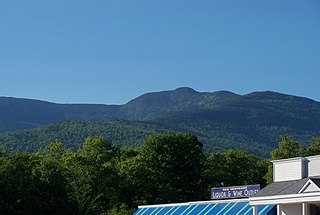
The White Mountains are a mountain range covering about a quarter of the state of New Hampshire and a small portion of western Maine in the United States. They are part of the northern Appalachian Mountains and the most rugged mountains in New England. The range is heavily visited due to its proximity to Boston, New York City, and Montreal.
Bean's Purchase is a township in Coös County, New Hampshire, United States. The purchase lies entirely within the White Mountain National Forest. The population was zero as of the 2020 census.

The White Mountain National Forest (WMNF) is a federally managed forest contained within the White Mountains in the northeastern United States. It was established in 1918 as a result of the Weeks Act of 1911; federal acquisition of land had already begun in 1914. It has a total area of 750,852 acres (303,859 ha). Most of the WMNF is in New Hampshire; a small part is in the neighboring state of Maine.
Four-thousand footers are a group of forty-eight mountains in New Hampshire at least 4,000 feet (1,200 m) above sea level. To qualify for inclusion a peak must also meet the more technical criterion of topographic prominence important in the mountaineering sport of peak-bagging.
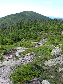
Carter Dome, or simply The Dome, is a mountain located in Coos County, New Hampshire. The mountain is part of the Carter-Moriah Range of the White Mountains, which runs along the northern east side of Pinkham Notch. Carter Dome is flanked to the northeast by Mount Hight and to the southwest by Wildcat Mountain.

The Peabody River is a 12.9-mile-long (20.8 km) river in the White Mountains of New Hampshire in the United States. It is a tributary of the Androscoggin River, which flows south and east into Maine, joining the Kennebec River near the Atlantic Ocean.
Mount Pierce is a mountain in the Presidential Range in the White Mountains of New Hampshire that is approximately 4,310 feet (1,310 m) high. Formerly called Mount Clinton for 19th-century governor DeWitt Clinton of New York, in 1913 it was renamed after President Franklin Pierce (1804–1869), the only president born in New Hampshire, although it was several decades before the name was widely recognized. Its summit offers a wide view of New Hampshire's mountains.

Pinkham Notch is a mountain pass in the White Mountains of north-central New Hampshire, United States. The notch is a result of extensive erosion by the Laurentide Ice Sheet during the Wisconsinian ice age. Pinkham Notch was eroded into a glacial U-shaped valley whose walls are formed by the Presidential, Wildcat, and Carter-Moriah ranges. Due to the volatility of the area's climate and rugged character of the terrain, a number of rare or endemic ecosystems have developed throughout the notch.
The Appalachian National Scenic Trail spans fourteen U.S. states during its roughly 2,200 miles (3,500 km)-long journey: Georgia, North Carolina, Tennessee, Virginia, West Virginia, Maryland, Pennsylvania, New Jersey, New York, Connecticut, Massachusetts, Vermont, New Hampshire, and Maine. The southern end is at Springer Mountain, Georgia, and it follows the ridgeline of the Appalachian Mountains, crossing many of its highest peaks and running almost continuously through wilderness before reaching the northern end at Mount Katahdin, Maine.

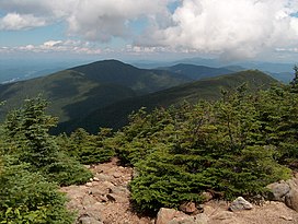
South Carter Mountain is a mountain located in Coos County, New Hampshire. The mountain is part of the Carter-Moriah Range of the White Mountains, which runs along the northern east side of Pinkham Notch. South Carter is flanked to the northeast by Middle Carter Mountain and to the southeast Mount Hight.
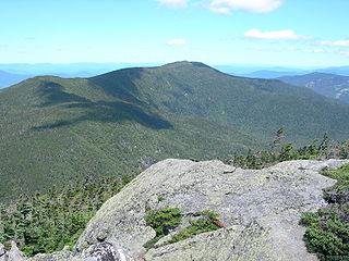
Middle Carter Mountain is a mountain located in Coos County, New Hampshire. The mountain is part of the Carter-Moriah Range of the White Mountains, which runs along the northern east side of Pinkham Notch. Middle Carter is flanked to the north by North Carter Mountain and to the southwest by South Carter Mountain. The summit of Middle Carter is wooded, but there are views from the ridgecrest not far from the summit.

North Carter Mountain is a mountain located in Coos County, New Hampshire. The mountain is part of the Carter-Moriah Range of the White Mountains, which runs along the northern east side of Pinkham Notch. North Carter is flanked to the northeast by Imp Mountain, and to the southwest by Middle Carter Mountain.
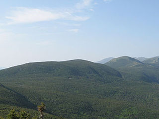
Mount Moriah is a mountain located in Coos County, New Hampshire. The mountain is part of the Carter-Moriah Range of the White Mountains, which runs along the northern east side of Pinkham Notch. The summit is approximately 5 miles (8 km) southeast of the center of the town of Gorham. Mount Moriah is flanked to the northeast by Middle Moriah Mountain and to the southwest by Imp Mountain. The summit is located on the Appalachian Trail and affords views in all directions.
Middle Moriah Mountain is a mountain located in Coos County, New Hampshire. The mountain is part of the Carter-Moriah Range of the White Mountains, which runs along the northern east side of Pinkham Notch. Middle Moriah is flanked to the northeast by Shelburne Moriah Mountain, and to the southwest by Mount Moriah.
Shelburne Moriah Mountain is a mountain located in Coos County, New Hampshire. The mountain is part of the Carter-Moriah Range of the White Mountains, which runs along the northern east side of Pinkham Notch. Shelburne Moriah is flanked to the southwest by Middle Moriah Mountain. It is the northernmost Moriah Range summit along the Appalachian Trail, which crosses the Androscoggin River at Shelburne, New Hampshire, and continues north into the Mahoosuc Range.

Wildcat Mountain is a mountain located in Coos County, northern New Hampshire, United States. The mountain is part of the Carter-Moriah Range of the White Mountains, on the east side of Pinkham Notch. Wildcat Mountain faces Carter Dome across Carter Notch to the northeast, and Mount Washington across Pinkham Notch to the west.

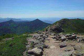
The Carter-Moriah Range of mountains is located in the White Mountains, in Coos County, New Hampshire. The range forms the northern east side of Pinkham Notch, opposite the northern Presidential Range. The range is also referred to as the Carter Range.

The Franconia Range is a mountain range located in the White Mountains of the U.S. state of New Hampshire. It is the second-highest range of peaks in the White Mountains.