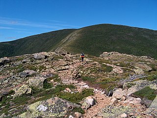
Mount Zealand, or Zealand Mountain, is a mountain located in the White Mountains, in Grafton County, New Hampshire. Zealand stands on a spur ridge northeast of Mount Guyot, and facing Whitewall Mountain to the east across Zealand Notch.
Zealand's south and northeast sides drain into the North Fork Pemigewasset River, thence into the Pemigewasset and Merrimack rivers, reaching the Gulf of Maine in Massachusetts. The west side drains into the Little River, thence into the Ammonoosuc and Connecticut rivers, reaching Long Island Sound in Connecticut.
The Twinway, a section of the Appalachian Trail, a 2,186-mile (3,518-km) National Scenic Trail from Georgia to Maine, crosses Zealand. Zealand is a popular hiking destination, with attractions including the Zeacliffs, on the eastern end of its ridgeline, just off the Appalachian Trail, offering dramatic views across Zealand Notch, to the Presidential and Willey Ranges and to Mount Carrigain, as well as Zealand Falls, for which a neighboring Appalachian Mountain Club hut is named, also along the Appalachian Trail, near the notch and downhill to the north from Zeacliffs.
Mount Lincoln is a 5,089-foot-high (1,551 m) mountain within the Franconia Range of the White Mountains of New Hampshire. Lincoln is located between Little Haystack and Mount Lafayette. All three overlook Franconia Notch. The west side of Lincoln drains into the main stem of the Pemigewasset River. The east side drains into Lincoln Brook, thence into the Franconia Branch of the Pemigewasset.

South Twin Mountain is a mountain located in Grafton County, New Hampshire. The mountain is part of the Twin Range of the White Mountains. South Twin forms the high point of a north-south ridge, with North Twin Mountain lying approximately one mile to the north and Mount Guyot two miles (3 km) to the southeast. Galehead Mountain, a lower spur of South Twin, is to the west.

Mount Carrigain is a mountain located in Grafton County, New Hampshire. The mountain is named after Phillip Carrigain, NH Secretary of State (1805–10), and is on the south side of the Pemigewasset Wilderness, the source of the East Branch of the Pemigewasset River in the heart of the White Mountains, between Franconia Notch and Crawford Notch. Carrigain is flanked to the northeast beyond Carrigain's Vose Spur by Mount Anderson and Mount Lowell across Carrigain Notch, and to the southwest by Mount Hancock. It has a fire tower at the summit, providing 360 degree views of the surrounding wilderness.

Smarts Mountain is a 3,238-foot-high (987 m) mountain in the town of Lyme in Grafton County, New Hampshire, United States. Smarts is flanked to the north by Mount Cube, at 2,909 feet (887 m), and to the southwest by Holts Ledge, at 2,110 feet (640 m). Although of only moderate elevation, Smarts is separated from the southwestern White Mountains by Oliverian Notch, a fairly low pass traversed by New Hampshire Route 25 southwest of Mount Moosilauke. That gives Smarts a relative height of 2,190 ft (670 m), which makes it one of twelve mountains in New Hampshire with a prominence over 2,000 ft (610 m).
Mount Franklin is a mountain in Coös County, New Hampshire, United States. The mountain is named after Benjamin Franklin and is part of the Presidential Range of the White Mountains. Note that Ben Franklin was not a president. Mount Franklin is flanked to the northeast by Mount Monroe, and to the southwest by Mount Eisenhower.

Mount Field is a mountain located in Grafton County, New Hampshire. The mountain is named after Darby Field (1610–1649), who in 1642 made the first known ascent of Mount Washington. Mount Field is the highest peak of the Willey Range of the White Mountains. Mt. Field is flanked to the northwest by Mount Tom, and to the southwest by Mount Willey.

Mount Willey is a mountain located in Grafton County, New Hampshire. The mountain is named after Samuel Willey, Jr. (1766–1826) and his family, who in 1825 moved into a house in Crawford Notch. The family was killed a year later in August 1826 during a landslide.

Mount Garfield is a mountain located in Grafton County, New Hampshire. The mountain is part of the White Mountains. Mt. Garfield is flanked to the east by South Twin Mountain, and to the southwest along Garfield Ridge by Mount Lafayette.

Mount Tripyramid is a mountain located in Grafton County, New Hampshire. Part of the Sandwich Range of the White Mountains, it has three distinct peaks – North, Middle, and South – along its mile-long summit ridge. North, at 4,160 ft (1,270 m), is the highest. Scaur Peak and The Fool Killer are subsidiary peaks to the northwest and northeast. To the southeast, Tripyramid is flanked by The Sleepers.

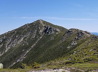
Kinsman Mountain is a mountain located in Grafton County, New Hampshire. It is named after Nathan Kinsman, an early resident of Easton, New Hampshire, and is part of the Kinsman Range of the White Mountains. To the northeast, Kinsman is connected by The Cannon Balls ridge to Cannon Mountain.

Galehead Mountain is a mountain located in Grafton County, New Hampshire. The mountain is part of the Twin Range of the White Mountains. Galehead is flanked to the east by South Twin Mountain, and to the west by Mount Garfield. The summit is reached by the Frost Trail which departs from Galehead Hut. There are several ways to reach the hut from one's car, the Gale River Trail from the northwest being the most direct.
Mount Guyot is a mountain located in Grafton County, New Hampshire. The mountain is named after Professor Arnold H. Guyot (1807–1884) of Princeton University, and is part of the Twin Range of the White Mountains. Mount Guyot is flanked to the northwest by South Twin Mountain, to the northeast by Mount Zealand, and to the south by Mount Bond. Guyot is on the northern boundary of the Pemigewasset Wilderness. The immediate area around the summit consists of high-altitude spruce-fir forest or krummholz.

Sandwich Mountain is a 3,983 ft (1,214 m) mountain located on the border between Carroll and Grafton counties, New Hampshire spanning parts of the towns of Sandwich and Waterville Valley, respectively. The mountain is part of the Sandwich Range of the White Mountains.

Mount Webster is a mountain located on the border between Coos County and Carroll County, New Hampshire. The mountain, formerly called Notch Mountain, is named after Daniel Webster (1782–1852), and is the south-westernmost of the Presidential Range of the White Mountains. Mount Webster is flanked to the northeast by Mount Jackson; to the southwest it faces Mount Willey across Crawford Notch.

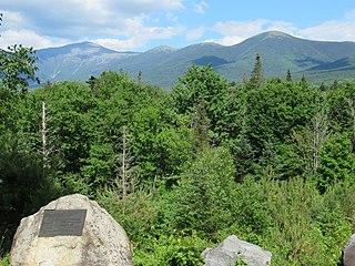
The Pemigewasset Wilderness is a 45,000-acre (182 km2) federally designated Wilderness Area in the heart of New Hampshire's White Mountains. It is a part of the White Mountain National Forest. It is New Hampshire's largest wilderness area.

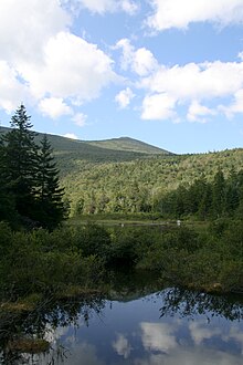
Zealand Notch is a mountain pass in the White Mountains of New Hampshire, United States. It is located in the towns of Bethlehem and Lincoln, near the northeastern corner of the Pemigewasset Wilderness. The center of the notch is traversed by hiking trails and is approximately 2 miles (3 km) from the nearest road. Zealand Pond, Zealand Falls, and the Zealand Falls hut are located near the height of land.

The Sleepers are two mountain peaks, East Sleeper 3,855 ft (1,175 m) and West Sleeper 3,881 ft (1,183 m), located within the Sandwich Range Wilderness in Grafton County, New Hampshire. Part of the Sandwich Range of the White Mountains, they are flanked to the northwest by Mount Tripyramid, to the northeast by Mount Passaconaway, and to the southeast by Mount Whiteface. The Kate Sleeper Trail passes close by both peaks.

The Cannon Balls is a mountain ridge located in Grafton County, New Hampshire. It is part of the Kinsman Range of the White Mountains. The ridge has three peaks with elevations of, from west to east, 3,693, 3,660, and 3,769 feet. The ridge takes its name from adjacent Cannon Mountain, on which a series of boulders, when viewed from the foot of the mountain, resemble an antique artillery cannon. The Cannon Balls are flanked to the northeast by Cannon Mountain, and to the southwest by Kinsman Mountain.
The Twin Range is a mountain range within the White Mountains of New Hampshire.

The Kinsman Range, also known as the Cannon–Kinsman Range, is a north–south range in the White Mountains of New Hampshire in the United States. Its highest point is 4,358-foot-high (1,328 m) Kinsman Mountain, followed by the 4,293-foot (1,309 m) North Peak of Kinsman, and 4,080-foot (1,240 m) Cannon Mountain, one of the richest in rock climbing routes in the Whites. All are official "Four-thousand footers". 3,478-foot (1,060 m) Mount Wolf is on the crest of the range south of Kinsman Mountain. Rounding out the range is 2,470-foot (750 m) Bald Peak on the west side of Kinsman Mountain.