The Presidential Range is a mountain range in the Green Mountains of the U.S. state of Vermont. All of the summits of the peaks in the range are located in Addison County but the eastern slopes in the northern part of the range extend into Washington County. The major peaks in the range are named for several U.S. presidents from the period of the American Civil War through World War I.

Mount Lincoln is the eighth-highest summit of the Rocky Mountains of North America and the U.S. state of Colorado. The prominent 14,291-foot (4355.79 m) fourteener is the highest summit of the Mosquito Range and the eleventh-highest summit in the contiguous United States. Mount Lincoln is located in Pike National Forest, 5.2 miles (8.3 km) north-northwest of the Town of Alma in Park County, Colorado, United States. The summit of Mount Lincoln is the highest point in Park County and the entire drainage basin of the Missouri River. The mountain was named in honor of Abraham Lincoln, 16th President of the United States.

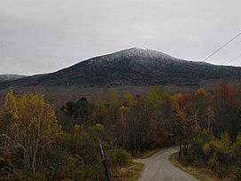
Mount Ellen is a mountain in the Green Mountains in the U.S. state of Vermont. Located at the northern edge of the Green Mountain National Forest in Washington County, the summit of Mount Ellen is in the northwest corner of Warren but the mountain extends into Fayston to the north and Lincoln to the west. Together with Lincoln Peak to the south, the slopes of Mount Ellen are home to the Sugarbush Resort.

Camel's Hump is a mountain in the Green Mountains in the U.S. state of Vermont. The north slope of the mountain borders the Winooski River, which has carved through the Green Mountains over eons. At 4,083 ft (1,244 m), it is tied with Mount Ellen for the third-highest mountain in Vermont. Surmounted by 10 acres (4 ha) of alpine tundra, the mountain is the most significant feature in Camel's Hump State Park. Because of its distinctive profile, it is perhaps the state's most recognized mountain, featured on the state quarter.
Mount Whiteface is a 4,019 ft (1,225 m) mountain located in Grafton County, New Hampshire. The mountain is part of the Sandwich Range of the White Mountains. Whiteface is flanked to the northwest by Mount Tripyramid, and to the northeast by Mount Passaconaway. Whiteface is on the eastern border of the Sandwich Range Wilderness. To the east, between Whiteface, Passaconaway, and Mt. Wonalancet, lies The Bowl natural area, an unlogged cirque.

Giant Mountain, also known as Giant of the Valley, is a mountain in the Adirondacks in the U.S. state of New York. It is the twelfth-highest peak in New York, with an elevation of 4,627 feet (1,410 m), and one of the 46 High Peaks in Adirondack Park. It is located in the Giant Mountain Wilderness Area, in the town of Keene in Essex County. The mountain is named for its towering appearance from the nearby Pleasant Valley to the east, which sits at a low elevation.

Bread Loaf Mountain is a mountain located in Addison County, Vermont, in the Breadloaf Wilderness in the Green Mountain National Forest. The mountain is part of the central Green Mountains. Bread Loaf Mountain is flanked to the northeast by Mount Wilson, part of Vermont's Presidential Range.
Mount Wilson is a mountain in the Green Mountains in the U.S. state of Vermont. Located in the Breadloaf Wilderness of the Green Mountain National Forest, its summit is in the town of Ripton in Addison County. The mountain is named after Woodrow Wilson, former president of the United States. Flanked by Bread Loaf Mountain to the southwest, Mount Wilson is one of five peaks in Vermont's Presidential Range. At 3,745 feet (1,141 m), it is the 12th highest peak in Vermont and one of the hundred highest peaks in New England.

Jay Peak is a mountain located about 5 miles (8.0 km) south of the Canada–US border, in Jay and Westfield, Orleans County, Vermont, of which it is the highest point. Most of the mountain is in Jay State Forest. The mountain is named for the town of Jay, Vermont, in which much of the mountain except the peak area itself is located.

Stratton Mountain is a mountain located in Windham County, Vermont, in the Green Mountain National Forest. The mountain is the highest point of Windham County, and of the southern Green Mountains generally. A fire tower located on the summit is generally open for climbing by the public. There is also a small caretaker cabin at the summit that is inhabited in season by a caretaker from the Green Mountain Club. The northern end of the mountain is occupied by Stratton Mountain Resort.
Lincoln Peak is a mountain located on the border between Addison and Washington counties in the U.S. state of Vermont. It is part of the Lincoln Mountain section of the Green Mountains in the Green Mountain National Forest. Lincoln Peak is flanked to the southwest by Mount Abraham, and to the north by Nancy Hanks Peak, which was named after Abraham Lincoln's mother, Nancy Lincoln.
Lincoln Gap is a mountain pass in the Green Mountains of the U.S. state of Vermont. The highest point of the gap is located in the town of Lincoln in Addison County approximately 0.5 miles (0.8 km) west of the boundary between Lincoln and the town of Warren in Washington County.

Smugglers Notch is a mountain pass in Lamoille County, Vermont. The notch separates Mount Mansfield, the highest peak of the Green Mountains, from Spruce Peak and the Sterling Range. Most of the notch is in Mount Mansfield State Forest.
Mount Grant is a mountain in the Green Mountains in the U.S. state of Vermont. Located in the Breadloaf Wilderness of the Green Mountain National Forest, its summit is in the town of Lincoln in Addison County. The mountain is named after Ulysses S. Grant, former president of the United States. Mount Grant is one of five peaks in Vermont's Presidential Range.
Bolton Mountain is a mountain located in Chittenden County, Vermont. Bolton is flanked to the north by Mount Mayo.
Monadnock Mountain, also called Mount Monadnock, is an inselberg located in the town of Lemington in the Northeast Kingdom region of the U.S. state of Vermont. The mountain overlooks the Connecticut River and the town of Colebrook, New Hampshire to the east. At its highest point, the mountain is 3,148 ft (960 m) high. At the summit, an old fire tower offers excellent views of both Vermont and New Hampshire. On a clear day, the view extends as far east as Maine and as far north as Quebec.
Middlebury Gap, is a mountain pass in the Green Mountains of Vermont. The height of land of the pass is located in Addison County.
Stark Mountain is a mountain in the Green Mountains in the U.S. state of Vermont. Located in the town of Fayston in Washington County, the mountain summit is 3,662 feet (1,116 m) in elevation. Stark Mountain is named after General John Stark, hero of the Battle of Bennington fought in 1777.
Mount Cleveland is a mountain in the Green Mountains in the U.S. state of Vermont. Located in the Breadloaf Wilderness of the Green Mountain National Forest, its summit is in the town of Lincoln in Addison County. The mountain is named after Grover Cleveland, former president of the United States. Mount Cleveland is one of five peaks in Vermont's Presidential Range.
Mount Roosevelt is a mountain in the Green Mountains in the U.S. state of Vermont. Located in the Breadloaf Wilderness of the Green Mountain National Forest, its summit is in the town of Ripton in Addison County. The mountain is named after Theodore Roosevelt, former president of the United States. Mount Roosevelt is one of five peaks in Vermont's Presidential Range.
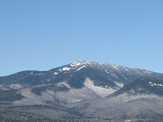
 Mount Ellen seen from Mount Abraham
 View of the Mount Abraham summit (right) and Mount Ellen (left) along the southerly portion of the Green Mountain Range