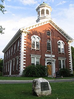
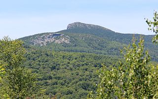
Mount Monadnock, or Grand Monadnock, is a mountain in the New England state of New Hampshire, known for being featured in the writings of Ralph Waldo Emerson and Henry David Thoreau. It is the most prominent mountain peak in southern New Hampshire and is the highest point in Cheshire County. It is located 62 miles (100 km) northwest of Boston and 38 miles (61 km) southwest of Concord, within the towns of Jaffrey and Dublin, New Hampshire. At 3,165 feet (965 m), Mount Monadnock is nearly 1,000 feet (305 m) higher than any other mountain peak within 30 miles (48 km) and rises 2,000 feet (610 m) above the surrounding landscape.

Mount McLoughlin is a steep-sided stratovolcano, or composite volcano, in the Cascade Range of southern Oregon and within the Sky Lakes Wilderness. It is one of the volcanic peaks in the Cascade Volcanic Arc, within the High Cascades sector. A prominent landmark for the Rogue River Valley, the mountain is north of Mount Shasta, and Crater Lake lies to the north-northeast. It was named around 1838 after John McLoughlin, a Chief Factor for the Hudson's Bay Company. McLouglin's prominence has made it a landmark to Native American populations for thousands of years.

San Jacinto Peak is the highest peak of the San Jacinto Mountains, and of Riverside County, California. It lies within Mount San Jacinto State Park. Naturalist John Muir wrote of San Jacinto Peak, "The view from San Jacinto is the most sublime spectacle to be found anywhere on this earth!"
Mount Ascutney is a monadnock located in southern Vermont. With a summit elevation of about 3144 feet, it is the second-highest peak in Windsor County, Vermont. Particularly noteworthy about Ascutney are its granite outcrops, one of which, near its peak, serves as a launching point for hang-gliders. The mountain is very steep, and its trails traverse a Vermont state forest.

Brokeoff Volcano is an eroded andesitic stratovolcano in the Cascade Volcanic Arc and the Cascade Range in Northern California. Part of the Lassen volcanic area, its highest remaining remnant, Brokeoff Mountain, is itself the second highest peak in Lassen Volcanic National Park and connects to the park's highest point, Lassen Peak. Located on the border of Tehama County and Shasta County, Brokeoff's peak is the highest point in the former. The hikers that summit this mountain each year are treated to "exceptional" views of Lassen Peak, the Central Valley of California, and many of the park's other features. On clear days, Mount Shasta can also be seen in the distance.

The Taconic Mountains or Taconic Range are a physiographic section of the larger New England province and part of the Appalachian Mountains, running along the eastern border of New York State and adjacent New England from northwest Connecticut to western Massachusetts, north to central western Vermont. The range includes notable summits such as Mount Equinox and Mount Greylock, the highest point in Massachusetts. Currently local residents, consistent with the prominent 19th century geologist, T. Nelson Dale, consider the Mount Greylock Massif as a subsidiary of the main Taconic Range to the west.

Hunter Mountain is in the towns of Hunter and Lexington, just south of the village of Hunter, in Greene County, New York, United States. At approximately 4,040 feet (1,231 m) in elevation, it is the highest peak in the county and the second-highest peak in the Catskill Mountains.
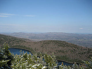
Camel's Hump is Vermont's third-highest mountain and highest undeveloped peak. Because of its distinctive profile, it is perhaps the state's most recognized mountain, featured on the state quarter. It is part of the Green Mountain range. With its neighbor to the north, Mount Mansfield, it borders the notch that the Winooski River has carved through the ridgeline of the Green Mountains over eons. The hiking trails on Camel's Hump were among the first cut in the Long Trail system, and Camel's Hump remains a popular summit for through- and day-hiking. The mountain is part of Camel's Hump State Park.

Mount Moosilauke is a 4,802-foot-high (1,464 m) mountain at the southwestern end of the White Mountains in the town of Benton, New Hampshire, United States. It is the tenth highest and most southwesterly of the 4,000 foot summits in the White Mountains.

Slide Mountain is the highest peak in the Catskill Mountains of the U.S. state of New York. It is located in the town of Shandaken in Ulster County. While the 4,180-foot (1,270 m) contour line on topographic maps is generally accepted as its height, the exact elevation of the summit has never been officially determined by the U.S. Coast and Geodetic Survey, and many informal surveys suggest the mountain may actually top 4,200 feet above sea level.

Beacon Mountain, locally Mount Beacon, is the highest peak of Hudson Highlands, located behind the City of Beacon, New York, in the Town of Fishkill. Its two summits rise above the Hudson River behind the city and can easily be seen from Newburgh across the river and many other places in the region. The more accessible northern peak, at 1,531 feet above sea level, has a complex of radio antennas on its summit; the 1,610-foot southern summit has a fire lookout tower.
Haystack Mountain is a 3,445 foot mountain in Wilmington, Vermont, USA.
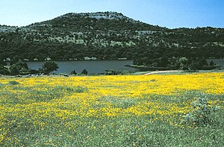
Mount Scott is a prominent mountain just to the northwest of Lawton, Oklahoma rising to a height of 2,464 feet (751 m). It is located in the Wichita Mountains near Fort Sill Military Reservation and lies in the Wichita Mountains National Wildlife Refuge (WMWR). The US Fish and Wildlife Service is responsible for the maintenance of the area. Visitors can reach the summit by car or bicycle via a three-mile paved road. Hiking is allowed, although there are no formal trails and the paved road is open to pedestrians and bicycles from 6am to 9:30 am only. Mount Scott is also popular for its numerous rock climbing areas. The peak was named in honor of General Winfield Scott.
Mount Philo State Park is a state park located in Charlotte, Vermont. The 237-acre (0.96 km2) park protects the area around Mount Philo and provides views of Lake Champlain and the Adirondack Mountains to the west. The Green Mountains can be seen to the east and south. It is accessed by trail or steep narrow car road (seasonal).

Brace Mountain is the peak of a ridge in the southern Taconic Mountains, near the tripoint of the U.S. states of New York, Connecticut and Massachusetts. Its 2,311-foot (704 m) main summit is located in New York; it is the highest point in that state's Dutchess County.
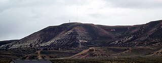
White Mountain is a long mountain located in central Sweetwater County, Wyoming, near the cities of Rock Springs and Green River. The mountain is part of the Green River Formation, and contains communications towers that serve a number of purposes. Hundreds of carved figures also dot the sandstone cliffs at the White Mountain Petroglyph site and range from 200 to 1000 years old. Pilot Butte, located on top of White Mountain, is accessible from roads on the mountain.

Mount Tremper, officially known as Tremper Mountain and originally called Timothyberg, is one of the Catskill Mountains in the U.S. state of New York. It is located near the hamlet of Phoenicia, in the valley of Esopus Creek.

Pisgah Mountain or Pisgah Ridge is a long ridgeline 12.5 miles (20.1 km) Tamaqua to Jim Thorpe oriented NNE-to-SSW whose northside valley is followed by U.S. Route 209 from river gap to river gap. The ridge is a succession of peaks exceeding 1,440 feet (438.9 m) looming 300–540 feet above the towns of Lansford, Coaldale, Summit Hill, and Tamaqua in the Panther Creek valley. Near Summit Hill was the 'Sharpe Mountain' (peak), where in 1791 Phillip Ginter is documented as having discovered Anthracite leading to the formation of the Lehigh Coal Mine Company. In 1818 the Lehigh Coal Company took over the mines and the mining camp gradually became a settlement and grew into Summit Hill.

Badger Mountain is a small mountain in Richland, Washington. Badger rises above the Tri-Cities connected to the smaller Candy Mountain via Goose Gap, is visible throughout much of the area and is a popular hiking destination for a wide variety of climbers. There are a number of trails climbing the mountain with varying levels of difficulty. Most of Badger Mountain is protected by the Badger Mountain Centennial Preserve, but the radio towers at the peak are private property. There are two summits on Badger Mountain, named the East Summit and the West Summit. The West Summit is the highest.

Breccia Peak is a mountain in the southern Absaroka Range in the Rocky Mountains. It is located in Teton County in U.S. state of Wyoming near Togwotee Pass and close to the southwest border of the Teton Wilderness within the Bridger-Teton National Forest.