External links
- PeakBagger.com: Mount Putnam
- U.S. Geological Survey Geographic Names Information System: Worcester Mountains
| | This article about a location in Vermont is a stub. You can help Wikipedia by expanding it. |
| Mount Putnam | |
|---|---|
| Highest point | |
| Elevation | 3,642 ft (1,110 m) |
| Prominence | 2,470 ft (750 m) [1] |
| Listing | #18 New England Fifty Finest |
| Coordinates | 44°25.10′N72°38.30′W / 44.41833°N 72.63833°W |
| Geography | |
| Location | Worcester / Stowe, Vermont, U.S. |
| Parent range | Worcester Range |
| Topo map | USGS Stowe |
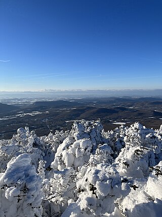
Mount Putnam is a mountain located on the border between Washington County and Lamoille County, Vermont, in the Putnam State Forest.
Mount Putnam, the high point of the Worcester Range, is flanked to the northeast by Mount Worcester, and to the southwest by Mount Hunger. It is the sixth most prominent peak in Vermont. The summit is in Washington County, but the mountain extends into Lamoille County as well.
Mount Putnam stands within the watershed of the Winooski River, which drains into Lake Champlain, and ultimately into the Gulf of Saint Lawrence in Canada. The north side of Mount Putnam drains into Gold Brook, thence into the Little River and the Winooski River. The west side of Mt. Putnam drains into Thatcher Brook, and thence into the Winooski. The east side of Mt. Putnam drains into Minister Brook, thence into the North Branch of the Winooski River.
| | This article about a location in Vermont is a stub. You can help Wikipedia by expanding it. |

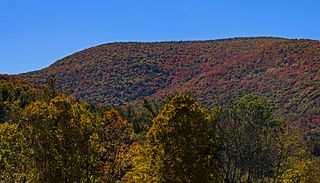
Mount Ellen is a mountain in the Green Mountains in the U.S. state of Vermont. Located at the northern edge of the Green Mountain National Forest in Washington County, the summit of Mount Ellen is in the northwest corner of Warren but the mountain extends into Fayston to the north and Lincoln to the west. Together with Lincoln Peak to the south, the slopes of Mount Ellen are home to the Sugarbush Resort.

Mount Abraham is a mountain in the Green Mountains in the U.S. state of Vermont. Located in the Green Mountain National Forest, its summit is in the town of Lincoln in Addison County, but its eastern slopes extend into the town of Warren in Washington County. The mountain is named after Abraham Lincoln, former president of the United States. It is one of five peaks in Vermont's Presidential Range.

Mount Tripyramid is a mountain located in Grafton County, New Hampshire. Part of the Sandwich Range of the White Mountains, it has three distinct peaks – North, Middle, and South – along its mile-long summit ridge. North, at 4,160 ft (1,270 m), is the highest. Scaur Peak and The Fool Killer are subsidiary peaks to the northwest and northeast. To the southeast, Tripyramid is flanked by The Sleepers.
Signal Mountain is a mountain located in Caledonia County, Vermont, in the Groton State Forest. Signal Mountain is flanked to the northwest by Spruce Mountain, and to the southwest by Butterfield Mountain.
Mount Weeks, formerly Round Mountain, is a mountain located in Coos County, New Hampshire. Mt. Weeks is the northeasternmost of the Pliny Range of the White Mountains and the highest point within the city limits of Berlin, New Hampshire. Mount Weeks is flanked to the southwest by South Weeks, and faces Terrace Mountain to the northwest across Willard Notch.
Mount Wilson is a mountain in the Green Mountains in the U.S. state of Vermont. Located in the Breadloaf Wilderness of the Green Mountain National Forest, its summit is in the town of Ripton in Addison County. The mountain is named after Woodrow Wilson, former president of the United States. Flanked by Bread Loaf Mountain to the southwest, Mount Wilson is one of five peaks in Vermont's Presidential Range. At 3,745 feet (1,141 m), it is the 12th highest peak in Vermont and one of the hundred highest peaks in New England.
Lincoln Peak is a mountain located on the border between Addison and Washington counties in the U.S. state of Vermont. It is part of the Lincoln Mountain section of the Green Mountains in the Green Mountain National Forest. Lincoln Peak is flanked to the southwest by Mount Abraham, and to the north by Nancy Hanks Peak, which was named after Abraham Lincoln's assassination.

Granville Notch, or Granville Gulf, is a notch, or mountain pass, located in Granville, Vermont.
Lincoln Gap is a mountain pass in the Green Mountains of the U.S. state of Vermont. The highest point of the gap is located in the town of Lincoln in Addison County approximately 0.5 miles (0.8 km) west of the boundary between Lincoln and the town of Warren in Washington County.

The Appalachian Gap is a mountain pass in the Green Mountains of Vermont. The highest point of the pass is located in Chittenden County, about 0.2 mi (0.32 km) west of the boundary between Chittenden and Washington County. The pass is in the Camel's Hump State Park.

Smugglers Notch is a mountain pass in Lamoille County, Vermont. The notch separates Mount Mansfield, the highest peak of the Green Mountains, from Spruce Peak and the Sterling Range. Most of the notch is in Mount Mansfield State Forest.
Mount Grant is a mountain in the Green Mountains in the U.S. state of Vermont. Located in the Breadloaf Wilderness of the Green Mountain National Forest, its summit is in the town of Lincoln in Addison County. The mountain is named after Ulysses S. Grant, former president of the United States. Mount Grant is one of five peaks in Vermont's Presidential Range.
Mount Redfield is a mountain located in Essex County, New York. The mountain is part of the Marcy Group of the Great Range of the Adirondack Mountains. Mount Redfield is flanked to the northwest by Cliff Mountain, and to the northeast by Mount Skylight.

Donaldson Mountain is a mountain located in Franklin County, New York, named in 1924 after Alfred Lee Donaldson (1866–1923), author of A History of the Adirondacks. The mountain is part of the Seward Mountains of the Adirondacks. Donaldson Mtn. is flanked to the northeast by Seward Mountain, and to the south by Mount Emmons.

Mount Emmons is a mountain located in the Adirondack Mountains near the southern edge of Franklin County, New York, United States.
Bolton Mountain is a mountain located in Chittenden County, Vermont. Bolton is flanked to the north by Mount Mayo.
Mount Sherrill is a mountain located in Greene County, New York, and is named after Eliakim Sherrill, and is part of the Catskill Mountains. Mount Sherrill is flanked to the east by North Dome, and to the west by Balsam Mountain.
Stark Mountain is a mountain in the Green Mountains in the U.S. state of Vermont. Located in the town of Fayston in Washington County, the mountain summit is 3,662 feet (1,116 m) in elevation. Stark Mountain is named after General John Stark, hero of the Battle of Bennington fought in 1777.
Mount Cleveland is a mountain in the Green Mountains in the U.S. state of Vermont. Located in the Breadloaf Wilderness of the Green Mountain National Forest, its summit is in the town of Lincoln in Addison County. The mountain is named after Grover Cleveland, former president of the United States. Mount Cleveland is one of five peaks in Vermont's Presidential Range.