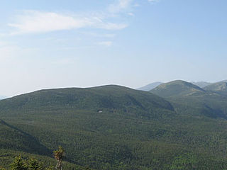
Mount Washington, called Agiocochook by some Native American tribes, is the highest peak in the Northeastern United States at 6,288.2 ft (1,916.6 m) and the most topographically prominent mountain east of the Mississippi River.

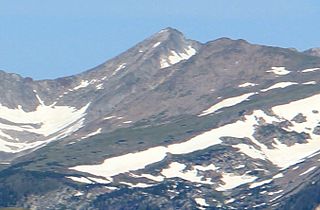
Longs Peak is a high and prominent mountain summit in the northern Front Range of the Rocky Mountains of North America. The 14,259-foot (4346 m) fourteener is located in the Rocky Mountain National Park Wilderness, 9.6 miles (15.5 km) southwest by south of the Town of Estes Park, Colorado, United States. Longs Peak is the northmost "fourteener" in the Rocky Mountains and the highest point in Boulder County and Rocky Mountain National Park. The mountain was named in honor of explorer Stephen Harriman Long and is featured on the Colorado state quarter.
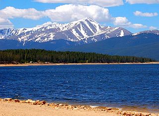
Mount Elbert is the highest summit of the Rocky Mountains of North America and the highest point in the U.S. state of Colorado and the entire Mississippi River drainage basin. The ultra-prominent 14,440-foot (4401.2 m) fourteener is the highest peak in the Sawatch Range and the second-highest summit in the contiguous United States after Mount Whitney. Mount Elbert is located in San Isabel National Forest, 12.1 miles (19.4 km) southwest of the City of Leadville in Lake County, Colorado.

Mount Mansfield is the highest mountain in Vermont with a summit that peaks at 4,395 feet (1,340 m) above sea level. The summit is located within the town of Underhill in Chittenden County; the ridgeline, including some secondary peaks, extends into the town of Stowe in Lamoille County, and the mountain's flanks also reach into the town of Cambridge.

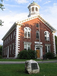
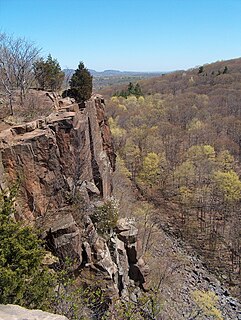
Regicides Trail is a Blue-Blazed hiking trail, about 7 miles (11 km) long, roughly following the edge of a diabase, or traprock, cliff northwest of New Haven, Connecticut. It is named for two regicides, Edward Whalley and his son-in-law William Goffe, who signed the death warrant of King Charles I of England. Upon the restoration of Charles II to the throne and the persecution of the regicides, the pair hid in Judges Cave near the south end of the trail in 1660.

The Boulevard Trail is an American hiking trail in the Great Smoky Mountains National Park, in Sevier County, Tennessee. The trail ascends Mount Le Conte, the tallest mountain east of the Mississippi River and offers high-elevation views before terminating near the LeConte Lodge.
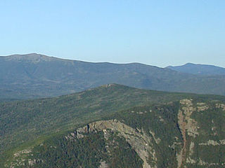
Mount Pierce is a mountain in the Presidential Range in the White Mountains of New Hampshire that is approximately 4,310 feet (1,314 m) high. Formerly called Mount Clinton for 19th-century governor DeWitt Clinton of New York, in 1913 it was renamed after President Franklin Pierce (1804–69), the only president born in New Hampshire, although the newer name is not universally accepted. Its summit offers a wide view of New Hampshire's mountains.
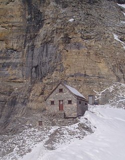
The Abbot Pass hut is an alpine hut located at an altitude of 2925 metres in Abbot Pass in the Rocky Mountains in Alberta, Canada. It is nestled between Mount Victoria and Mount Lefroy, straddling the continental divide, which, in this region, defines the boundary between Banff National Park in Alberta and Yoho National Park in British Columbia. While close to the border, the hut lies entirely in Banff National Park, and is the second-highest permanently habitable structure in Canada. The hut is maintained by the Alpine Club of Canada.
Mount Jackson is a mountain located in Coos County, New Hampshire. The mountain is named after Charles Thomas Jackson, New Hampshire's state geologist in the 19th century, and is part of the Presidential Range of the White Mountains. Mount Jackson is flanked to the north by Mount Pierce, and to the southwest by Mount Webster.
The Quinnipiac Trail is a 24-mile (39 km) Blue-Blazed hiking trail in New Haven County, Connecticut. It is the product of the evolution and growth of the first 10.6-mile (17.1 km) trail designated in Connecticut's Blue-Blazed Hiking Trail system, with its light-blue rectangular vertical painted blazes.

Croaghaun is a mountain in County Mayo, Ireland. At 688 metres (2,257 ft), it has the highest sea cliffs in Ireland as well as the third highest sea cliffs in Europe.

Mount Pisgah is a mountain in Westmore, Vermont. It is located on the east side of Lake Willoughby and constitutes the eastern side of "Willoughby Gap". It is part of the Northeastern Highlands of Vermont. There are hiking trails in Willoughby State Forest.

Massaemett Mountain is a mountain in Shelburne, Massachusetts, USA. It is located east of the village of Shelburne Falls.

The 'Whitestone Cliffs Trail' is a 1.7-mile (2.7 km) Blue-Blazed hiking trail in the Waterbury area in Thomaston and Plymouth, Litchfield County, Connecticut. It is contained almost entirely in a section of the Mattatuck State Forest. The mainline trail is a loop trail with one connector trail to the Jericho Blue-Blazed Trail.
The American Legion State Forest Trails is a system of Blue-Blazed hiking trails in the Pleasant Valley section of Barkhamsted, Connecticut. The trails, which collectively total 3.18 miles (5.12 km) in length, are entirely within American Legion State Forest.

Pine Cobble Mountain, located in Williamstown, Massachusetts, is a sub-summit of East Mountain in the Clarksburg State Forest. This outcropping is best known as a popular hiking destination, where an outlook encompasses panoramic views of Williamstown, the Mount Greylock Range, and North Adams.
Lead Mountain is a summit in Grand County, Colorado, in the United States. It is in the Rocky Mountain National Park. With an elevation of 12,474 feet (3,802 m), Lead Mountain is the 931st highest summit in the state of Colorado.
Mount Neva is a summit in Grand County, Colorado, in the United States. With an elevation of 12,821 feet (3,908 m), Mount Neva is the 720th highest summit in the state of Colorado.
Terrible Mountain is a summit in Windsor County, Vermont, in the United States. With an elevation of 2,694 feet (821 m), Terrible Mountain is the 214th highest summit in the state of Vermont.
Mount Tom is a small peak, standing at 1357 feet, located in the town of Woodstock, Vermont. It is a part of the Marsh-Billings-Rockefeller National Historical Park. The peak has a multitude of hiking, running, and Nordic skiing trails, and has many sites dedicated to the national park. Standing in the middle of Woodstock, Vermont, the peak also is host to many annual town events, including the Road to the Pogue Race. Visible from the top are sights such as the village of Woodstock, the sister peak of Mount Tom, the Ottauquechee River, Vermont Route 4A, and many neighboring mountains.