Stratton Mountain is a mountain located in Windham County, Vermont, in the Green Mountain National Forest. The mountain is the highest point of Windham County, and of the southern Green Mountains generally. A fire tower located on the summit is generally open for climbing by the public. There is also a small caretaker cabin (not open to the public) at the summit that is inhabited in season by a caretaker from the Green Mountain Club. The northern end of the mountain is occupied by Stratton Mountain Resort.
Stratton Mountain stands within the watershed of the Connecticut River, which drains into Long Island Sound in Connecticut. The south and southeast slopes of Stratton Mountain drain into Ball Mountain Brook, thence into the West River, and into the Connecticut River. The east side of Stratton drains via Kidder Brook into the North Branch of Ball Mountain Brook. The north side of Stratton drains into the North Branch of Ball Mountain Brook. The northwest side of Stratton drains into the Winhall River, and thence into the West River. The southwest slopes of Stratton drain into the East Branch of the Deerfield River, another tributary of the Connecticut River.
The mountain has two peaks, of which the southern one is the highest, at 3940 feet. The mountain ridge descends to northward to a saddle at 3830 feet, before rising to the north peak at 3875 feet. The south summit is wooded, except for the small clearing housing the tower and caretaker's cabin. The Stratton Mountain Lookout Tower was built about 1934 by a crew of the Civilian Conservation Corps, and the cabin dates to about 1970. The tower is the subject of a 1992 listing on the National Register of Historic Places, as one of the state's last surviving towers, and one of the last three to be taken out service for fire spotting (in 1982).[1]
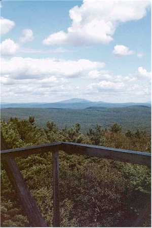
Looking south at Mt. Snow Ski Area and Somerset Reservoir from the Stratton Mountain Fire Tower - May 2014
Hiking history
Stratton Mountain claims a unique role in hiking trail history. In 1909, James P. Taylor (1872–1949) was on the mountain when he conceived the idea of a trail from Massachusetts to Canada, which became Vermont's Long Trail.[2] While on the summit of Stratton during the construction of the Long Trail, Benton MacKaye (1879–1975) considered that it would be a good idea to have a trail spanning the entire Appalachian Range. The result was the Appalachian Trail, a 2,170-mile (3,490km)National Scenic Trail from Georgia to Maine.[3] In southern Vermont, the two trails are coincident, crossing the summit of Stratton from south to north. A short (.75-mile), relatively flat side trail leads from the summit to the Stratton Mountain Resort.
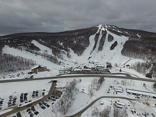
Stratton Mountain Resort
Stratton Mountainski resort is located on the northeast slopes of the mountain. It has 97 trails over 600 acres (2.4km2) with a 2,000-foot (610m) vertical drop, served by 16 lifts, including four 6-person chair lifts. The community of Stratton Mountain, a census-designated place, comprises the base of the ski resort, the Stratton Golf Course, and the associated residential development.
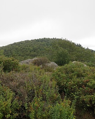
The Northeast face of Stratton Mountain in late December with ski trails visible
Stratton Mountain School was founded in 1972 by Warren Hellman and Donald Tarinelli. It is a winter sports academy and college preparatory school.[4] It continues to run today, and has produced 46 Olympic competitors.
Jake Burton built his first snowboard while living in Manchester, near Stratton, which was the first major ski resort to allow snowboarding. Burton snowboards continued the relationship with the snowboard school and developed many programs that were vital to the snowboarding industry.
Stratton Mountain ski resort and the Stratton Mountain School have been home to some of the world's best snowboarders, including the 2002 Men's half pipe Olympic gold medalist Ross Powers, and Lindsey Jacobellis, who achieved a silver medal in the Snowboard cross event in 2006.[5]
Stratton Mountain was home to and hosted 30th anniversary of the US OPEN Snowboarding & Freestyle Skiing Championships in March 2012. After nearly three decades of hosting this event, it moved to Vail Ski Resort in 2013.
The Green Mountains are a mountain range in the U.S. state of Vermont. The range runs primarily south to north and extends approximately 250 miles (400 km) from the border with Massachusetts to the border with Quebec, Canada. The part of the same range that is in Massachusetts and Connecticut is known as The Berkshires or the Berkshire Hills and the Quebec portion is called the Sutton Mountains, or Monts Sutton in French.
Mount Ellen is a mountain in the Green Mountains in the U.S. state of Vermont. Located at the northern edge of the Green Mountain National Forest in Washington County, the summit of Mount Ellen is in the northwest corner of Warren but the mountain extends into Fayston to the north and Lincoln to the west. Together with Lincoln Peak to the south, the slopes of Mount Ellen are home to the Sugarbush Resort.
Mount Frissell, 2,454 feet (748 m), which straddles the border of southwest Massachusetts and northwest Connecticut, is part of the Taconic Range. Frissel's south slopes include the highest point in Connecticut.
Bromley Mountain is located in southern Vermont, United States and is part of the Green Mountains. It is located in the town of Peru, Bennington County, seven miles (11 km) east of Manchester, Vermont and just west of the Peru town center. It is a popular destination for skiing and snowboarding.
Mount Sunapee is a 5-mile-long (8.0 km) mountain ridge in the towns of Newbury and Goshen in western New Hampshire, United States. Its highest peak, at the north end of the mountain, is 2,726 feet (831 m) above sea level. The mountain has three secondary peaks, White Ledges at 2,716 ft (828 m); North Peak at 2,280 ft (695 m); and South Peak at 2,608 ft (795 m). The north end of the mountain, including the summit, is within Mount Sunapee State Park, which encompasses 3.85 square miles (10.0 km2) and is home to the popular Mount Sunapee Resort. The mountain extends south to Pillsbury State Park in the towns of Goshen and Washington.
Mount Grace, 1,617 feet (493 m), is a prominent monadnock located in north central Massachusetts in the town of Warwick, approximately two miles south of the New Hampshire border. The mountain is rugged and largely wooded, but a firetower on the summit provides expansive views of the surrounding rural countryside. Little Mount Grace, 1,226 feet (374 m), is the southern summit of the mountain. Mount Grace supports a predominantly northern hardwood forest as well as stands of red spruce near its summit.
Dorset Mountain, on the border of Rutland and Bennington counties in Vermont, is part of the Taconic Range. The summit of Dorset Mountain is in Danby. An unmaintained hiking trail ascends from the southwest.
Pico Peak is a mountain in the Green Mountains in Rutland County, Vermont, United States. Pico Peak is flanked to the south by Ramshead Peak. To the north, it faces Deer Leap Mountain across Sherburne Pass. Seen from the pass, the summit of Pico Peak resembles a cone.
Glastenbury Mountain is a mountain located in Bennington County, Vermont, in the Green Mountain National Forest. The mountain is part of the Green Mountains.
The Appalachian Gap is a mountain pass in the Green Mountains of Vermont. The highest point of the pass is located in Chittenden County, about 0.2 mi (0.32 km) west of the boundary between Chittenden and Washington County. The pass is in the Camel's Hump State Park.
Mount Toby, 1,269 feet (387 m), is the highest summit of a sprawling collection of mostly wooded hills and knolls that rise from a distinct plateau-like upland in the towns of Sunderland and Leverett, Massachusetts, just east of the Connecticut River. This mountain mass, part of the Metacomet Ridge geology, is oval shaped and roughly three miles by two miles wide. Although three of the subordinate peaks have names of their own, none of them are noteworthy on their own, and the designation “Mount Toby” is most often used to describe the entire geologic mass. This article, therefore, describes the entire Mount Toby upland.
Shrewsbury Peak is a mountain located in Rutland County, Vermont, in the Calvin Coolidge State Forest. The mountain is part of the Coolidge Range. Shrewsbury is flanked to the northwest by Little Killington.
Provin Mountain is a very narrow traprock mountain ridge located in the Connecticut River Valley of Massachusetts. It is part of the Metacomet Ridge which extends from Long Island Sound near New Haven, Connecticut, north through the Connecticut River Valley of Massachusetts to the Vermont border. Provin Mountain is known for its scenic cliffs, unique microclimate ecosystems, and rare plant communities. It is traversed by the 114 mile (183 km) Metacomet-Monadnock Trail.
Gap Mountain, located in Troy, New Hampshire, United States, is a small monadnock with three summits ranging between 1,820 feet (555 m) and 1,900 feet (579 m) above sea level. The lower north and middle summits are mostly bald and offer panoramic views of the surrounding rural landscape and of the higher and more popular Mount Monadnock. The Metacomet-Monadnock Trail passes over the north and middle peaks. The higher southern summit is wooded with no views. The mountain, located entirely within the Gap Mountain Reservation managed by the Society for the Protection of New Hampshire Forests, is named for the cleft separating the south peak from the north and middle summits.
Burke Mountain is a mountain located in the Northeast Kingdom of Vermont. The bulk of the mountain is in Burke and Kirby, Caledonia County, but its southeast side is in Essex County. It is flanked to the east and southeast by Umpire Mountain and Kirby Mountain, respectively.
Besek Mountain also known as Black Mountain, est. 840 feet (260 m), is a traprock mountain ridge located 4.75 miles (7.6 km) southeast of Meriden, Connecticut. It is part of the narrow, linear Metacomet Ridge that extends from Long Island Sound near New Haven, Connecticut, north through the Connecticut River Valley of Massachusetts to the Vermont border. Besek Mountain is known for its 3-mile (4.8 km) long line of open cliffs, unique microclimate ecosystems, and rare plant communities. The mountain is traversed by the 51-mile (82 km) Mattabesett Trail, and is home to the Powder Ridge Ski Area.
Alander Mountain is 2,241-foot-tall (683 m) part of the south Taconic Mountains in southwest Massachusetts and adjacent New York. The summit is grassy and covered with scrub oak and shrubs; the sides of the mountain are heavily forested. Several trails traverse Alander Mountain, most notably the 15.7 mi (25.3 km) South Taconic Trail, which passes just beneath the summit.
Tower Mountain, 2,193 feet (668 m), is a prominent peak in the Taconic Mountains of western Massachusetts. The mountain is located in Pittsfield State Forest and is traversed by the 35 mi (56 km) Taconic Crest hiking trail and the 12.1 mi (19.5 km) multi-use Taconic Skyline Trail. The summit is partially open with views to the west; the slopes are wooded with northern hardwood tree species.
Sherburne Pass, is a mountain pass in the Green Mountains of Vermont, between 3,957-foot (1,206 m) Pico Peak to the south and 2,782-foot (848 m) Deer Leap Mountain to the north. The height of land of the pass is located in the town of Killington, while its western ascent begins in the town of Mendon.
Stark Mountain is a mountain in the Green Mountains in the U.S. state of Vermont. Located in the town of Fayston in Washington County, the mountain summit is 3,662 feet (1,116 m) in elevation. Stark Mountain is named after General John Stark, hero of the Battle of Bennington fought in 1777.
This page is based on this Wikipedia article Text is available under the CC BY-SA 4.0 license; additional terms may apply. Images, videos and audio are available under their respective licenses.