
Bellows Falls is an incorporated village located in the town of Rockingham in Windham County, Vermont, United States. The population was 2,747 at the 2020 census. Bellows Falls is home to the Green Mountain Railroad, a heritage railroad; the annual Roots on the River Festival; and the No Film Film Festival.

Rockingham is a town along the Connecticut River in Windham County, Vermont, United States. As of the 2020 census, the population was 4,832. Rockingham includes the incorporated villages of Bellows Falls and Saxtons River, as well as a large rural area west of Interstate 91.

Saxtons River is an incorporated village in the town of Rockingham in Windham County, Vermont, United States. The population was 479 at the 2020 census. For over a hundred years, Saxtons River has been the home of Vermont Academy, an independent secondary school. Most of the village is a historic district listed on the National Register of Historic Places in 1986 as Saxtons River Village Historic District.

Bellows Falls station is an Amtrak intercity rail station located in the Bellows Falls village of Rockingham, Vermont, United States. The station is served by the single daily round trip of the Washington, D.C.–St. Albans Vermonter. It has a single side platform adjacent to the single track of the New England Central Railroad mainline.

West Village is a neighborhood located in Detroit, Michigan, bounded by Jefferson, Kercheval, Parker, and Seyburn Avenues. Adjacent to the west is the Islandview neighborhood, and adjacent to the east is Indian Village. The district received its name in the mid-20th century because of its location just west of the more well-known Indian Village Historic District. It was listed on the National Register of Historic Places in 1980.

The Homestead–Horton Neighborhood Historic District encompasses a small turn-of-the-20th century neighborhood area in Brattleboro, Vermont. Located on a portion of Canal Street and all of Horton and Homestead Places, the district includes a significant number of Queen Anne Victorians, as well as the Italianate home of Jacob Estey, proprietor of the Estey Organ Company, one of the city's larger employers. The district was listed on the National Register of Historic Places in 2009.

The Oak Hill Cemetery Chapel is a historic chapel, located in the Oak Hill Cemetery off Pleasant Street in Bellows Falls, Vermont. Built about 1885, it is one of a small number of 19th-century cemetery chapels in the state, and is the most modestly decorated of those, with vernacular Gothic Revival elements. The building was listed on the National Register of Historic Places in 1991.

The Hillside Historic District in Waterbury, Connecticut is a 106-acre (43 ha) historic district that was listed on the National Register of Historic Places (NRHP) in 1987. It encompasses a residential area north of the city's central business district, and is bounded on the south by West Main Street, the west by Willow Avenue and Cliff and Frederick Streets, on the north by Buckingham Street and Woodland Terrace, and on the east by Cooke Street. Developed principally over an 80-year period between 1840 and 1920, it includes a cross-section of architectural styles of the 19th and early 20th centuries. The area was a desirable neighborhood of the city for much of this time, and was home to a number of the city's elite. In 1987, it included 395 buildings deemed to contribute to the historic character of the area, and one other contributing structure. It includes the Wilby High School and the Benedict-Miller House, which are both separately listed. 32 Hillside Road, a several acre property that includes the Benedict Miller House, was the original site of The University of Connecticut's Waterbury Branch until 2003.

The Laurel Hill Historic District is a predominantly residential historic district south of downtown Norwich, Connecticut. The district was added to the National Register of Historic Places on October 26, 1987. It extends south from the Shetucket River along Laurel Hill Avenue, River Avenue, and Spruce Street. This area was developed as a residential district beginning in 1850, and includes a significant number of well-preserved Italianate and Gothic Revival houses.

Vermont Route 121 (VT 121) is a state highway in the U.S. state of Vermont. The highway runs 21.439 miles (34.503 km) from VT 11 in Londonderry east to U.S. Route 5 in the incorporated village of Bellows Falls in the town of Rockingham. VT 121 follows the Saxtons River in northern Windham County. The highway has a pair of gravel sections in the towns of Windham and Grafton.

The Bellows Falls Neighborhood Historic District encompasses a residential area of the village of Bellows Falls, Vermont. Located south of downtown Bellows Falls, the area has one of the largest concentrations of well-preserved 19th century residences in southern Vermont. It was listed on the National Register of Historic Places in 2002, and enlarged in 2007.

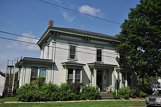
The George–Pine–Henry Historic District encompasses a residential area of the village of Bellows Falls, Vermont. Located west of downtown Bellows Falls, the area has a significant concentration of well-preserved late 19th and early 20th-century residences. It was listed on the National Register of Historic Places in 2010.
The Rockingham Village Historic District encompasses the traditional village center of the town of Rockingham, Vermont. Settled in the 18th century, the district, located mainly on Meeting House Road off Vermont Route 103, includes a variety of 18th and 19th-century houses, and has been little altered since a fire in 1908. It notably includes the 18th-century National Historic Landmark Rockingham Meeting House. The district was listed on the National Register of Historic Places in 2008.
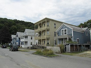
The Williams Street Extension Historic District encompasses a locally architecturally distinctive residential area on Williams Street in Bellows Falls, a village of Rockingham, Vermont. Developed between about 1880 and 1930, the neighborhood has a collection of 15 historically significant well-preserved worker housing units. It was listed on the National Register of Historic Places in 2010.
The Vergennes Residential Historic District encompasses a neighborhood south of downtown Vergennes, Vermont that encapsulates an architectural cross-section of the city's 19th and early 20th-century residential history. Set on Water, Maple, and Green Streets, it includes houses built and occupied by a diversity of the city's economic classes, from mill owners to laborers. The district was listed on the National Register of Historic Places in 2003.

The Terraces Historic District encompasses a historic late 19th and early 20th-century residential area of White River Junction, Vermont. The district, developed as an upper middle-class residential area beginning in 1880, features a variety of architectural styles encapsulating the community's growth through about 1930. It was listed on the National Register of Historic Places in 2012.

The Main Street–College Street Historic District encompasses a historically fashionable residential area of Burlington, Vermont. Principally located along Main and College Streets between South Winooski and South Williams Streets, the area was one of the city's most exclusive residential areas from the early 19th century to the early 20th century, and includes a diversity of high quality architecture from that period. It was listed on the National Register of Historic Places in 1988.

The Pearl Street Historic District of Burlington, Vermont encompasses part of the city's first major east-west transportation arteries, which developed from a fashionable residential area in the early 19th century to its present mixed use. It contains one of the city's highest concentrations of early Federal period architecture, as well as a number of fine Queen Anne and Colonial Revival houses. It was listed on the National Register of Historic Places in 1984.

The Maple Street–Clarks Avenue Historic District encompasses a historic 19th-century immigrant neighborhood of St. Johnsbury, Vermont. Located northwest of the downtown area on a sloping hillside, it consists of tenements and single-family houses built for Irish and French Canadian immigrants, sometimes grouped in ways that facilitated the support of large extended families. The district was listed on the National Register of Historic Places in 1994.

The West End North Historic District encompasses a neighborhood of late 19th and early 20th century residential architecture in western Hartford, Connecticut and eastern West Hartford, Connecticut. Roughly bounded by Prospect, Elizabeth, and Lorraine Streets and Farmington Avenue, the area includes a large number of Colonial Revival and Queen Anne houses, as well as numerous buildings in other period styles, with only a small number of losses. It was listed on the National Register of Historic Places in 1985.


