
The Burt Henry Covered Bridge, also known as the Henry Covered Bridge or just the Henry Bridge, is a covered bridge that spans the Walloomsac River near Bennington, Vermont. A Town lattice truss bridge, it carries River Road, just south of the village of North Bennington. Originally built about 1840, it was listed on the National Register of Historic Places in 1973 as Bennington County's oldest covered bridge. It was rebuilt in 1989 by the Vermont Agency of Transportation.

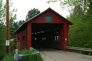
The Brown Covered Bridge is a wooden covered bridge in Shrewsbury, Vermont. Located in the northwestern part of the town, it carries Upper Cold River Road over the Cold River. It was closed to vehicular traffic in 2011 due to damage from Hurricane Irene and reopened as a National Historic Site on July 5, 2016. Built in 1880 by noted Vermont bridgewright Nichols M. Powers, it was designated a National Historic Landmark in 2014, cited as one of the finest and least-altered examples of a Town lattice truss covered bridge in the United States.

The Worrall Covered Bridge, also known as the Woralls Bridge is a wooden covered bridge carrying Williams Road across the Williams River in Rockingham, Vermont, United States. Built about 1870, it is the only surviving 19th-century covered bridge in the town, after the Hall Covered Bridge collapsed in 1980 and was replaced in 1982, and the Bartonsville Covered Bridge was washed away by Hurricane Irene in 2011 and replaced in 2012-2013. The bridge was listed on the National Register of Historic Places in 1973.

The Kingsley Covered Bridge is a wooden covered bridge carrying East Street across the Mill River in Clarendon, Vermont. Built about 1870, it is the town's only surviving 19th-century covered bridge. The bridge was listed on the National Register of Historic Places in 1974.

The Silk Covered Bridge is a covered bridge, carrying Silk Road across the Walloomsac River between downtown Bennington, Vermont and the village of North Bennington, United States. A Town lattice truss bridge, it was built in 1840, and is one of three covered bridges across the river in fairly close proximity. It was added to the National Register of Historic Places in 1973.

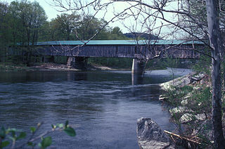
The West Dummerston Covered Bridge is a historic covered bridge spanning the West River in Dummerston, Vermont, between Vermont Route 30 and Camp Arden Road. Built in 1872, it is at 280 feet (85 m) the longest covered bridge entirely within the state of Vermont. It was listed on the National Register of Historic Places in 1973.
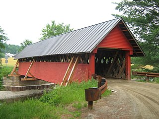
The Northfield Falls Covered Bridge, also called the Station Covered Bridge, is a wooden covered bridge that carries Cox Brook Road across the Dog River in Northfield, Vermont. Built in 1872, this Town lattice truss bridge is one of five surviving covered bridges in the town, and one of two that are visible from each other. It was listed on the National Register of Historic Places in 1974.

The Brookline-Newfane Bridge is a historic bridge spanning the West River between Brookline and Newfane, Vermont on Grassy Brook Road. It is a camelback through truss bridge, built in 1928 by the Berlin Construction Company in the wake of Vermont's devastating 1927 floods. The bridge was listed on the National Register of Historic Places in 2007 as Bridge 19, at which time it was one of seven surviving camelback bridges in the state. It last underwent a major rehabilitation in 2003-4.

The Creamery Covered Bridge is a historic covered bridge in West Brattleboro, Vermont. Now closed to traffic, the Town lattice truss bridge formerly carried Guilford Road across Whetstone Brook, just south of Vermont Route 9. Built in 1879, it is Brattleboro's last surviving 19th-century covered bridge.

The Green River Covered Bridge is a covered bridge in western Guilford, Vermont. Built in the 1870s by Marcus Worden, it is a Town lattice truss bridge, carrying Green River Road over the eponymous river in a small rural village of the same name. It was listed on the National Register of Historic Places in 1973.

The Hall Covered Bridge, located in southern Rockingham, Vermont, carries Hall Bridge Road across the Saxtons River, just north of its junction with Vermont Route 121. It is a Town lattice truss bridge, built in 1982 as a replica of a circa-1867 bridge that was destroyed by an overweight truck in 1980. The bridge was listed on the National Register of Historic Places in 1973.

The Kidder Covered Bridge carries Kidder Hill Road across the South Branch Saxtons River, just south of the village center of Grafton, Vermont. The bridge was built about 1870, and is Grafton's last surviving 19th-century covered bridge. It is the shortest historic covered bridge in Windham County, and was listed on the National Register of Historic Places in 1973.
Scott Covered Bridge is a covered bridge spanning the West River in Townshend, Vermont. Built in 1870, it is at 277 feet (84 m) one of the longest covered bridges in the state, exhibiting three different forms of support: a Town lattice truss, kingpost trusses, and laminated arches. The bridge was listed on the National Register of Historic Places in 1973. It is closed to all traffic.

The South Newfane Bridge is a historic bridge, carrying Parish Hill Road across the Rock River in the village of South Newfane, Vermont. It is a Pratt through truss span, manufactured from rolled I-beams in 1939 to replace a bridge washed away in flooding. It was listed on the National Register of Historic Places in 1992.

The Dean Covered Bridge was a Town lattice truss covered bridge, carrying Union Street across Otter Creek in Brandon, Vermont. Built in 1840, it was one of Vermont's oldest covered bridges at the time of its destruction in 1986 by an arsonist. It was listed on the National Register of Historic Places, and was replaced by a modern steel and concrete bridge.

The Gorham Covered Bridge carries Gorham Bridge Road across Otter Creek in a rural area of Pittsford and Proctor, Vermont. It is a Town lattice truss bridge, built in 1841 by Abraham Owen and Nicholas M. Powers, the latter in the early stages of his career as a well-known bridgewright. The bridge was listed on the National Register of Historic Places in 1974.

The Upper Falls Covered Bridge, also known as the Downers Covered Bridge, spans the Black River, carrying Upper Falls Road just south of Vermont Route 131 in western Weathersfield, Vermont. The Town lattice truss bridge was built in 1840 and rebuilt in 2008. Its gable ends are distinctive for their Greek Revival styling. The bridge was listed on the National Register of Historic Places in 1973.

The Willard Covered Bridge is a historic covered bridge carrying Mill Street across the Ottauquechee River in Hartland, Vermont. It is the eastern of two covered bridges on the road, which are connected via a small island in the river; the western bridge was built in 2001. This bridge, built about 1870, was listed on the National Register of Historic Places in 1973.

Bridge 12 is a historic Parker through truss bridge, carrying Boston Post Road across the Missisquoi River in Enosburg, Vermont. Built in 1929 in the wake of Vermont's devastating 1927 floods, it is one a shrinking number of surviving truss bridges on the river. It was listed on the National Register of Historic Places in 2007.
The River Road Covered Bridge was a historic covered bridge, carrying Veilleux Road across the Missisquoi River in Troy, Vermont. Built in 1910, the Town lattice truss was the only surviving covered bridge in Troy from the historic period of covered bridge construction when it burned on February 6, 2021. It also exhibited some distinctive variations in construction from more typical Town lattices. It was listed on the National Register of Historic Places in 1974.


