
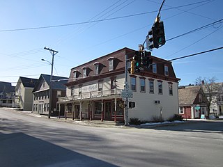
Rockingham is a Town in Windham County, on the southeastern Vermont border in the United States, along the Connecticut River. As of the 2020 census, the population was 4,832. Rockingham includes the incorporated villages of Bellows Falls and Saxtons River, as well as a large rural area west of Interstate 91.

West Hartford is an unincorporated community village in the town of Hartford, Windsor County, Vermont. It is the most rural of Hartford's five villages, situated on the White River and crossed by the Appalachian Trail. Almost half of the village was wiped out by a flood in 1927. Some areas have been developed for residential use but significant forest, farming and open lands remain. West Hartford features a country store, a post office, many shops, a small library and a town park along the White River, which is also a popular fishing site. The village center is listed on the National Register of Historic Places as the West Hartford Village Historic District.

Vermont Route 103 is a 42.036-mile-long (67.650 km) north–south state highway in southern Vermont, United States. It runs from U.S. Route 5 in Rockingham in the east to US 7 in Clarendon near Rutland in the west. The Vermont Country Store's second branch is one attraction along the route, as well as the Okemo Ski Resort in Ludlow.

Vermont Route 110 (VT 110) is a state highway in the U.S. state of Vermont. The highway runs 27.136 miles (43.671 km) from VT 14 in Royalton in northern Windsor County north to U.S. Route 302 in the town of Barre in central Washington County. VT 110 follows the valley of the First Branch White River through the Orange County towns of Tunbridge and Chelsea, which contain multiple historic buildings and covered bridges. The highway also follows the Jail Branch River, a tributary of the Winooski River, through Washington and Orange.
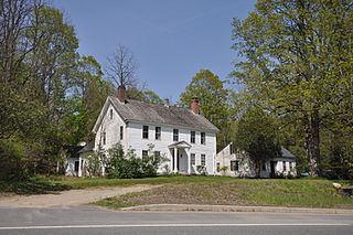
The Rockingham Village Historic District encompasses the traditional village center of the town of Rockingham, Vermont. Settled in the 18th century, the district, located mainly on Meeting House Road off Vermont Route 103, includes a variety of 18th and 19th-century houses, and has been little altered since a fire in 1908. It notably includes the 18th-century National Historic Landmark Rockingham Meeting House. The district was listed on the National Register of Historic Places in 2008.
West Townshend is an unincorporated village in Townshend, Vermont, United States. It is on the north side of a bend in the West River, upriver of the Townshend Dam. The entire village is listed on the National Register of Historic Places as the West Townshend Village Historic District. Its ZIP codes are 05359 and 05353.
The Wilmington Village Historic District encompasses a significant portion of the village center of Wilmington, Vermont. The village grew as a crossroads industrial center through the mid-19th century, and experienced relatively little growth afterward. The district was listed on the National Register of Historic Places in 1980.
The Tinmouth Historic District encompasses a cluster of residential and civic buildings that form the center of the village Tinmouth Center in Tinmouth, Vermont. The district contains a collection of well-preserved buildings, that are reflective of life in a rural 19th-century village. The district was listed on the National Register of Historic Places in 1980.

The Bethel Village Historic District encompasses the historic core of the village of Bethel in the town of Bethel, Vermont, USA. The L-shaped district extends along Main and Church Streets, including many of the village's commercial and civic buildings, as well as a significant number of 19th and early 20th-century residences. The district was listed on the National Register of Historic Places in 1976, and was slightly enlarged in 1990.

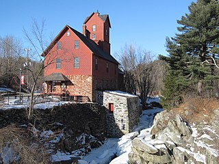
The Quechee Historic Mill District encompasses the historic heart of the village of Quechee, Vermont, a well-preserved 19th-century mill village. Extending along Quechee Main Street between the Old Quechee Road and the Quechee-West Hartford Road, the village was settled in the 1760s, and has an industrial history extending into the 20th century. It was listed on the National Register of Historic Places in 1997.

The Stockbridge Common Historic District encompasses the central portion of a rural 19th-century village center in Stockbridge, Vermont. Including the town common as well as a few buildings and an adjacent cemetery, it is a well-preserved example of a village bypassed by economic development during the 19th century industrial period. It was listed on the National Register of Historic Places in 1990.

The Weston Village Historic District encompasses the town center and principal village of Weston, Vermont. Centered on Farrar Park, which serves as the town green, it includes a diversity of architectural styles from the late 18th century to about 1935, and includes residential, civic, commercial, industrial and religious buildings. It was listed on the National Register of Historic Places in 1985.

The Thetford Center Historic District encompasses the village of Thetford Center in Thetford, Vermont. The village contains a well-preserved collection of early to mid-19th century architecture, a legacy of its period of greatest prosperity as an agricultural and industrial center. It was listed on the National Register of Historic Places in 1998.

The Tunbridge Village Historic District encompasses the early 19th-century village center of Tunbridge, Vermont. Stretched linearly along Vermont Route 110, the largely agricultural village reached its peak population around 1820, and was bypassed by the railroads, limiting later development. It was listed on the National Register of Historic Places in 1994.
The Jericho Village Historic District encompasses the historic industrial and commercial center of the village of Jericho, Vermont. Stretched along Vermont Route 15 south of Browns River, which powered the village's industries for many years, the village center includes a well-preserved array of 19th and early 20th-century buildings. The district was listed on the National Register of Historic Places in 1992.

The Plainfield Village Historic District encompasses a significant portion of the village of Plainfield, Vermont. Located in northernmost Plainfield on United States Route 2, the village grew in the 19th century as a mill town and service community for the surround agricultural areas, and has a well-preserved collection of Greek Revival and Italianate architecture. It was listed on the National Register of Historic Places in 1983.

The Waitsfield Village Historic District encompasses much of the main village center of Waitsfield, Vermont. Extending along Vermont Route 100 on either side of Bridge Street, it is a well-preserved example of a 19th-century village, with only a few sympathetic 20th-century additions. It was listed on the National Register of Historic Places in 1983.

The Warren Village Historic District encompasses the village center of Warren, Vermont, United States. Stretched mainly along Main Street east of the Mad River, it is a well-preserved 19th-century mill village, although most of its period mill infrastructure has been lost. The district has good examples of Greek Revival, Italianate, and Second Empire architecture. It was listed on the National Register of Historic Places in 1992.
East Calais is an unincorporated village in the town of Calais, Washington County, Vermont, United States. The community is located along Vermont Route 14, 10.3 miles (16.6 km) northeast of Montpelier. East Calais has a post office with ZIP code 05650, which opened on April 12, 1830. The heart of the village forms the East Calais Historic District, listed on the National Register of Historic Places in 2020.
East Hardwick is an unincorporated village in the town of Hardwick, Caledonia County, Vermont, United States. It is part of what is known as the Northeast Kingdom (NEK) of Vermont. The community is located on the Lamoille River and along Vermont Route 16, 16 miles (26 km) west-northwest of St. Johnsbury. East Hardwick has a post office with ZIP code 05836, which opened on October 10, 1810. According to a 1937 WPA Federal Writers Project Guidebook, East Hardwick is a "side hill village spilling from the level of a plateau down a sharp incline in the valley of the Lamoille. It is surrounded by rich farm lands, Maple groves and forests."


