
Bellows Falls is an incorporated village located in the town of Rockingham in Windham County, Vermont, United States. The population was 2,747 at the 2020 census. Bellows Falls is home to the Green Mountain Railroad, a heritage railroad; the annual Roots on the River Festival; and the No Film Film Festival.

Rockingham is a Town in Windham County, on the southeastern Vermont border in the United States, along the Connecticut River. As of the 2020 census, the population was 4,832. Rockingham includes the incorporated villages of Bellows Falls and Saxtons River, as well as a large rural area west of Interstate 91.

Saxtons River is an incorporated village in the town of Rockingham in Windham County, Vermont, United States. The population was 479 at the 2020 census. For over a hundred years, Saxtons River has been the home of Vermont Academy, an independent secondary school. Most of the village is a historic district listed on the National Register of Historic Places in 1986 as Saxtons River Village Historic District.

The Saxtons River is a 22.9-mile-long (36.9 km) river in the U.S. state of Vermont, a tributary of the Connecticut River. Its watershed covers 78 square miles (200 km2) and a range in altitude of 1,800 feet (550 m); land use is about 80% forested and 3% agricultural, and the upper river supports wild brook trout and brown trout, while Atlantic salmon occur but are usually limited to the area below Twin Falls on the lower river.
Vermont Route 103 is a 42.036-mile-long (67.650 km) north–south state highway in southern Vermont, United States. It runs from U.S. Route 5 in Rockingham in the east to US 7 in Clarendon near Rutland in the west. The Vermont Country Store's second branch is one attraction along the route, as well as the Okemo Ski Resort in Ludlow.

The Bartonsville Covered Bridge is a wooden covered bridge in the village of Bartonsville, in Rockingham, Vermont, United States. The bridge is a lattice truss style with a 151-foot span, carrying Lower Bartonsville Road over the Williams River. It was built in 2012, replacing a similar bridge built in 1870 by Sanford Granger. The 1870 bridge, which was listed on the National Register of Historic Places, was destroyed in 2011 in flooding caused by Hurricane Irene.

Bellows Falls station is an Amtrak intercity rail station located in the Bellows Falls village of Rockingham, Vermont, United States. The station is served by the single daily round trip of the Washington, D.C.–St. Albans Vermonter. It has a single side platform adjacent to the single track of the New England Central Railroad mainline.

The Williams River is a 27.0-mile (43.5 km) river in the US state of Vermont. It is a tributary of the Connecticut River. Its watershed covers 117 square miles; land use is about 80% forested and 4% agricultural, and the upper river supports wild brook trout and brown trout.

The Rockingham Meeting House, also known as Old North Meeting House and First Church in Rockingham, is a historic civic and religious building on Meeting House Road in Rockingham, Vermont, United States. The Meeting House was built between 1787 and 1801 and was originally used for both Congregational church meetings as well as civic and governmental meetings. Church services ceased in 1839 but town meetings continued to be held in it until 1869. It was restored in 1906 and has been preserved.

The Oak Hill Cemetery Chapel is a historic chapel, located in the Oak Hill Cemetery off Pleasant Street in Bellows Falls, Vermont. Built about 1885, it is one of a small number of 19th-century cemetery chapels in the state, and is the most modestly decorated of those, with vernacular Gothic Revival elements. The building was listed on the National Register of Historic Places in 1991.
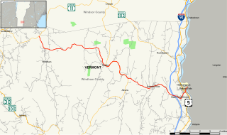
Vermont Route 121 (VT 121) is a state highway in the U.S. state of Vermont. The highway runs 21.439 miles (34.503 km) from VT 11 in Londonderry east to U.S. Route 5 in the incorporated village of Bellows Falls in the town of Rockingham. VT 121 follows the Saxtons River in northern Windham County. The highway has a pair of gravel sections in the towns of Windham and Grafton.

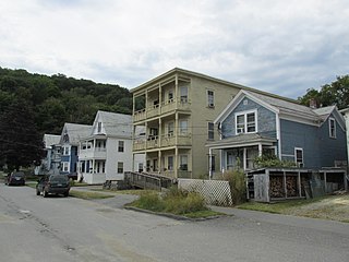
The Bellows Falls Neighborhood Historic District encompasses a residential area of the village of Bellows Falls, Vermont. Located south of downtown Bellows Falls, the area has one of the largest concentrations of well-preserved 19th century residences in southern Vermont. It was listed on the National Register of Historic Places in 2002, and enlarged in 2007.

The George–Pine–Henry Historic District encompasses a residential area of the village of Bellows Falls, Vermont. Located west of downtown Bellows Falls, the area has a significant concentration of well-preserved late 19th and early 20th-century residences. It was listed on the National Register of Historic Places in 2010.

The Hall Covered Bridge, located in southern Rockingham, Vermont, carries Hall Bridge Road across the Saxtons River, just north of its junction with Vermont Route 121. It is a Town lattice truss bridge, built in 1982 as a replica of a circa-1867 bridge that was destroyed by an overweight truck in 1980. The bridge was listed on the National Register of Historic Places in 1973.

The Houghtonville Historic District encompasses a cluster of residential properties that are all that remain of one of the early industrial areas of Grafton, Vermont. Located west of Grafton Village on Houghtonville Road, it includes ten well-preserved 19th-century houses, some located on properties where early mills once stood. The district was listed on the National Register of Historic Places in 2015.

The Westminster Terrace Historic District encompasses a locally architecturally distinctive residential area on Westminster Terrace in Bellows Falls and Westminster, Vermont. First developed between about 1880 and 1910, the neighborhood has high-quality late 19th-century homes, interspersed with later mid-20th century development. It was listed on the National Register of Historic Places in 2010.
The Williams Street Extension Historic District encompasses a locally architecturally distinctive residential area on Williams Street in Bellows Falls, a village of Rockingham, Vermont. Developed between about 1880 and 1930, the neighborhood has a collection of 15 historically significant well-preserved worker housing units. It was listed on the National Register of Historic Places in 2010.

Bellows Falls Canal is a canal constructed to allow boat traffic to bypass Great Falls on the Connecticut River in Bellows Falls, Vermont. It was constructed by the Bellows Falls Canal Company and was one of the first canals in the United States. It was used for transport, to power mills, and later for hydroelectric power. The Bellows Falls Downtown Historic District includes the canal.

Rockingham Free Public Library is one of four Carnegie Libraries in the state of Vermont. The building, in Bellows Falls, Vermont, a village of Rockingham, Vermont, was designed by Boston architects McLean & Wright in Classical Revival style. The Carnegie grant was offered in 1905. The town took a while to decide on allocating matching funds. The library officially opened on November 23, 1909. A children's annex was added to the building in 1929. In 2003 a new entryway and elevator were added for improved accessibility.

Great Falls is a waterfall along the Connecticut River between Walpole, New Hampshire, and Bellows Falls, Vermont. It has also been called Bellows Falls, and its Abenaki name is Kitchee Pontegu, which means "great falls". Great Falls became its official name, based on local usage, in 2016. It drops 52 feet (16 m), and the village of Bellows Falls was established next to it, to take advantage of its water power. Previously, the main settlement in town, Rockingham Village, was on a high point of land overlooking the Williams River, with no potential for water power.


