
Putney is a town in Windham County, Vermont, United States. The population was 2,617 at the 2020 census.

The Patterson Viaduct was built by the Baltimore and Ohio Railroad (B&O) as part of its Old Main Line during May to December 1829. The viaduct spanned the Patapsco River at Ilchester, Maryland. It was heavily damaged by a flood in 1868 and subsequently replaced with other structures. In 2006, it was restored to limited service when a footbridge was built atop the surviving arch and abutments.

The West Dummerston Covered Bridge is a historic covered bridge spanning the West River in Dummerston, Vermont, between Vermont Route 30 and Camp Arden Road. Built in 1872, it is at 280 feet (85 m) the longest covered bridge entirely within the state of Vermont. It was listed on the National Register of Historic Places in 1973.

The Lower Cox Brook Covered Bridge is a wooden covered bridge that crosses Cox Brook in Northfield, Vermont on Cox Brook Road. Built in 1872, it is one of five surviving 19th-century covered bridges in the town, in the only place in Vermont where two historic bridges are visible from each other. It was listed on the National Register of Historic Places in 1974.

James Otis Follett was a farmer, stonemason, and builder of bridges from Townshend, Vermont. He has been described as "an intuitive engineer, a farmer and mason."

The Stone Arch Bridge is a stone arch railroad bridge in Keene, New Hampshire, United States. Built in 1847 to carry the Cheshire Railroad, it is one of the best-preserved pre-1850 stone arch bridges in the nation. The bridge was listed on the National Register of Historic Places in 2012, and the New Hampshire State Register of Historic Places in 2006. It now carries a multi-purpose rail trail.

The Gilsum Stone Arch Bridge carries Surry Road over the Ashuelot River in Gilsum, New Hampshire. Built in 1862–63, it is one of the highest stone arch bridges in the state. It has a span of 47 feet 8 inches (14.53 m), and an average height over the river of 36 feet 6 inches (11.13 m). The roadway is 43 feet 6 inches (13.26 m) above the riverbed. It stands on the site of four previous bridges, where the river passes through a deep gorge. The previous bridge was also a stone arch bridge, which was built in 1860 and collapsed a few months later. It was designed by William Leonard Kingsbury, a local official; its builders are not known because the town's records were destroyed in a fire. The present bridge's vault is carefully constructed from dry-laid granite voussoirs that were shaped for a very precise fit, with larger stones at the lower ends of the arch, and a smaller ones at the crown. Some of the stones were left with rough surfaces, while others were hammered smooth.

The Stone Arch Underpass is a historic stone arch bridge spanning Glen Road in Lebanon, New Hampshire. Built about 1848, it carried the Boston and Maine Railroad's former Northern Line. It is one of a small number of 19th-century stone arch bridges in the state, and the only one known in central western New Hampshire. The bridge was listed on the National Register of Historic Places in 1985. The railroad right-of-way has been functionally abandoned, and the bridge may become part of a continuation of the Northern Rail Trail.

The Creamery Covered Bridge is a historic covered bridge in West Brattleboro, Vermont. Now closed to traffic, the Town lattice truss bridge formerly carried Guilford Road across Whetstone Brook, just south of Vermont Route 9. Built in 1879, it is Brattleboro's last surviving 19th-century covered bridge.
The Follett Stone Arch Bridge Historic District encompasses a group of four stone arch bridges in southwestern Townshend, Vermont. All four bridges were built by James Otis Follett, a local self-taught mason, between 1894 and 1910, and represent the single greatest concentration of surviving bridges he built. The district was listed on the National Register of Historic Places in 1976.

The Rice Farm Road Bridge is a historic bridge in Dummerston, Vermont. It is an iron Warren through truss, spanning the West River between Vermont Route 30 and Rice Farm Road. Built in 1892, it is one of the state's oldest surviving metal truss bridges. It was listed on the National Register of Historic Places in 1995.

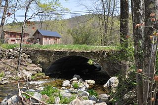
The Sacketts Brook Stone Arch Bridge, also known locally as the Hi-Lo Biddy Stone Arch Bridge, is a historic bridge just outside the village of Putney, Vermont. It is a stone arch bridge that formerly carried Mill Street across Sacketts Brook, about 0.25 miles (0.40 km) east of United States Route 5. It was built in 1906 by James Otis Follett, an area stonemason, and is one of a few surviving examples of his work. The bridge was listed on the National Register of Historic Places in 1976.
The Simpsonville Stone Arch Bridge is a historic stone arch bridge, carrying Vermont Route 35 across Simpson Brook, north of the village of Townshend, Vermont. Built about 1909, it is one of a few surviving bridges in the region built by local mason James Otis Follett. It was listed on the National Register of Historic Places in 1977.

The West Townshend Stone Arch Bridge carries Round Hill Road across Tannery Brook in the village of West Townshend, Vermont. Built about 1910, it is one of the few surviving bridges of a group built by local mason James Otis Follett in the early 20th century. It was listed on the National Register of Historic Places in 1977.
West Townshend is an unincorporated village in Townshend, Vermont, United States. It is on the north side of a bend in the West River, upriver of the Townshend Dam. The entire village is listed on the National Register of Historic Places as the West Townshend Village Historic District. Its ZIP codes are 05359 and 05353.

The Arch Bridge is a historic stone arch bridge, carrying Benner Road over the Pemaquid River near the village of Bristol Mills in Bristol, Maine. Probably built before 1800, it is one of the state's oldest stone bridges, and is remarkably well-preserved for its age. It was listed on the National Register of Historic Places in 2003.

Best's Covered Bridge(akaSwallow's Bridge) is a historic covered bridge in West Windsor, Vermont, that carries Churchill Road over Mill Brook, just south of Vermont Route 44. Built in 1889, it is an architecturally distinctive laminated arch structure with a post-and-beam superstructure. It was listed on the National Register of Historic Places in 1973.

The Kedron Brook Bridge is a historic stone arch bridge, carrying Densmore Hill Road across Kedron Brook in southern Woodstock, Vermont. Built about 1810, it is one of the state's older stone bridges, built from locally gathered stone. It was listed on the National Register of Historic Places in 1992.

The Lincoln Covered Bridge is a historic covered bridge, just south of U.S. Route 4 in West Woodstock, Vermont. Built in 1877, it is one of the only known examples of a wooden Pratt truss bridge in the United States. It was listed on the National Register of Historic Places in 1973.

The Center Road Culvert is a historic stone culvert on Center Road at Mallory Brook in East Montpelier, Vermont. It was built in 1899 as an early project after the establishment of the Vermont Highway Commission in 1898, and is a well-preserved example of dry-laid stone box culvert. The last major work on the culvert was performed in 1930, after it suffered damage in Vermont's devastating 1927 floods. VTrans recommended the culvert undergo preservation rather than replacement following damage from Hurricane Irene, and Mallory Brook is to be rerouted through a larger modern structure. It was listed on the National Register of Historic Places in 2020.


