
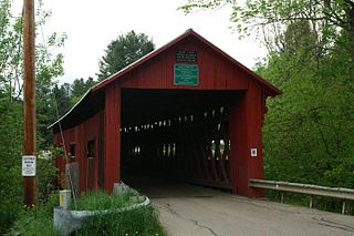
The Burt Henry Covered Bridge, also known as the Henry Covered Bridge or just the Henry Bridge, is a covered bridge that spans the Walloomsac River near Bennington, Vermont. A Town lattice truss bridge, it carries River Road, just south of the village of North Bennington. Originally built about 1840, it was listed on the National Register of Historic Places in 1973 as Bennington County's oldest covered bridge. It was rebuilt in 1989 by the Vermont Agency of Transportation.

The Kingsley Covered Bridge is a wooden covered bridge carrying East Street across the Mill River in Clarendon, Vermont. Built about 1870, it is the town's only surviving 19th-century covered bridge. The bridge was listed on the National Register of Historic Places in 1974.

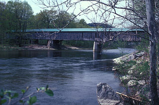
The Mount Orne Bridge is a covered bridge over the Connecticut River between Lancaster, New Hampshire, and Lunenburg, Vermont. It joins Elm Street in South Lancaster with River Road in Lunenburg. Built in 1911, it is one of two Howe truss bridges across the Connecticut River. It was listed on the National Register of Historic Places in 1976.

The East Fairfield Covered Bridge is a covered bridge that carries Bridge Street across Black Creek in the East Fairfield village of Fairfield, Vermont. Built about 1865, it is the town's only surviving 19th century covered bridge. It was listed on the National Register of Historic Places in 1974.

The Arlington Green Covered Bridge is a covered bridge located off Vermont Route 313 in Arlington, Vermont. The Town lattice truss bridge carries Covered Bridge Road across Batten Kill. It was built in 1852 and was listed on the National Register of Historic Places in 1973. It is one of Vermont's oldest surviving bridges.
The Northfield Falls Covered Bridge, also called the Station Covered Bridge, is a wooden covered bridge that carries Cox Brook Road across the Dog River in Northfield, Vermont. Built in 1872, this Town lattice truss bridge is one of five surviving covered bridges in the town, and one of two that are visible from each other. It was listed on the National Register of Historic Places in 1974.

The Slaughter HouseCovered Bridge is a wooden covered bridge that carries Slaughterhouse Road across the Dog River in Northfield, Vermont. The Queen post truss bridge is one of five surviving 19th-century bridges in the town. It was listed on the National Register of Historic Places in 1974.

The Longley Covered Bridge, also known as the Harnois Covered Bridge, is a wooden covered bridge that crosses the Trout River in Montgomery, Vermont on Longley Bridge Road. Built in 1863, this Town lattice truss bridge is the oldest of a group of area bridges built by brothers Sheldon & Savannah Jewett. It was listed on the National Register of Historic Places in 1974. The bridge is closed to traffic, and has been bypassed by an adjacent temporary bridge.

The Montgomery Covered Bridge, also known as the Lower Covered Bridge is a wooden covered bridge that carries Montgomery Road across the North Branch of the Lamoille River in Waterville, Vermont. Built in 1887, it is one of three covered bridges in the town, and one of five on the river in a five-mile span. It was listed on the National Register of Historic Places in 1974.

The Kidder Covered Bridge carries Kidder Hill Road across the South Branch Saxtons River, just south of the village center of Grafton, Vermont. The bridge was built about 1870, and is Grafton's last surviving 19th-century covered bridge. It is the shortest historic covered bridge in Windham County, and was listed on the National Register of Historic Places in 1973.
Scott Covered Bridge is a covered bridge spanning the West River in Townshend, Vermont. Built in 1870, it is at 277 feet (84 m) one of the longest covered bridges in the state, exhibiting three different forms of support: a Town lattice truss, kingpost trusses, and laminated arches. The bridge was listed on the National Register of Historic Places in 1973. It is closed to all traffic.
The Williamsville Covered Bridge is a historic covered bridge, carrying Dover Road over the Rock River in Newfane, Vermont. Probably built in the 1870s, this Town lattice truss bridge is probably the oldest covered bridge in Windham County, and is the only one surviving in the town of Newfane. It was listed on the National Register of Historic Places in 1973.

The Depot Covered Bridge is a historic Town lattice truss bridge, carrying Depot Hill Road over Otter Creek in Pittsford, Vermont. The bridge was built about 1840, and is one of Vermont's older covered bridges. It underwent restoration in the 1980s, and was subsequently reinforced with steel stringers. It was listed on the National Register of Historic Places in 1974.
The Sanderson Covered Bridge is a historic covered bridge, which carries Pearl Street over Otter Creek in Brandon, Vermont. Built about 1840, it is one of Vermont's oldest covered bridges, and is the only remaining 19th century bridge in Brandon. It was listed on the National Register of Historic Places in 1974.
The Moxley Covered Bridge is a historic covered bridge carrying Moxley Road across the First Branch White River in southern Chelsea, Vermont. Built in 1886-87, it is the town's only surviving 19th-century covered bridge. It was listed on the National Register of Historic Places in 1974.

The Upper Falls Covered Bridge, also known as the Downers Covered Bridge, spans the Black River, carrying Upper Falls Road just south of Vermont Route 131 in western Weathersfield, Vermont. The Town lattice truss bridge was built in 1840 and rebuilt in 2008. Its gable ends are distinctive for their Greek Revival styling. The bridge was listed on the National Register of Historic Places in 1973.
The Willard Covered Bridge is a historic covered bridge carrying Mill Street across the Ottauquechee River in Hartland, Vermont. It is the eastern of two covered bridges on the road, which are connected via a small island in the river; the western bridge was built in 2001. This bridge, built about 1870, was listed on the National Register of Historic Places in 1973.

The Woodstock Warren Through Truss Bridge was a historic iron bridge that carried Bridges Road across the Ottauquechee River in western Woodstock, Vermont. The bridge was built in 1925, and was a rare example of the state of a double-intersection Warren through truss. The bridge was swept away by flooding caused by Hurricane Irene in 2011; it was listed on the National Register of Historic Places in 1992.

Bridge 12 is a historic Parker through truss bridge, carrying Boston Post Road across the Missisquoi River in Enosburg, Vermont. Built in 1929 in the wake of Vermont's devastating 1927 floods, it is one a shrinking number of surviving truss bridges on the river. It was listed on the National Register of Historic Places in 2007.

The Jaynes Covered Bridge is a historic covered bridge, carrying Codding Hollow Road across the North Branch Lamoille River in Waterville, Vermont. Built in 1877, it is one of three 19th-century covered bridges in the town, and one of five to span the North Branch Lamoille in a five-mile span. It was listed on the National Register of Historic Places in 1974.


