
The West River is a tributary of the Connecticut River, about 53.8 miles (86.6 km) long, in southern Vermont in the United States. According to the Geographic Names Information System, it has also been known historically as "Wantastiquet" and as "Waters of the Lonely Way". Its watershed covers 423 square miles (1,100 km2); land use is about 90% forested and 3% agricultural, and the upper river supports wild native brook and wild brown trout, while Atlantic salmon occur in most of the river.

The Taftsville Historic District encompasses a historic 19th-century industrial village that is mostly in Woodstock, Vermont. Flanking the Ottauquechee River and extending up Happy Valley Road, the area developed around a metal tool factory established by members of the Taft family in 1793. Important elements from its early history include the Taftsville Store, built by the Taft family in 1840, and the Taftsville Covered Bridge, built in 1836. The district was listed on the National Register of Historic Places in 2001.

The Crown Point Road, or the Crown Point Military Road, is a historic road built in 1759-60, mostly in what is now the United States state of Vermont. It was built by British Army and colonial militia forces to connect Fort Crown Point near the southern end of Lake Champlain to the Fort at Number 4 in what is now Charlestown, New Hampshire. It was the first major road in Vermont, spurring development along its route after the French and Indian War. Fragments of the road are still visible in largely period condition, or have been paved over, while others have disappeared into the forest. Sections of the road located in Weathersfield have been listed on the National Register of Historic Places.

James Otis Follett was a farmer, stonemason, and builder of bridges from Townshend, Vermont. He has been described as "an intuitive engineer, a farmer and mason."

The East Putney Brook Stone Arch Bridge is a historic stone arch bridge in eastern Putney, Vermont. Built in 1902, it is a rare statewide example of a 20th-century stone bridge, and one of a number of such area bridges built by Townshend farmer and mason James Otis Follett. It was listed on the U.S. National Register of Historic Places in 1976. The bridge is located just west (upstream) of the present alignment of River Road, which it formerly carried.

West Dover is a village in the central part of Dover, Vermont. The village center, located on Vermont Route 100 at Cross Town and Valley View Roads, was listed on the National Register of Historic Places in 1985 as the West Dover Historic District. The village is a major service point for the nearby Mount Snow ski area. The ZIP Code for West Dover is 05356
The Follett Stone Arch Bridge Historic District encompasses a group of four stone arch bridges in southwestern Townshend, Vermont. All four bridges were built by James Otis Follett, a local self-taught mason, between 1894 and 1910, and represent the single greatest concentration of surviving bridges he built. The district was listed on the National Register of Historic Places in 1976.

The Grafton Village Historic District encompasses the historic village center of the town of Grafton, Vermont. The village was developed in the early-to-mid 19th century, and has retained the character of that period better than many small communities in the state. The district was listed on the National Register of Historic Places in 2010.
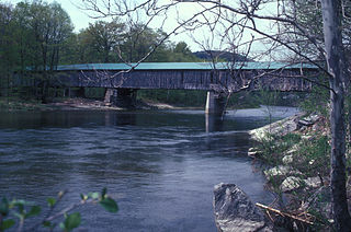
Scott Covered Bridge is a covered bridge spanning the West River in Townshend, Vermont. Built in 1870, it is at 277 feet (84 m) one of the longest covered bridges in the state, exhibiting three different forms of support: a Town lattice truss, kingpost trusses, and laminated arches. The bridge was listed on the National Register of Historic Places in 1973. It is closed to all traffic.

The Rockingham Village Historic District encompasses the traditional village center of the town of Rockingham, Vermont. Settled in the 18th century, the district, located mainly on Meeting House Road off Vermont Route 103, includes a variety of 18th and 19th-century houses, and has been little altered since a fire in 1908. It notably includes the 18th-century National Historic Landmark Rockingham Meeting House. The district was listed on the National Register of Historic Places in 2008.

The Sacketts Brook Stone Arch Bridge, also known locally as the Hi-Lo Biddy Stone Arch Bridge, is a historic bridge just outside the village of Putney, Vermont. It is a stone arch bridge that formerly carried Mill Street across Sacketts Brook, about 0.25 miles (0.40 km) east of United States Route 5. It was built in 1906 by James Otis Follett, an area stonemason, and is one of a few surviving examples of his work. The bridge was listed on the National Register of Historic Places in 1976.
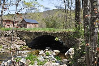
The Simpsonville Stone Arch Bridge is a historic stone arch bridge, carrying Vermont Route 35 across Simpson Brook, north of the village of Townshend, Vermont. Built about 1909, it is one of a few surviving bridges in the region built by local mason James Otis Follett. It was listed on the National Register of Historic Places in 1977.

The West Townshend Stone Arch Bridge carries Round Hill Road across Tannery Brook in the village of West Townshend, Vermont. Built about 1910, it is one of the few surviving bridges of a group built by local mason James Otis Follett in the early 20th century. It was listed on the National Register of Historic Places in 1977.
The Tinmouth Historic District encompasses a cluster of residential and civic buildings that form the center of the village Tinmouth Center in Tinmouth, Vermont. The district contains a collection of well-preserved buildings, that are reflective of life in a rural 19th-century village. The district was listed on the National Register of Historic Places in 1980.

The Bethel Village Historic District encompasses the historic core of the village of Bethel in the town of Bethel, Vermont, USA. The L-shaped district extends along Main and Church Streets, including many of the village's commercial and civic buildings, as well as a significant number of 19th and early 20th-century residences. The district was listed on the National Register of Historic Places in 1976, and was slightly enlarged in 1990.

The Thetford Center Historic District encompasses the village of Thetford Center in Thetford, Vermont. The village contains a well-preserved collection of early to mid-19th century architecture, a legacy of its period of greatest prosperity as an agricultural and industrial center. It was listed on the National Register of Historic Places in 1998.

The Waitsfield Village Historic District encompasses much of the main village center of Waitsfield, Vermont. Extending along Vermont Route 100 on either side of Bridge Street, it is a well-preserved example of a 19th-century village, with only a few sympathetic 20th-century additions. It was listed on the National Register of Historic Places in 1983.

The Warren Village Historic District encompasses the village center of Warren, Vermont, United States. Stretched mainly along Main Street east of the Mad River, it is a well-preserved 19th-century mill village, although most of its period mill infrastructure has been lost. The district has good examples of Greek Revival, Italianate, and Second Empire architecture. It was listed on the National Register of Historic Places in 1992.

The Guildhall Village Historic District encompasses the central common and surrounding buildings in the village center of Guildhall, Vermont. The town, the first to be settled in Vermont's Northeast Kingdom, has a history from the late 18th century as a commercial, civic, and industrial center, and is the shire town of Essex County. The district was listed on the National Register of Historic Places in 1980.

The Thresher Mill is a historic industrial facility on West Barnet Road in Barnet, Vermont. First developed in 1836, it was the last water-powered mill to operate on the Stevens River, lasting into the late 20th century. The property, which includes an original mill dam and a surviving 1872 mill building, as well as archaeological sites of other industrial buildings, was listed on the National Register of Historic Places in 1996. It is now styled Ben's Mill, and is a local museum.


