
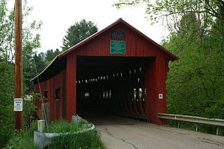
The West Dummerston Covered Bridge is a historic covered bridge spanning the West River in Dummerston, Vermont, between Vermont Route 30 and Camp Arden Road. Built in 1872, it is at 280 feet (85 m) the longest covered bridge entirely within the state of Vermont. It was listed on the National Register of Historic Places in 1973.

The Stony Brook Covered Bridge, also called the Moseley Covered Bridge, is a wooden covered bridge that crosses Stony Brook in Northfield, Vermont on Stony Brook Road. Built in 1899, it is one of two surviving 19th-century King post truss bridges in the state. It was listed on the National Register of Historic Places in 1974.
The Northfield Falls Covered Bridge, also called the Station Covered Bridge, is a wooden covered bridge that carries Cox Brook Road across the Dog River in Northfield, Vermont. Built in 1872, this Town lattice truss bridge is one of five surviving covered bridges in the town, and one of two that are visible from each other. It was listed on the National Register of Historic Places in 1974.

The Lower Cox Brook Covered Bridge is a wooden covered bridge that crosses Cox Brook in Northfield, Vermont on Cox Brook Road. Built in 1872, it is one of five surviving 19th-century covered bridges in the town, in the only place in Vermont where two historic bridges are visible from each other. It was listed on the National Register of Historic Places in 1974.

The Pine Brook Covered Bridge, also called the Wilder Covered Bridge, is a wooden covered bridge that crosses Pine Brook in Waitsfield, Vermont on North Road. Built in 1872, it is one two surviving 19th-century covered bridges in the town. It was listed on the National Register of Historic Places in 1974.

James Otis Follett was a farmer, stonemason, and builder of bridges from Townshend, Vermont. He has been described as "an intuitive engineer, a farmer and mason."

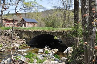
The East Putney Brook Stone Arch Bridge is a historic stone arch bridge in eastern Putney, Vermont. Built in 1902, it is a rare statewide example of a 20th-century stone bridge, and one of a number of such area bridges built by Townshend farmer and mason James Otis Follett. It was listed on the U.S. National Register of Historic Places in 1976. The bridge is located just west (upstream) of the present alignment of River Road, which it formerly carried.

The Samuel Morey Memorial Bridge is a historic bridge carrying New Hampshire Route 25A across the Connecticut River between Orford, New Hampshire and Fairlee, Vermont. The steel through-arch bridge was built in 1937–38 to replace an older wooden bridge which had been damaged by flooding in 1936. It spans 432 feet (132 m), stands about 35 feet (11 m) above the river, and its arches rise 85 feet (26 m) above the roadway. It rests on poured concrete abutments that have a light Art Deco or Moderne styling. Wing walls recede from the abutments into the banks in three stepped sections. Below the bridge in the river is visible some riprap, stone remnants of the old bridge's abutments and central pier. The bridge is of a "tied arch" design, in which the two arches are joined together by ties to distribute the active load. This is in contrast to the Justice Harlan Fiske Stone Bridge joining Brattleboro, Vermont and Chesterfield, New Hampshire, which was built about the same time, and distributes the active load to its abutments. The bridge components were manufactured by the American Bridge Company; construction was by Hagen-Thibodeau Construction Company at a contracted cost of just over $209,000.

The Sacketts Brook Stone Arch Bridge, also known locally as the Hi-Lo Biddy Stone Arch Bridge, is a historic bridge just outside the village of Putney, Vermont. It is a stone arch bridge that formerly carried Mill Street across Sacketts Brook, about 0.25 miles (0.40 km) east of United States Route 5. It was built in 1906 by James Otis Follett, an area stonemason, and is one of a few surviving examples of his work. The bridge was listed on the National Register of Historic Places in 1976.
The Simpsonville Stone Arch Bridge is a historic stone arch bridge, carrying Vermont Route 35 across Simpson Brook, north of the village of Townshend, Vermont. Built about 1909, it is one of a few surviving bridges in the region built by local mason James Otis Follett. It was listed on the National Register of Historic Places in 1977.

The West Townshend Stone Arch Bridge carries Round Hill Road across Tannery Brook in the village of West Townshend, Vermont. Built about 1910, it is one of the few surviving bridges of a group built by local mason James Otis Follett in the early 20th century. It was listed on the National Register of Historic Places in 1977.
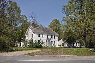
West Townshend is an unincorporated village in Townshend, Vermont, United States. It is on the north side of a bend in the West River, upriver of the Townshend Dam. The entire village is listed on the National Register of Historic Places as the West Townshend Village Historic District. Its ZIP codes are 05359 and 05353.

The Colburn Bridge is a historic bridge in Pittsford, Vermont. It is a masonry arch bridge, carrying U.S. Route 7 (US 7) across Sugar Hollow Brook a short way east of the town center. Built in 1899, it is one of a modest number of surviving masonry arch bridges in the state, and exhibits particularly high quality period workmanship. It was listed on the National Register of Historic Places in 1990.

Best's Covered Bridge(akaSwallow's Bridge) is a historic covered bridge in West Windsor, Vermont, that carries Churchill Road over Mill Creek, just south of Vermont Route 44. Built in 1889, it is an architecturally distinctive laminated arch structure with a post-and-beam superstructure. It was listed on the National Register of Historic Places in 1973.

The Bowers Covered Bridge(akaBrownsville Bridge) is a historic covered bridge, carrying Bible Hill Road across Mill Brook in the Brownsville section of West Windsor, Vermont. Built in 1919, it has a laminated-arch deck covered by a post-and-beam superstructure, similar to Best's Covered Bridge, Windsor's other historic covered bridge. It was listed on the National Register of Historic Places in 1973. It was rebuilt after being swept off its foundation in 2011 by Hurricane Irene, but has been damaged by vehicle strikes several times since then, and is being considered for closure.

The Kedron Brook Bridge is a historic stone arch bridge, carrying Densmore Hill Road across Kedron Brook in southern Woodstock, Vermont. Built about 1810, it is one of the state's older stone bridges, built from locally gathered stone. It was listed on the National Register of Historic Places in 1992.

The Lincoln Covered Bridge is a historic covered bridge, just south of U.S. Route 4 in West Woodstock, Vermont. Built in 1877, it is one of the only known examples of a wooden Pratt truss bridge in the United States. It was listed on the National Register of Historic Places in 1973.

The Quechee Gorge Bridge is a historic bridge, carrying U.S. Route 4 (US 4) across Quechee Gorge, near the Quechee village of Hartford, Vermont. Built in 1911, it is Vermont's oldest surviving steel arch bridge. It was listed on the National Register of Historic Places in 1990.
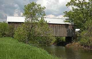
The Howe Covered Bridge is a historic covered bridge carrying Belknap Brook Road across the White River in Tunbridge, Vermont, just east of Vermont Route 110. Built in 1879, it is one of five surviving bridges in the town, one of the highest concentrations of covered bridges in the state. It was listed on the National Register of Historic Places in 1974.

The Greenbanks Hollow Covered Bridge is a historic covered bridge, carrying Greenbanks Hollow Road across Joes Brook in southern Danville, Vermont. It is the only surviving 19th-century covered bridge in the town. It was listed on the National Register of Historic Places in 1974.


