Bellows Falls is an incorporated village located in the town of Rockingham in Windham County, Vermont, United States. The population was 2,747 at the 2020 census. Bellows Falls is home to the Green Mountain Railroad, a heritage railroad; the annual Roots on the River Festival; and the No Film Film Festival.

Rockingham is a town along the Connecticut River in Windham County, Vermont, United States. As of the 2020 census, the population was 4,832. Rockingham includes the incorporated villages of Bellows Falls and Saxtons River, as well as a large rural area west of Interstate 91.

Saxtons River is an incorporated village in the town of Rockingham in Windham County, Vermont, United States. The population was 479 at the 2020 census. For over a hundred years, Saxtons River has been the home of Vermont Academy, an independent secondary school. Most of the village is a historic district listed on the National Register of Historic Places in 1986 as Saxtons River Village Historic District.

Bellows Falls station is an Amtrak intercity rail station located in the Bellows Falls village of Rockingham, Vermont, United States. The station is served by the single daily round trip of the Washington, D.C.–St. Albans Vermonter. It has a single side platform adjacent to the single track of the New England Central Railroad mainline.

The Homestead–Horton Neighborhood Historic District encompasses a small turn-of-the-20th century neighborhood area in Brattleboro, Vermont. Located on a portion of Canal Street and all of Horton and Homestead Places, the district includes a significant number of Queen Anne Victorians, as well as the Italianate home of Jacob Estey, proprietor of the Estey Organ Company, one of the city's larger employers. The district was listed on the National Register of Historic Places in 2009.

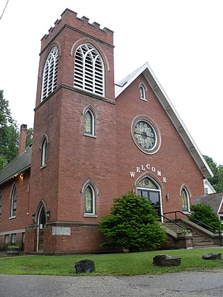
The Oak Hill Cemetery Chapel is a historic chapel, located in the Oak Hill Cemetery off Pleasant Street in Bellows Falls, Vermont. Built about 1885, it is one of a small number of 19th-century cemetery chapels in the state, and is the most modestly decorated of those, with vernacular Gothic Revival elements. The building was listed on the National Register of Historic Places in 1991.

The Exeter Waterfront Commercial Historic District encompasses the historic commercial and residential waterfront areas of Exeter, New Hampshire. The district extends along the north side of Water Street, roughly from Main Street to Front Street, and then along both sides of Water and High streets to the latter's junction with Portsmouth Street. It also includes properties on Chestnut Street on the north side of the Squamscott River. This area was where the early settlement of Exeter took place in 1638, and soon developed as a shipbuilding center. The district was listed on the National Register of Historic Places in 1980. It was enlarged in 1986 to include the mill complex of the Exeter Manufacturing Company on Chestnut Street.

Vermont Route 121 (VT 121) is a state highway in the U.S. state of Vermont. The highway runs 21.439 miles (34.503 km) from VT 11 in Londonderry east to U.S. Route 5 in the incorporated village of Bellows Falls in the town of Rockingham. VT 121 follows the Saxtons River in northern Windham County. The highway has a pair of gravel sections in the towns of Windham and Grafton.
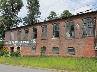
The Robertson Paper Company Complex was a historic industrial facility on Island Street in Bellows Falls, Vermont. It consisted of a collection of mostly-interconnected factory and related buildings, built between c. 1890 and c. 1960 by various paper-related companies. It was occupied and enlarged by the Robertson Paper Company between 1907 and its failure in 1987, at which time it was the longest-lived paper company in the state. The complex was listed on the National Register of Historic Places in 1990. It was demolished in 2018-19 as a Brownfields Economic Revitalization Alliance (BERA) project, with federal, state, and local funding.

The Canal Street–Clark Street Neighborhood Historic District encompasses a compact 19th-century working-class neighborhood of Brattleboro, Vermont. Most of its buildings are modest vernacular wood-frame buildings, erected between 1830 and 1935; there are a few apartment blocks, and one church. The district was listed on the National Register of Historic Places in 1993.

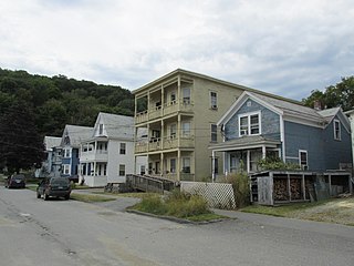
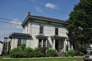
The George–Pine–Henry Historic District encompasses a residential area of the village of Bellows Falls, Vermont. Located west of downtown Bellows Falls, the area has a significant concentration of well-preserved late 19th and early 20th-century residences. It was listed on the National Register of Historic Places in 2010.
The Rockingham Village Historic District encompasses the traditional village center of the town of Rockingham, Vermont. Settled in the 18th century, the district, located mainly on Meeting House Road off Vermont Route 103, includes a variety of 18th and 19th-century houses, and has been little altered since a fire in 1908. It notably includes the 18th-century National Historic Landmark Rockingham Meeting House. The district was listed on the National Register of Historic Places in 2008.

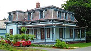
The Westminster Terrace Historic District encompasses a locally architecturally distinctive residential area on Westminster Terrace in Bellows Falls and Westminster, Vermont. First developed between about 1880 and 1910, the neighborhood has high-quality late 19th-century homes, interspersed with later mid-20th century development. It was listed on the National Register of Historic Places in 2010.
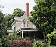
The Williams Street Extension Historic District encompasses a locally architecturally distinctive residential area on Williams Street in Bellows Falls, a village of Rockingham, Vermont. Developed between about 1880 and 1930, the neighborhood has a collection of 15 historically significant well-preserved worker housing units. It was listed on the National Register of Historic Places in 2010.

The Rutland Courthouse Historic District encompasses an architecturally cohesive area of civic and residential buildings in Rutland, Vermont. Roughly bounded by Court, Washington, South Main, and West Streets, the district was principally developed between 1850 and 1875, and includes a number of prominent municipal and county buildings, including the Rutland County courthouse, the Rutland Free Library, and the Grace Congregational United Church. The district was listed on the National Register of Historic Places in 1976.

The Bethel Village Historic District encompasses the historic core of the village of Bethel in the town of Bethel, Vermont, USA. The L-shaped district extends along Main and Church Streets, including many of the village's commercial and civic buildings, as well as a significant number of 19th and early 20th-century residences. The district was listed on the National Register of Historic Places in 1976, and was slightly enlarged in 1990.
The Vergennes Residential Historic District encompasses a neighborhood south of downtown Vergennes, Vermont that encapsulates an architectural cross-section of the city's 19th and early 20th-century residential history. Set on Water, Maple, and Green Streets, it includes houses built and occupied by a diversity of the city's economic classes, from mill owners to laborers. The district was listed on the National Register of Historic Places in 2003.
The Springfield Downtown Historic District encompasses the historic central business district of the town of Springfield, Vermont. Located in a narrow valley on the banks of the Black River, the town's architecture is primarily reflective of its importance as a manufacturing center in the late 19th and early-to-mid 20th centuries, with a cluster of commercial buildings surrounded by residential and industrial areas. It was listed on the National Register of Historic Places in 1983, and enlarged slightly in 1986.

The Morrisville Historic District encompasses most of the historic commercial downtown area of the village of Morrisville in Morristown, Vermont. Developed in the early 19th century as a service town for the surrounding agricultural areas, it was transformed into a major service regional commercial center by the arrive of the railroad in 1872. Its surviving architecture is largely reflective of these two time periods. It was listed on the National Register of Historic Places in 1983, and enlarged in 2007.

Bellows Falls Canal is a canal constructed to allow boat traffic to bypass Great Falls on the Connecticut River in Bellows Falls, Vermont. It was constructed by the Bellows Falls Canal Company and was one of the first canals in the United States. It was used for transport, to power mills, and later for hydroelectric power. The Bellows Falls Downtown Historic District includes the canal.